Wild, windy and harsh, yet stunningly beautiful. (A description of Lo Manthang, at Buddhisttravel.com)
It was a chance to see trans-Himalayan region of upper Mustang, the isolated Kingdom of Lo, and the ancient walled city of Manthang, before the region suffers irreversible change. Lo is home to the last vestiges of traditional Tibetan culture: old villages, medieval forts, monasteries, Buddhist art, relics, sacred caves, and more. But not for long.
 A half-century old goal
It’s been my goal since the 1960s to trek to Lo, upper Mustang. I’ve been to nearby Muktinath shrine many times, and I once peered into upper Mustang from the 13,000 foot ridge straight up west above Kagbeni. But no further.
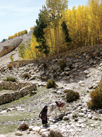
In 2010 I decided that since I wasn’t getting any younger, and was physically fit, it was time. So I recruited 12 trekkers to join me and early in October 2011 we flew to the Mustang District airport at Jomsom (8,900 ft.), ready to go to Lo. Our Nepali team was also ready: guide Santosh Sherchan, his assistant Pasang, two wranglers (for the three ponies we hired for the slowest of us to ride as needed), and a muleteer with seven mules (for our duffel).
After breakfast at Om’s Home Hotel, Jomsom, we set out. Day 1: up the Kali Gandaki river to Kagbeni where the upper Mustang trail officially begins. That three hour stroll is deceptively easy, but don’t be fooled—the trail to Lo is not for wimps. We did it up and back in 10 days, crossing 11 high passes (three over 13,000 feet), without incident or accident. At times, though, it did seem “harsh.”
Kagbeni, in wind and dust
Kagbeni (9,220 ft.) sits strategically at the sacred confluence (beni) of the Jhong and the Kali Gandaki rivers, and at the junction of four trade routes. Centuries ago, the king of Kag earned his keep by taxing the trade to/from Manthang and Tibet (north), and lower Mustang (south), Muktinath (east), and Dolpa (west). Clever fellow.
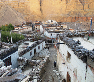
Because Kagbeni is located at a narrow point on the river, stiff winds and dust storms blow through like fury each afternoon, wildly twisting and snapping the prayer flags on every rooftop. Only the great red gompa (Buddhist monastery) on a bluff in the old part of town stands firm, impervious to the gales. In recent years, this windblown old traders’ town has become a popular destination for trekkers and a major stop on the east-west Great Himalaya Trail.
There are a dozen hotels to choose from (Niligiri, Annapurna, Everest, Dhaulagiri and others), an Oasis Restaurant and Bar, the cleverly named ‘Yac-Donald’s Cyber Café’, and an ‘Illy’ brand Italian gourmet coffee shop. My choice was the legendary old Red House Lodge. When I first stayed there in 1964 it was a private home and I remember a lot of well-armed Tibetan Khampa ‘Freedom Fighters’ hanging around. Now it’s a commercial lodge, but because it was too small for our group we had to settle for the Paradise-Trekker Home (neither heavenly nor homely, and no Khampas).
In trekking season Kagbeni is abuzz with foreigners. And during Hindu festivals it fills up with hundreds of pilgrims enroute to the shrine at Muktinath, over 3,000 feet higher, east, up the Jhong river. Before going up valley, however, they perform special rituals at Kagbeni in memory of deceased kinfolk, including a dip in the frigid waters at the beni. We didn’t.
Day 2: we got an early start to get as far as possible ahead of the wind. While walking through old Kagbeni we were confronted by the town’s two mute guardians—a crude, sexually explicit figure of a naked woman at the south entrance and a tall male image, prominently tumescent, at the north.
Upper Mustang is a restricted area for sensitive cultural and environmental reasons. It’s only been open to group treks since 1992. Permits (pre-paid in Kathmandu) cost $500 each for a 10-day trek. Santosh registered us at the Kagbeni checkpost as we passed out of town.
Chhusang and Chele
For awhile we followed the jeep track across a barren rocky landscape. On a high mesa before Tangbe we passed a Chinese-funded organic farm and a small tea shop, then continued on to Chhusang for lunch.
Out on the river flats between Jomsom and Kagbeni and north of Chhusang we looked for saligrams, the 165 million year old black ammonite fossils that are ardently sought by devout Hindus who worship them as representations of Lord Vishnu. Ammonites are fossilized cephalopods, a type of coiled mollusk that once lived in the warm shallow Tethys sea separating prehistoric Gondwanaland (India) from Laurasia (Tibet). Saligrams show up in the high mountains and along the river bed as a result of plate tectonics. As the two super continents slowly collided, the sea bed rose up to form the Himalayas. They are still rising, but at an imperceptible rate.
 Beyond Chhusang the Kali Gandaki disgorges dramatically out of a natural red rock tunnel. After crossing to the west bank on a metal footbridge we climbed directly uphill to Chele, our night stop.
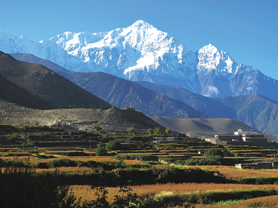
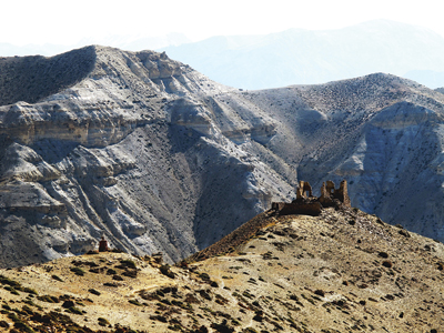
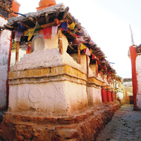
The topography here is dominated by a vertical escarpment of conglomerate geology. We were impressed throughout our trek by the twisted folds of steep, heavily eroded arroyos, and sandstone cliffs, many with caves cut into them. The wild arid landscape is also dotted with religious monuments (chortens) and occasional monasteries (gompas). The few villages in this extreme, virtually treeless place exist only where there are springs or small streams with water enough to irrigate one crop of buckwheat or barley per year.
Poplars and willows grow where it’s wet, and in a few places the villagers cultivate seabuckthorn berry bushes. Seabuckthorn juice is a popular sweet drink, known for its medicinal properties, rich in vitamins A, C, D, E and K, beta-carotene and omega-3 fatty acids.
The mules arrived ahead of us at Chele and our duffels were stacked neatly inside the Bishal Hotel for us to take to our rooms. The innkeeper and his wife were a happy couple who prepared a fine supper for us that night, and breakfast in the morning, topped off with fresh apples from their orchard.
Between Chhusang and Shyangbochen, about 18 kilometers on the map, there is no road. A link to the northern jeep track from Tibet is being bulldozed, and should be complete in a year or two. It is quite likely, however, that landslides and washouts will shut it down often.
“Mustang is perched on the brink of great change...” says the Lonely Planet guide. Blame the increase in foreign trekkers and near completion of the road. If you want to see Lo before its Tibetan lifestyle is fundamentally altered, go soon. There’s already electricity in most villages, cell phone communication, satellite TV, and modern consumer goods from India and China. But the new road will bring an advanced kind of ‘progress’—greater access to the outside world, new ideas and rising aspirations among the youth, and other inevitable transformations.
Early on Day 3, above Chele, we climbed up out of a deeply eroded canyon, then slowly ascended Taklam La (pass) followed by Dajorl La (11,900 and 12,254 ft., respectively), the first of 11 high passes.
At Samar we stopped for vegetable soup, chow mien and fried rice, the typical mid-day fare except on days when we packed boiled eggs and Tibetan bread for lunch. Rice, noodles, breads, and potatoes are the mainstay up here; vegetables and meat are scarce. In our day packs we each carried apples, granola bars, and a liter or two of water.
After Samar we crossed Bhena La (12,664 ft.) and Yamda La (12,664 ft.) then descended easily to Shyangbochen. Most settlements are small; often only one or two houses or hotels for tea-house trekkers like us, and a tenting ground. We spent the night in one of Shyangbochen’s two small hotels.
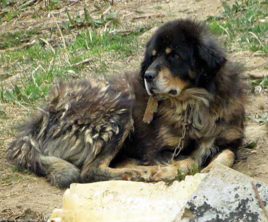
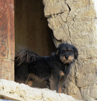
In the morning a Tibetan mastiff greeted us out front where he posed lazily for the dog-fanciers in the group (including me) to take pictures. At night the Tibetan mastiffs guard the compounds; their job is to bark loudly to repel intruders—people, animals, malicious spirits and ghosts—a bark that has described as “sepulchral and ‘far away’... as if each dog kept his own ghost in his stomach and it was only that ghost that barked.” It would be foolhardy to challenge their instincts by venturing outside after dark.
Nyi La, where Lo begins
Day 4. We crossed Shyangbochen La (12,631 ft.) this morning and Nyi La (13,156 ft.) in the afternoon above Jhaite, our lunch stop. From Nyi La north the culture is pure Tibetan. Most villagers up here also speak Nepali and some English (and Hindi, from watching Indian movies on TV).
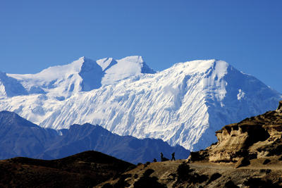
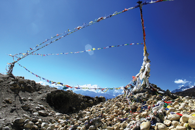
We had a magnificent view from Nyi La looking south to the Niligiri peaks and the north face of Annapurna-I. We worked our digital cameras overtime there trying to find a unique angle to frame the mountains between the brightly colored prayer flags that whipped wildly in the wind.
Later, after Ghami La (12,352 ft.), we descended to Ghami village, the third largest in Lo (after Tsarang and Manthang). We stayed at the Royal Mustang Hotel owned by Lobsang (‘Raju’) Bista, a grand-nephew of the Raja of Mustang. Originally, we had hoped to walk two hours to Dhakmar, but there’s no inn there large enough to accommodate our group.
For awhile I joined Raju in the hotel kitchen/living room, chatting and sipping suja, the traditional salt-butter tea that Tibetans serve to friends and special guests. Authentic “tea-house trekking of old” has been described where sitting “in the living room or the kitchen (often the same thing) you’ll eat, drink and be merry with extended family members, passing traders and the drivers of mule trains...” Genuine hospitality.
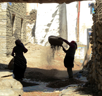
Then several of us went out for a village walk-about, admiring the freshly painted chortens and mani (prayer) walls, and looking for more of the famed Tibetan mastiffs of Lo. Early travelers often commented on the red dogs of Mustang. We found one out in a field where some women were winnowing freshly harvested buckwheat.
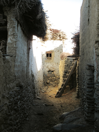
We also noted the common rammed earth style of house and monastery construction. Along the narrow lanes between houses we marveled at villagers precariously carrying huge loads of straw up notched log ladders to store on the flat roof tops, while small children rolled gleefully in piles of straw not yet hauled away.
Everything about Ghami indicated great industry and great age, with structures and customs dating back over centuries of isolation. There was no electricity, so the lights in Raju’s rooms were powered by solar cells mounted on the roof. We slept early that night in anticipation of tomorrow’s nine-hour walk to the walled city of Manthang, our ultimate destination.
Day 5 took us high on a long, tiresome trail under blue skies with broad, brown arid vistas. Above Dhakmar we ascended Mui La (13,681 ft.) past steeply eroded arroyos carved out by the wind and occasional violent cloud bursts. The map says that blue sheep may be seen near here, and Lo also has snow leopards, lynx, arghali sheep and wild asses. But we saw none. On most passes, however, Himalayan Griffon Vultures and Lammergeiers (Bearded Vulture-Eagles) soared close overhead. These giant birds have wing spans of up to nine feet.
The afternoon wore thin and wearisome as we trudged on and up, endlessly it seemed, towards the highest pass, Marang La (also called Chogo La; 13,878 ft.). We were now five days and almost 5,000 feet above Jomsom. It wasn’t far until we had a broad view of the plain of Manthang, the ‘Fertile Plain’ or the ‘Plain of Aspiration’, depending on which translation you prefer. Our destination, over an hour’s walk and 1300 feet down, was destination surrounded by barley fields and groves of poplar trees with (in October) leaves of gold. To the east and west were snow peaks with tongue-twister names like Nhubine and Chungen Changma Him
al, and Kekyap, Rijopuwa and Talung Danda. These high points mark the boundary of Nepal where it butts gently up into western Tibet.
It was late and with the sun low at our backs we followed our own long shadows into the ancient town.
Exploring Manthang
We stayed in the new part of town, outside of the walls, at the Mystique Himalayan Resort Hotel. It’s hardly a ‘resort’, but the nine rooms (two with attached baths) have sheets and woolen blankets on the beds (pure luxury!) and carpets on the floors, which keep the interminable dust down that otherwise permeates everything. There’s also a shower room with hot water (at no extra cost). The Mystique is written up in the Lonely Planet guide at $99 per room—but don’t believe it. Some rooms are only a few hundred rupees per night (less than $5), negotiable.
Ram Gurung runs the hotel, and also works at the local Annapurna Conservation Area Project (ACAP) office. He’s well connected with the local power structure, so if you want an audience with the Raja of Mustang, for example, Ram will fix the time and tickets, 200 rupees each. His wife and a helper do the cooking, and meals are served in a comfortable room that seats 12 to 15 people, near the kitchen. On cold evenings, a space heater burning yak dung chips takes the chill off.
We stayed two full days (three nights). On the morning of Day 6 we visited three monasteries, including a school for young monks. Had we come 10 days later, all the monks and school boys would have been gone to Kathmandu for the winter.
Two of our trekkers presented the school boys with soccer balls. After watching the rambunctious boys play dodge ball in the bright sun of the main courtyard, the school principal, Tsering Tashi, showed us the monastic museum. It houses ritual dancing costumes, numerous old monastic artifacts, and a large and priceless collection of ancient scriptures dating back many centuries to a time when this region was dominated by the pre-Buddhist Bonpo religion. Discovery of the rare Bonpo books is featured in a recent National Geographic Society film entitled ‘The Lost Caves of Mustang’. Nowadays, all Lobas (people of Lo) are Buddhist.
Chode Gompa is the oldest monastery, dating to the time of Lo Manthang’s first king, the legendary Ame Pal, around 1380 AD. Jampa Monastery, second oldest, is noted for ancient tantrik mandalas painted on the walls, and a large image of the Future Buddha, Jampa Chenpo, in a meditative pose. Thupchen Monastery was built during the period of the third king of Lo. The ceiling, walls, beams and rafters are covered in gold, silver and natural colors, and there are priceless images of Buddha and other deities in various poses.
Meeting the Raja
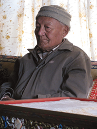
In the afternoon we had an audience with the Raja of Mustang, 79-year old Jigme Palbar Bista. His is the 25th generation since Ame Pal. Once an independent kingdom, upper Mustang was annexed to Nepal in the late 18th century and remained partially autonomous until 1951 when its status was further reduced. Today the Raja’s position is entirely honorary, though he is still held in great respect by the locals.
It is an honor to meet the Raja. Audiences are held in his sitting room at the top the palace, an old structure built and decorated in the Tibetan style. After climbing three steep ladder-like wooden stairways we entered his audience room. Following local custom, we each presented him with a silk khata scarf, which he, in turn, put around our necks. Then we sat sipping mint tea and politely asked a few questions about Manthang through an interpreter. Before leaving, we sat on the floor in front of (respectfully lower than) the Raja for pictures.
On the way out, several of us took a short detour to see the dogs. The Raja’s palace is guarded by two large black-&-tan Tibetan mastiffs. One is a normal do-kyi (‘door-dog’) and the other is a rare ‘bearded’ (hairy-muzzled) kyi-apso. They barked furiously at our intrusion.
The Raja also raises fine horses, which he enjoys riding. Until recently, it was the only mode of transportation in his kingdom, other than walking.
In one alley of the maze that makes up the inner city we found a sign that read “?Way to Viwe Top” (sic), where an old man guided us up for a rooftop “viwe” of old Manthang.
Next morning, Day 7, the team rode off on rented ponies to visit the spectacular caves of Garphu, 6-7 miles north of town. The caves are easily accessible and impressive. When he got back, one of the riders exclaimed: “That was one cool trip. Awesome!”, but complained of a sore backside from straddling the small, hard Tibetan style saddle.
There are numerous souvenir shops in Manthang, mostly inside the walls by the palace. The local ACAP office has maps, brochures, Internet access and local advice for visitors. Outside the walls there are many provision shops with all manner of goods imported across the Chinese (Tibet) border a few miles north of town. And, here in rapidly globalizing Lo, there’s another ‘Illy’ coffee shop run by the same family as the one in Kagbeni. There’s also a community library, Internet café, and several small restaurants, tea shops and bars. Everyone we met was friendly, though some asked us not to take their pictures.
Walking out
On Day 8 we set out on the return portion of our trek, first over Lo La (12,959 ft.), then all afternoon down to Tsarang (the second largest village in Lo). We stayed in Maya’s Hotel, Maya being another of the Raja’s relatives. A big attraction in Tsarang is an old Gompa partly in ruins. We could have spent several days exploring, but time was short.
The next day when Santosh phoned ahead to reconfirm our rooms in Ghiling, they were already taken. So much for advance reservations! That forced us to make a major change of plans requiring a longer, harder day’s walk. After crossing Chinggel La (also called Tsarang or Dhoya La; 12,697 ft.) we rejoined our previous trail at Ghami. On the way we passed upper Mustang’s longest mani-wall, which our most hi-tech trekker with GPS device determined to be 0.19 mile long. Long enough.
Our destination now was Shyangbochen, which some of us reached late and exhausted. It got dark quickly, so after a few beers and another high-carb dinner, we were off to bed.
On Day 9 the team split up temporarily. One group followed the regular trail back over Yamda La and Bhena La to Samar. A smaller group detoured down valley to Rangchung Cave Gompa where it is believed that Padmasambhava once meditated. Padmasambhava is the Indian sage who brought Buddhism to the Himalayas in the 8th century AD, after defeating the spirits of the pre-Buddhist Bon religion (according to legend). The cave has wall carvings of many deities, and an image of the revered sage. One of the trekkers remarked later that she felt a special, calming atmosphere there, and could understand why it’s considered sacred to Buddhists.
A deaf elderly man looks after the cave, opening it for visitors and collecting the 100 rupee entrance fee. He lives nearby, alone, with a little dog for company. He grows a small vegetable garden just outside the cave, which is festooned with numerous brightly colored prayer flags.
After their visit, the group climbed for 90 minutes up and over a high ridge, then rejoined the main trail. By evening we were all back together, at Samar’s Annapurna Hotel.
Behind the hotel in Samar is a large terraced garden with many trees, a small stream, and a black mastiff chained to a sturdy post. During the 1960s, during the clandestine war of resistance against the Chinese occupation of Tibet, a large contingent of Khampa guerilla fighters lived here. Standing in the garden, I tried to imagine them with their horses and guns, preparing to set off on a raid against the PLO across the border. In 1971, as the USA pursued diplomatic relations with Beijing, CIA support to the Khampas ceased. Shortly thereafter the guerillas (growing old) were disarmed and resettled at cheese factories and in carpet factories around Nepal.
On the 10th morning, our last day inside the restricted area, we set out at 5:30 am, hoping to reach Kagbeni before of the daily dust storm. We stopped to eat a quick breakfast in Chele, then scurried on. By early afternoon we were safely inside Kagbeni’s Paradise Lodge, out of the wind. The following day we were back at Om’s Home in Jomsom, and the morning after that we flew out to Pokhara and back to Kathmandu.
Mission accomplished. I’d achieved my 48-year quest. We 13 trekkers, some in our 60s and 70s, were back from upper Mustang with no complaints more serious than sore feet and runny noses. Were we among the last to see what remains of the region’s rich and unique Tibetan culture? Perhaps not, but when the road is done upper Mustang of old will certainly see “great change” and a new reality. It’s already begun, so if Lo on your list ‘to do’, do it now. Go soon...