A mountain bike ride on a historic trail offers fantastic vistas and amazing displays of warm Nepali hospitality.
Yes, an ancient trail it was. Long before the dawn of recorded history, pilgrims, monks, royalty, foreign dignitaries, warriors, traders, and common people alike trod this path to and from the Valley of Nepal (Kathmandu). In fact, it was the only route that connected Nepal with India. Christened by some as the “Rolls Royce” trail, since the first ever automobile (in 1934), and subsequently others ridden by the capital’s royals and aristocrats were transported by this route--not on wheels but shouldered by porters. Much to my surprise, even my mother, an octogenarian, recalled having journeyed this route to India and back, some 66 years ago. Then, in 1956, the hustle and bustle that marked the villages along this route came to a grinding halt. That year, the Tribhuwan Rajpath, the first ever highway to link Kathmandu with the Terai, to Birgunj and Raxaul, across the Indian border opened. All too soon the old dusty footpath between Kathmandu-Thankot and over the Mahabharat hills via Chisapanigadi and Bhimphedi, was forgotten.
Khashing and I planned to explore a portion of this historic path southward from Thankot, traversing beautiful villages like Chitlang, Markhu, Kulekhani and Phakhel--not on foot like our venerable ancestors did but on two wheels—mountain bikes. We could hardly wait to set off.
Struggling start
Negotiating traffic snarl-ups at Kalanki and dodging convoys of heavy vehicles that bore down on us, the first leg to Thankot proved rather sluggish. At Thankot, we left the main highway and followed a narrow paved road on our left from the police post past a jumble of houses that served as shops. We were spared the highway traffic from this point onward. After a half hour uphill ride on a paved but pitted road, we stopped for lunch at Godam as we learned no eatery appeared from there on to Chitlang.
After dal-bhat and a short rest, we filled our water bottles and started uphill. After Panighat, the road turned into a jeep track, which got steeper and rockier as we headed into the forested hills towards the 2,265m Chandragiri ridge. We felt a chill in the air as the sun receded further and the hills closed in above us. The steep gradient gradually took its toll on me--but Khashing who is less than half my age (59), took it all in stride. As I stopped to regain my breathing, I spotted women laden with huge piles of fuel wood descending. The old lady was taken by surprise when I asked her about the load (she took us for kuires: white-skinned foreigners). “Fifty to fifty-five kilos”, she answered, a grin spreading across her fine wrinkled face. And there, I was struggling for breath with a five kilo back-pack!
 In the lap of nature
The more we climbed, the denser the forests got. Tall pines spiraled tightly up into the high hills. The luxuriant vegetation appeared like a close-woven carpet of pale green and olive, while a sprinkling of Chilaune trees (needle wood) of autumn magenta foliage lent a floral motif to the pattern. The climb continued relentlessly—even the “granny” gear did not work. I had to dismount and walk my bike. Khashing, too, got off on steep gravelly switchbacks. Join the club buddy!
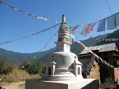
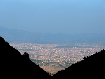
Several spots on the hill offered bird’s eye views of Kathmandu valley—once a fertile bowl, now a jumble of concrete—basking in the afternoon sun. It took us a grueling three hours from Godam to crest the Chandragiri ridge (Mountain of the Moon) locally called the Chitlang Bhanjhyang (pass), atop the Mahabharat range. Dusk approached, as we stood on the cold windswept ridge. On our left two wooded hills undulated across the horizon, Bhaleswor and Tare Bhir. A dirt road went right towards Toplang (Tamang village). Buddhist chaityas (religious monuments) and a Hindu shrine stood by the pass.
The North opened with an arresting sight of lofty snow-capped Himalayas. On a clear day, the Chandragiri ridge offers a great view of Ganesh Himal, Langtang, Dorje Lakpa, Gaurishankar, and others, all the way to the mighty Everest. Kathmandu valley appeared below, on our east, like a massive amphitheatre surrounded by dark hills. It is said that King Prithivi Narayan Shah once stood on this pass and contemplated his initial assault on Kirtipur( (Dec 4, 1757).
 “From the summit of Chandraghiri there is a most commanding prospect, the eye, from hence, not only expatiating on the waving valley of Nepaul, beautifully and thickly dotted with villages, and abundantly chequered with rich fields fertilized by numerous meandering streams; but also embracing on every side a wide expanse of charmingly diversified country.” --Col. William J Kirkpatrick, An Account of the Kingdom of Nepaul (1811).
To our south the ridge dropped to the narrow Chitlang valley. We could make out terraced fields and scattered clusters of tiny looking houses framed by forested hills, turning into dark masses in the faint light as the sun slid below the horizon.
We soon put the lights on as we freewheeled down the bumpy track. A half hour brought us to the valley. We pedaled along the dark deserted road heeding large stones, and shallow trenches used for irrigating fields. Soon, to our great relief, we saw lights and were acknowledged by a group of men chatting away at a shop. One of them even offered to take us to a home-stay within spitting distance.
Our arrival at the home-stay was followed by sharp barks of dogs. The first to receive us were ‘Michael’ and ‘Jackson’—a pair of pet dogs. We felt like VIPs as the host offered us tika and garlands before being shown to our room. With a little haggling the tariff came down to earth—400 rupees for supper, bed and breakfast (normally Rs. 650.00 for foreigners). Tired as we were, nothing could be more welcome than a hot meal and a warm bed. We wasted no time.
 Open countryside
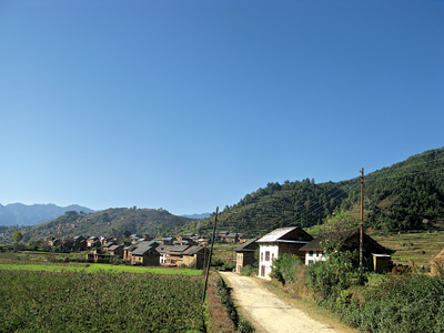
The next morning was crisp but gloriously sunny. From where we stood, thick forests blanketed the hills to the North, East and the West, while to our South the view spread out into expanses of terraced field; a road passed through the middle. Small pockets of houses, mostly stone-roofed, were scattered around. In the mid-November morning, the rustic landscape appeared like a freshly done painting, still on the easel.
“...the sides of the hills [on] the upper part of the Chitlong valley... [are] well-wooded, and abound in a vast variety of wild shrubs, forming altogether a very pleasing sight...” Col. Kirkpatrick.
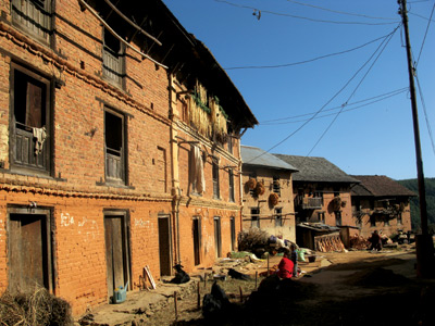
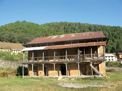
 While Khashing busied himself taking pictures, I struck up a conversation with some teachers who’d stopped for tea. I learned that the three crumbling buildings within the nearby school premises were built by the Rana Prime Minister, Chandra Shumsher (the fifth Prime Minister of Nepal, 1901-1929). The buildings once served as guest houses for Rana elites who stopped for the night on their journey to and from India, well before the motor road (Tribhuwan Rajpath) came.
“The hills covered with forests are protected community forest. We have quite a temperate variety like pine, chilaune (needlewood), phanlat (oak), lapsi (renowned for its small fruits called hog-plum), utis (alder), and katus (chestnut)”, said Dhruba, a teacher, satisfying my curiosity about the lush vegetation.
After breakfast our host, Rita Singh Thakuri, took us on a tour of her goat cheese factory. Chitlang is the first village in Nepal to produce goat-milk cheese (under French technical expertise). The cheese, soft and hard, sells for between 1,500 and 2,500 rupees per kilo in star hotels and restaurants of Kathmandu. We also visited the goat farm that she and her husband, Ashok Singh Thakuri run.
After a customary check and dusting of our bikes down, we took leave. With “Pheri pani aunus, hai” (please visit again), our smiling host bid us good-bye.
 Steeped in history
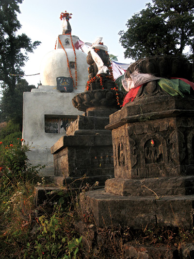
First, we stopped at an old settlement called Majhgaon, an ancient Newar village, which housed the renowned caitya built by Emperor Ashoka of India. It is believed Chitrapur (ancient name of Chitlang) was renamed Chaityalon, caitya (monument) and lon (path) in Newari, after this monument. Over time, the name got misquoted as Chitlang. We had a strong feeling of déjà vu as we walked our bikes through narrow alleys. It suddenly struck us that we were somewhere in the outer reaches of Bhaktapur. The men and women too, looked familiar — men in their suruwal (tight trousers), shirts, waistcoats, and the ubiquitous black Bhadgaunle topi (the national cap), and women in cotton checkered blouses and black fariya (traditional dress) with red borders. They were the Balamis (ethnic Newars). Myth has it that Bala (middle) and mi (person) got their name when a child was born in the middle of a road amongst their community as they travelled out of the Kathmandu valley, deported as they were by the king of Bhaktapur for having contracted small pox. I spoke Newari to some and was answered back in Newari—very similar but contrasting to the Kathmandu dialect in the choice of words.
 Chitlang is predominantly populated by the Balamis and the Gamals, another major Newar community. The Gamals (people from villages in Newari), who once served the royal kitchen in ancient Bhaktapur and Patan, were ousted for misconduct by the Malla Kings from the Kathmandu valley to live in the villages. Other ethnic minorities in Chitlang include Brahmin and Chhetri. Full of rich Newari culture and believed to have descended from the ancient Kathmandu valley, Chitlang hosts similar Newari festivals, the Kartik Nach (the legendary dance performed in Patan, Lalitpur in Oct-Nov) being a popular one.
The Ashoka caitya in Majhgaon bore a stone inscription that dated back to Sambat 45 of the Lichhavi Era (between the 5th and 8th centuries AD), proclaiming Udayadev as the king of Chitlang. Next, we visited the perennial Sat Dhara (literally, the seven stone waterspouts)—the main source of water to a number of settlements.
As we left Majhgaon, the main village road, although past 10 am, appeared deserted. There were no vehicles other than a handful of motorcycles, and hardly any people. It seemed unreal. “The village path bustled with life and trade flourished in the old days,” said Buddha Ratna Manandhar, a retired school head-teacher. “I was eight years old when my friends and I used to play pranks with the vehicles that were being lugged by the bhariyas (porters) on the busy street,” reminisces a nostalgic 75-year old Babukaji Manandhar. Of the many porters, mostly deceased, one Hiraman Balami—now in his nineties - lives to tell his tales. We missed him as he had moved to a far-off village called Khadpu.
A little later, we saw men and women working their fields in the distance. The fields stretched away in a blaze of green and yellow - young crops of wheat and mustard in full bloom. We sighted our first truck at Narayanhiti, named after a shrine of god Narayan (Bishnu) and a stone spout. We continued past quaint little dwellings at Tibikhel and Kushlechour; a small rivulet called the Chitlang kusi (river in Newari) ran alongside the road.
After a half hour’s ride on the quiet road, we learned that we had taken the longer route to Toukhel missing behind the commonly used road at Narayanhiti. “Not to worry, as long as you stick to the road and take the right fork a little way downhill, the left path goes to Markhu,” a local farmer offered advice. We regretted later that we had missed the historic kot (fortress) built by the Malla Kings—only old bricks and some artifacts remain—located on a hilltop on the shorter route.
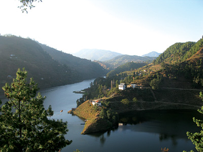
The ride was very quiet, with no souls in sight as we freewheeled down a steep hill through a thick pine forest. Soon the fork appeared; wow! The openings between the woods allowed us our first glimpse of the turquoise waters of the Indrasarovar (the Kulekhani reservoir that feeds the Kulekhani hydropower plants). The reservoir ran almost parallel to the gravel road for a while.
Timeless culture and heritage
Toukhel (6 km from Chitlang), is predominantly resided by the Gopalis, yet another ethnic Newar community. I could not understand a word of it when I heard them speak. The Gopali dialect is different from the Balami or Gamal tongue—and not even remotely close to Kathmandu Newari. The Balamis, Gamals and the Gopalis, all Newars, live in such close proximity, but when it comes to their language, they are a world apart.
Rudra Gopali, a teacher at the local school, offered to take us around the village. “Toukhel (a big ground) is exclusively resided by the Gopalis, descendants of the Gopal era (before 300 A.D.) and milkmen or cow herders by origin,” informed Rudra us. “The people of Toukhel depend on agriculture and livestock,” he explained. As we continued our tour, we noticed old houses with carved windows; some had shutters reminiscent of neo-classical architecture. The entire setting again, like Majhagaon, captured the quintessence of old Madhyapur Thimi or Bhaktapur. Neat piles of straw, masticating buffaloes, men going their ways with their kodalis (digging tools), women tending to rice paddy laid before their houses to dry in the sun, bunches of chilies, corn-cobs and long strips of sliced radish hanging by the roofs—all showcased a traditional and timeless past.
Next, we visited an ancient stone inscription dating back to the Lichhavi era. According to Rudra, the inscribed words were an appeal made by their ancestors to King Amshuverma (6th century AD) to move residence to Toukhel instead of to far off, dreaded forests where they originally belonged. It is also said that King Udayadeva (621 AD), the then King of Chitlang, donated the present land to the Gopali community. Nearby villages included Bisingkhel, Nhulgaon and Kunchhal. As our tour neared its end, Rudra pointed to a distant clump of trees, which he explained was the jaitun (olive) oil extraction center set up by the German government.
 Picture perfect
Next leg: Markhu. The hillside small bazaar overlooked the beautiful Indrasarovar lake. The place boasted an old durbar building (a palace) built by the Rana Prime Minister Juddha Shumsher (1932-1945), which in the olden days put up travelling Rana nobility, for the night. The building today serves as a government guest house. After the clutter of roadside shops and tea houses, the landscape changed. We suddenly found ourselves amidst tall, evergreen pine trees, with the hills around dotted with small houses and terraced fields that dropped to the man-made lake—a picture postcard setting.
I quietly gazed down at the vast expanse of water, musing on the fate of many old villages that lay there deep in their watery grave (500 families were displaced). A local fellow told me that the suspension bridge built by Chandra Shumsher, which people crossed while doing the ancient route too were submerged when the reservoir was built and flooded in 1983.
Markhu is known for a local delicacy — fresh fish from the reservoir. “People from Hetauda, Birgunj and as far away as Kathmandu, make frequent visits to savor the fish, canoe the serene waters and relax out in the serene ambience,” informed Ram Prasad Pradhan, the owner of Indrasarovar Hotel.
After a nice meal and a little rest, we headed South East towards Phakhel. The jeep track got better as we freewheeled past Shimle, enjoying the woods, and the terraced hillsides. The Indrasarovar lake kept company until Kalanki, a cluster of tea houses perched on a hillside that sharply dropped to the Kulekhani dam at the base. We stopped briefly for tea made with buffalo milk (loved it!) and a little snack. The road led to a fork at Kalanki; to the right was Bhimphedi (the last point on the old route, where the trail walkers of old used to catch a lorry south to Birgunj on the Indian border), while the left was Phakhel, due East. We parted company with the ancient track at that point.
The ride to Phakhel was a moderate climb with some steep inclines thrown in. Darkness soon crept in as we sped past tiny settlements called Salle and Sukaura. As the shadows lengthened, the road that continued along a deep gorge appeared pretty dicey at narrow sections. Lights appeared in the distance. Phakel, at last!
We were expected at Phakhel. Kumar Lama had not only arranged for our night-stay but had taken a lot of trouble in preparing a lavish dinner for us! The pre-dinner chat warmed as Kumar and I (Khashing abstained) helped ourselves to jhwainkhatte (local millet alcohol poured into a sizzling pan of rice grain fried in ghee) served by Kumar’s wife. I felt my exhaustion cut down by half by the wonder drink.
Where the wild roamed
“Fa (wild boar) and khel (pasture) stands for a place where once the wild boars roamed,” explained Bir Bahadur Lama, an elderly man from Phakhel. The local folklore has it that Lord Shiva, accompanied by a pair of dogs on a hunting trip shot his bow and arrow at a huge boar that turned to stone. The stone figures of the wild boar and the dogs are still to be found in Phakhel. The idol of Shiva, as Kumar told me, lies at Latrambeswor hill, a four-hour walk from Phakhel.
The morning’s tour took us around a predominantly Tamang ethnic village. Another Tamang village, Chakhel lay close by. It is believed that a local king ruled the tiny villages before Prithivi Narayan Shah’s unification of Nepal. We stumbled across old lumps of bricks said to be the ruins of the old kingdom. Said Kumar, “Previously dependant on maize and millet, the villagers have switched to vegetables and flowers.” Interestingly, almost the entire Tamang community of Phakhel has a history of working in the food line. Little surprise if you bump into Tamangs from Phakhel in one or the other star hotels and restaurants of Kathmandu. Forty-seven years in the food line, 63 year old Prem Lama started his career as a dishwasher, and rose to the level of executive chef in a star hotel in Kathmandu. More recently, there has been a mass immigration of local youngsters to the Middle East and South Korea for work.
It looked like hospitality knew no bounds in Phakhel. Dheeraj Lama, brother of Prem Lama, offered us free lunch at his hotel, Tashi Delek. We left Phakhel in the afternoon, much obliged to Kumar and other folks of Phakel.
It took us a one-half hour hard slog to the 2100m Humane Bhanjhyang. We spotted a group of tourists busy clicking at the spectacular view of the Kathmandu valley the ridge offered, the snow-covered mountain chains providing a dramatic backdrop. We followed suit. I learned the names of some of the peaks from the tour guide who accompanied the group: Langtang, Langtang Lirung, Dorje Lakpa, Purbi Chachu and Buddha Himal.
 Back home
The downhill track from Humane to Chhaimale felt deserted as we rode past forests, terraced fields and thin habitation. At some sections, the track narrowed into a single trail caused by landslip. At Chhaimale, we met a paved road, and, much to our dislike, Tata Sumo jeeps that roared past virtually every minute. Having done a traffic-free two days, riding the hectic road after Chhaimale and Dakshinkali proved a tricky business — sheer torture when we hit the city hub—and totally disoriented as we headed back home. But then my thoughts turned to the fantastic getaway and I felt elated at having done some justice to our ancestors’ track as old as the Mahabharat hills.
The Chitlang-Markhu-Kulekhani-Phakhel circuit is a well-used track by mountain bikers (95-100 km round trip). Recent times have seen hikers both foreign and Nepali frequenting the route. Buses and public jeeps can be intercepted, if need be, on Phakhel-Pharping, and Chhaimale-Dakshinkali road. For accommodation, basic lodges, home-stays, tea houses and eateries are to be found fairly well on the route. You can also travel by a 4×4 motor-vehicle.
The author can be contacted at mansinghravi@gmail.com