Foreigners visiting Nar-Phu valley require a special permit and must travel with a fully-outfi tted guide service. For these reasons, Nar and Phu are the goal of only the most adventurous. It’s always been that way – isolated, little-known, physically demanding, and out of the way for most trekkers.
The first foreigners reached Nar and Phu in the early 1950s. What they saw can be read today in old travelogues that de-scribe a high arid valley of a few hundred inhabitants living in two small villages, surrounded by crumbling ruins, sacred sites, herds of yak, wild sheep, and some of the highest snow peaks and most diffi cult trails in Nepal. Nar is at 13,642 feet, and Phu, a few days walk farther north, is at 12,992 feet. Between them are the winter villages of Meta and Chako (belonging to Nar) and Kyang (of Phu). The hardy villagers regularly descend to their winter villages for a few months to escape the harsh cold higher up, though to outsiders the differences in altitude and climate may seem negligible.
The Nar-Phu ancestors settled in this isolated valley from Tibet generations ago. Today, life focuses on farming, yak herding and trade. The traders go south in winter, into the mid-hills, or to India, and some-times as far as SE Asia. The yak herders, men of Nar, manage herds belonging to their wealthier neighbors over the 17,408-foot Kang La in upper Manang. The farm-ers raise hardy high altitude barley, wheat and buckwheat. And, today, there is another factor: Nar-Phu youth going to Kathmandu for school, jobs, modern amenities and a lifestyle unachievable at home.
Until recently (the past few decades), access to the Nar valley was controlled by the seasons. The low trail up the Nar river was treacherous, and open only during the winter months. In the space of one day, travelers crossed 22 wooden bridges, often in poor condition. During the rainy season, some were disassembled to save them from being swept away by the raging torrent in fl ood. Then, only the high route above Nar village over Kang La was open. Nowadays, a few permanent steel bridges have replaced all the old wooden ones, and the river trail, much improved, stays open year round.
Early Western Travelers To Nar And Phu
The inveterate mountaineer, trekker and writer, H.W. ‘Bill’ Tilman, was the fi rst Westerner to visit Nar and Phu. He was, in fact, one of the fi rst foreigners allowed to travel anywhere in the hills beyond the Kathmandu Valley. In 1950, he trekked around Annapurna through Manang and over Kang La into the Nar-Phu valley.
In Nepal Himalaya (1952), Tilman de-scribed Nar (Naurgaon) as a village “suf-fi cient unto itself without making much use of this fi ne valley. Poised high above the Naur river, the village surprised us by its comfortable and prosperous air. The houses, as usual, appeared to grow out of the brown, stony hillside, while below lay terrace upon terrace of young barley of the liveliest green where a swarm of women and children were busy weeding. We camped short of the village by a brook, its grassy bank fragrant with thyme...”
A few days later, Tilman’s party set out to go climbing. The trail took them down 2,000 feet into the Nar river valley then up into the mountains on the east side. On the way, they passed through an empty village (Meta), where wheat and buckwheat were growing in the fi elds. It was some days later before they returned to the riverside trail and set out north to Phu (Phugaon).
The approach to “the strange village of Phugaon”, wrote Tilman, is up a series of gorges “negotiated by means of stairways hewn out of the rock”, then through a unique gateway. “Having climbed several hundred steps up... we had to go through a wooden gate topped with small chortens, and past a red, white and black mani wall.”
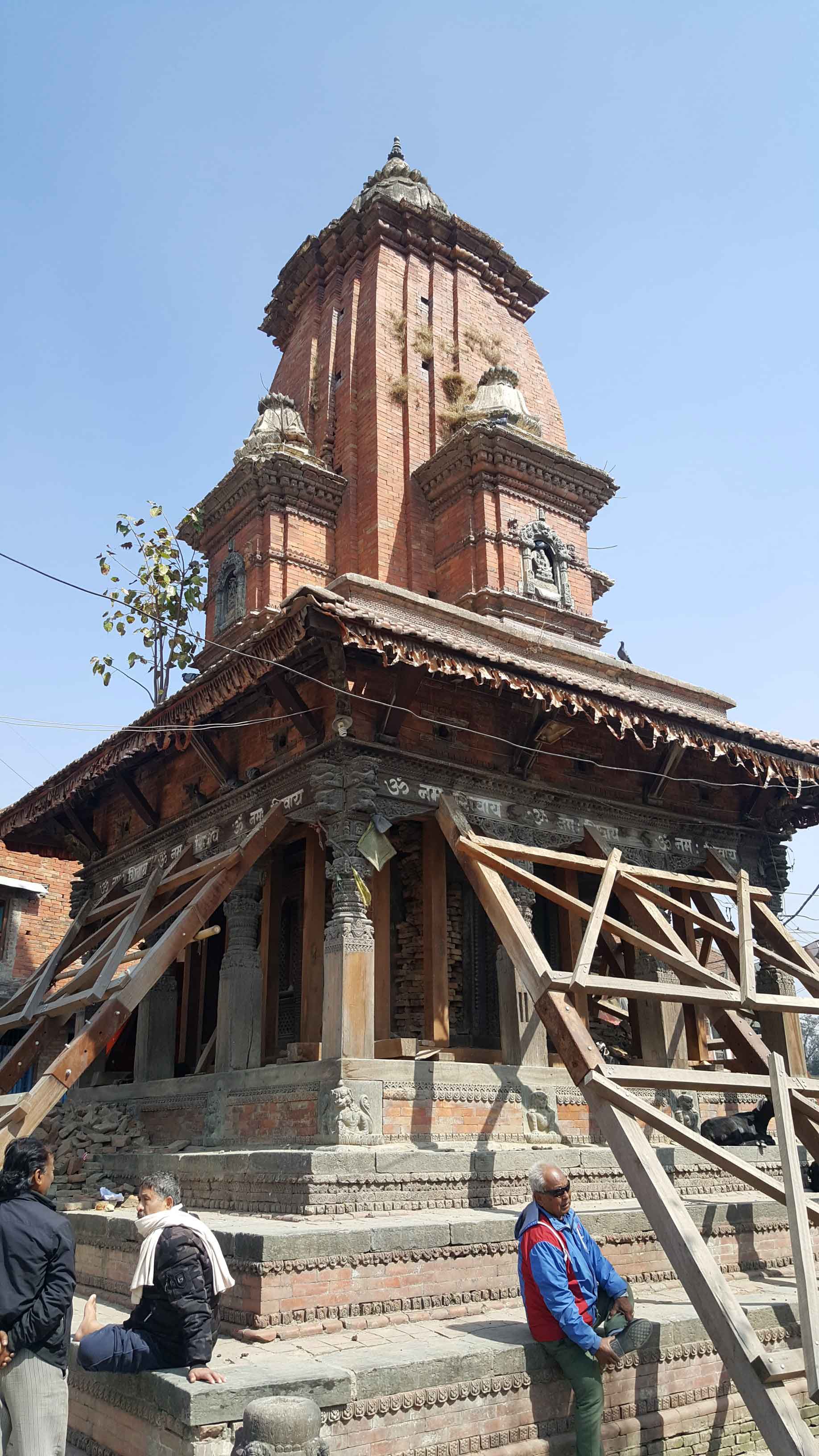
All around were signs of an earlier era, in ruins. “Here there were several large coloured chortens, and above them a ruined tower high upon a rock pinnacle guarded the defi le” – remnants of a time, centuries ago, when the petty warlords of this region waged war on one another. When David Snellgrove passed this way four years after Tilman, he noted, “In the days of bows and arrows this upper valley must have been safe from all foes.”
Of Phu, Tilman wrote: “At fi rst glance it appears to consist of nothing but nar-row, clay threshing fl oors supported on pillars, underneath which the chaff and grain are stored when winnowing. There are, in fact, some hovels behind these but the best houses are assembled under one roof, and surrounded by a single wall on the summit of the cliff...” He also saw a small white gompa (Buddhist monastery) and a line of 13 chortens (reliquaries) on a hill across the valley. “Such are the austere features of a harsh landscape,” he concluded, “where hardly a shrub grows, much less a tree; a landscape of yellow cliffs, white granite boulders, and the grey ice of the glacier...”
Tilman and his companions were mountaineers, more interested in peaks and passes than in the local way of life. After leaving Phu, they crossed an un-named pass west into Mustang District, somewhere near Muktinath.
Tibetologist David Snellgrove visited Nar-Phu in 1954, as a brief side trip during a seven-month research journey along the Himalayas. His main interest was Buddhist religious practices, which he described in Himalayan Pilgrimage (1961). Of Phu, he said virtually nothing. On arrival, he went directly to the hill-side monastery, the Tashi Gompa, and spent all night observing an elaborate ceremony celebrating the ‘tranquil and fi erce’ divinities. The next morning he was back on the trail to Nar.
Not until Windsor Chorlton came do we get a true picture of the remarkably medieval village of Phu and its impreg-nable position on a cliff above the river. Although most of Chorlton’s book, Cloud-Dwellers of the Himalayas (1982), is about Nar, his relatively short description of Phu is quite good. “The village,” he wrote, “looked like a tiny fortress-citadel. For defence against bandits and to avoid wast-ing a single square foot of scarce arable land, it had been built on a 100-foot rock outcrop that fell sheer to the banks of the river. Most of Phu’s 38 houses clustered on top of the outcrop or clung to its sides like swallows’ nests; but a few spilled over a neck of land that joined the mountain behind the village...”
He entered the citadel “through a door that, in bygone days when Tibetan brigands menaced the valley, used to be shut and locked each evening.” I’ve stood in that entryway, and can vouch for the size and heft of that great wooden bar-ricade. My host showed how it could be shut tight against marauders, locked in place by a huge bar hewn out of a stout log. I was impressed, knowing that all the big timbers used in Phu, for doors, windows and house frames, is carried up from the forest over two days away, downriver.
Chorlton went on to describe the dark, condominium-like interior of the citadel. “Because building space was so limited, many of the houses stood four storeys high, with one family occupying the lower fl oors and another the upper levels.”
Then, we learn something about daily life, tradition and respect for the ancestors. As Chorlton threaded his way through tiny alleyways and up and down ladders linking one dwelling to another, he emerged into courtyards “where men and women sat busily threshing grain, weaving blankets and making boots.” He found them “lively, friendly and cheer-ful” considering “the comparative harsh-ness of their surroundings and the even greater paucity of their resources.”
They described their hardship, and winters so bad that they had to abandon the village and move down valley for a few degrees of warmth. In winter “nobody stayed in the village: old people who could not walk were carried to Kyang,” they said. When asked why not move to a more hospitable place, they laughed. “This is the home of our ancestors,” they said. “We would not want to abandon it.”
I visited Phu in 2002, and found that most villagers now live in sturdy houses outside of the crumbling citadel. Each evening, I chatted with my host in the windowless interior of his home, warmed by a smoldering fi re in the open hearth. An overhead bulb, powered by a solar roof panel, gave us light. Many houses had solar lights, the only modern convenience besides battery-powered radios that I saw there.
Each dawn I awoke to total silence – no dogs barking, no roosters crowing. Puzzled, I asked, and was told, simply: “We have none.” Perhaps it’s too cold for chickens, or the locals don’t want to pack poultry and pups back and forth to Kyang. The only dogs we saw were big black mastiffs accompanying the yak herds.
While he was there, Chorlton climbed above the village for a commanding panorama. “From where I stood,” he wrote, “I had a bird’s-eye view of the vil-lage and its setting. Several hundred feet above Phu, a few families were ploughing fi elds so steep that I held my breath each time a team turned at the top of a furrow, convinced that the yaks would lose their balance and topple backwards on the man straining to hang on to the plough.”
Then, his gaze turned eastward: “On the other side of the valley, tiny fi gures were inching along a trail towards the north, where Phu’s main yak pastures and summer settlements lay.”
The Tashi Gompa sits high on a bluff with “a fi ne view of the glittering peak to the north...,” he wrote. “Such sites are deliberately chosen: gompa means ‘a solitary place’, where priests and monks can meditate without distractions. But the Tashi Gompa was also a reassuring symbol of protection, for the villagers had only to look across the valley to see its prayer fl ags whipping and cracking in the wind, offering defi ance to invisible foes at the four corners of the horizon.”
As a footnote to the travelogues, dur-ing the 1960s, Tibetan guerillas entered the upper Nar-Phu valley to camp. These armed Khampa resistance fighters settled in Chako and Meta, safe from the Chinese. They stayed well into the 1970s before the Nepal government disarmed and resettled them elsewhere. But the Khampas wrote no travelogues; the only printed record is a signboard at Meta commemorating their stay.
Trekking To Nar And Phu Today
Traveling to Nar-Phu today is relatively easier than in the past, so long as you follow the rules. All foreigners must hire a registered trekking agency to go fully outfi tted, complete with a Sardar, porters, cook, fuel, food and tents. Each trekker must carry an entry permit to show at checkposts ($90 in trekking season, $75 in the rainy off-season). An Annapurna Conservation Area permit is also required (2,000 rupees; double that if you wait until Manang to buy it; South Asian nationals pay less).
Access to Manang District is either on foot or by plane. During the trekking sea-son, when the airfi eld at Humdé is snow free, planes fl y up from Pokhara on a fairly regular basis (or by pre-arranged charter).
Trekkers are best advised, however, to walk into Manang, to assure proper acclimatization. If you are on the 21-day Annapurna circuit (Besisahar-Chamé-Braga/Manang-Thorung Pass-Mukti-nath-Jomsom-Pokhara) and want to see Nar and Phu, add at least seven to nine days to your itinerary. And be sure you have the permits, are well supplied and are in good physical condition.
The trail to Manang used to start from Besisahar, in Lamjung District. Nowadays, it begins from the end of the new motor road. When I was there in 2009, vehicles could drive up to Syangé at the mouth of the Marshyangdi river gorge (saving a day’s walk). The trail shortens each year as the motor road advances farther north. Soon it will reach Tal, where a hydro-electric power project is under construc-tion. In the past, Tal was at least two days’ walk from Besisahar. Koto and Chamé, the district headquarters town, are another two days’ walk beyond Tal. (Times may vary, depending on the trekking party, trail conditions and weather.)
The low trail into Nar-Phu takes off north from Koto. The fi rst day on the river trail is through a picturesque forest of mixed conifers and deciduous trees, with some spectacular glimpses of the high peaks far overhead. Be wary in rain or snow, however, for the trail can be-come treacherous, with dangerous land-slides. I know well, for in 2007, the trail was closed for over a week by torrential rains and washouts, and my 2009 trek was stopped cold – quite literally – by an unseasonal three-day blizzard. Both times, our groups proceeded on into up-per Manang where we enjoyed exploring cultural sites and side trails, before fl ying out to Pokhara and on home.
Early travels to Nar and Phu are described in: Tilman’s Nepal Himalaya (1952; reprinted in The Seven Mountain-Travel Books, 1983); Snellgrove’s, Himalayan Pilgrimage (1961) and Asian Commitment (2000); and Chorl-ton’s Cloud-Dwellers of the Himalayas (1982). See also: Liesl Messerschmidt, et al, Stories and Customs of Manang (2004); Clint Rog-ers, Secrets of Manang (2004); and Pradeep Pokharel, Manang: People and Places (2008).Don Messerschmidt (at don.editor@gmail.com) is a freelance writer and contributing editor to ECS Nepal. Vidya Hirachan of Mus-tang Trails, Trekking & Expeditions (www.mustangtrailsnepal.com) assisted with this article and managed the author’s last two group treks to Manang and Nar-Phu.