.jpg)
Glacial lake outburst flood (GLOF): “As glaciers retreat, lakes commonly form behind the newly exposed terminal moraine. The rapid accumulation of water in these lakes can lead to a sudden breach of the moraine dam. The resultant rapid discharge of huge amounts of water and debris is known as a glacial lake outburst flood (GLOF)—and the results can be catastrophic……”
Impact of Climate Change on Himalayan Glaciers and Glacial Lakes, ICIMOD, 2007
Prelude: We watched in awe as blackish, mud laden water was suddenly released from unseen caverns and cave systems within the debris-covered Lhotse glacier, Sagarmatha (Everest) National Park. The roar was deafening, and porters scrambled for higher ground as the flood waters from a dozen different outlets coalesced and plummeted down the glacier’s outlet toward the village of Chukung (5,500 m), threatening lodges, destroying bridges, and submerging anything else in its path (see: (https://av.tib.eu/media/31808). Crossing an ice bridge over the flood waters still raging below, we eventually made our way back to Chukung which, at least this time, was relatively untouched by this particular form of glacier floods originating from within the glacier itself.
Just one year later, while working in the same region, we heard that yet another flood had just occurred in the Arun valley to the east, with its source being the Barun river in the Makalu-Barun National Park and Buffer Zone. Was it the result of something similar to the Lhotse englacial conduit flood that we had witnessed and videoed the year before? Or a glacial lake outburst flood (GLOF), triggered by an ice avalanche that fell into the massive Lower Barun glacial lake at the head of the valley? Or maybe something as mundane as the result of heavy rains in the extremely wet Makalu-Barun region?
Only a visit to the remote Barun valley could tell
for sure.
The Langmale Flood: At 4:00 p.m. on 20 April, 2017, a mysterious flood from the Barun river in Makalu-Barun National Park formed a large lake at its confluence with the Arun River, directly above the village of Barun Bazaar (1,100 m)(Figure 1). Five houses and 5 to 6 hectares of agricultural land were destroyed in Barun Bazaar, and at least 80 families living within the immediate vicinity were threatened in the event of a sudden outburst flood. The lake also threatened downstream villages that included Phaksinda, Diding, Chetabesi, Lumningtar; other riverside communities in Bhojpur and Dhankuta districts, as well as the construction activities of the recently approved Upper Arun Hydropower Project directly below Num (1,560 m).
Government response was swift, deploying a team from the Nepal Army and Nepal Police to assist endangered people and to drain the lake if necessary. Fortunately, the lake drained spontaneously sometime between 20 and 21 April, 2017. Attempts to identify the source of the flood by the Nepal Army were thwarted when bad weather prevented a helicopter reconnaissance of the upper Barun region. Speculation regarding the cause and source of the flood ranged from heavy rains, to flooded tributaries of the Barun, to a glacial lake outburst flood (GLOF) from the Lower Barun glacial lake, the latter containing more than 74 million cubic meters of water and considered to be one of Nepal’s most dangerous glacial lakes. But without any firsthand observations or evidence, nobody
really knew .
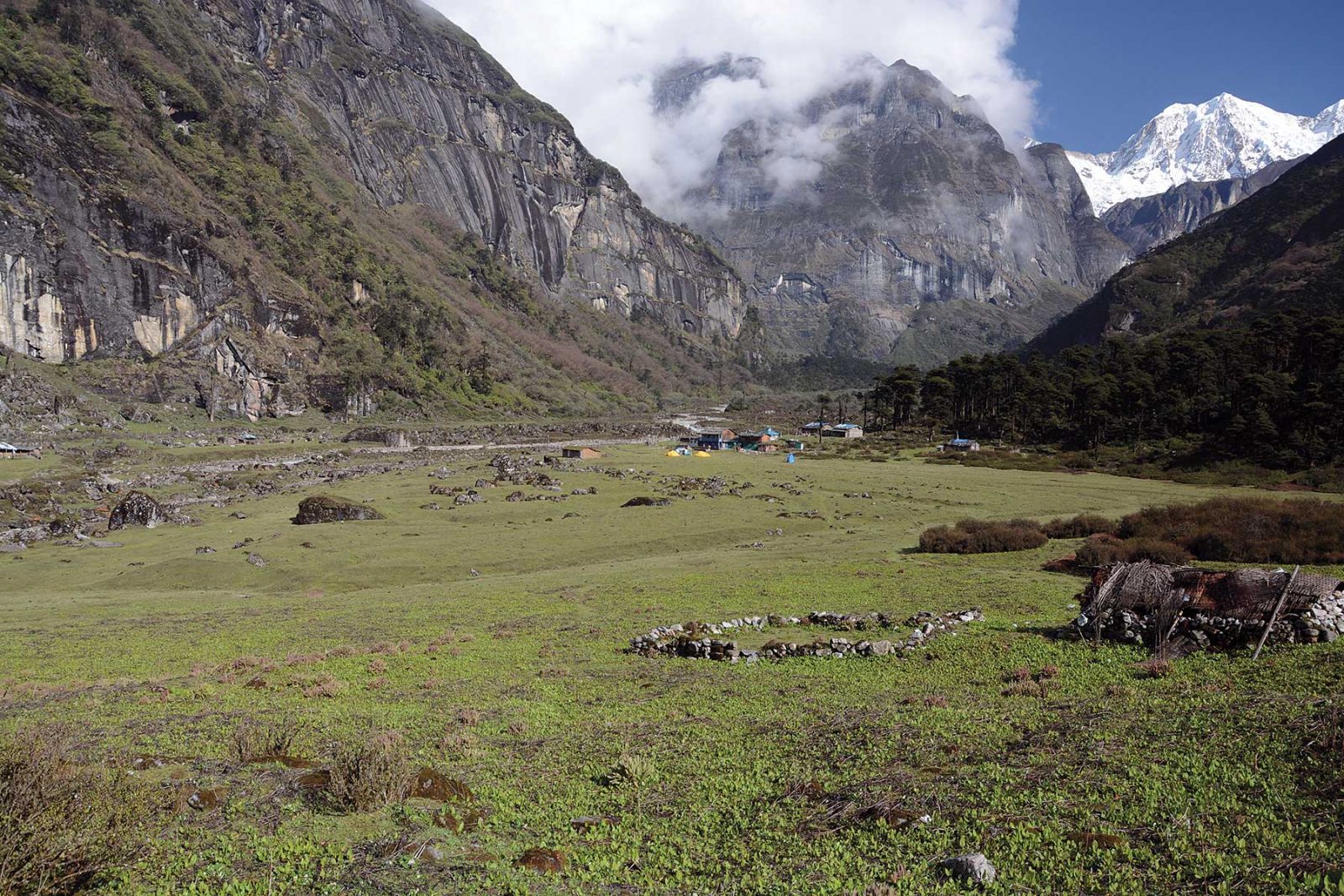
Figure 2. Flying up the Lower Barun Glacier from the Barun valley towards the West Col (left), then into the Hongu valley, and on over the AmphuLaptsa to the Khumbu (photograph by A. Byers).
.jpg) I first heard about the flood the day after it happened while in Dingboche village, Sagamartha (Mt. Everest) National Park and Buffer Zone. My colleagues Daene McKinney, Milan Shrestha, and I were working on a National Science Foundation research project entitled “Science-Driven, Community Based Approaches to Reducing Glacier Lake Outburst Flood Risks in the Nepal Himalaya.” Unlike most glacier research taking place today, which is focused entirely upon physical processes, our project was designed to better understand both the physical and human dimensions of glacial lake outburst floods in the Khumbu region. And since the majority of scientific GLOF and flood studies take place years to decades after the actual event, an immediate investigation of the upper Barun valley would offer a fresh and unprecedented opportunity to determine the flood’s exact source, causes, and consequences.
I first heard about the flood the day after it happened while in Dingboche village, Sagamartha (Mt. Everest) National Park and Buffer Zone. My colleagues Daene McKinney, Milan Shrestha, and I were working on a National Science Foundation research project entitled “Science-Driven, Community Based Approaches to Reducing Glacier Lake Outburst Flood Risks in the Nepal Himalaya.” Unlike most glacier research taking place today, which is focused entirely upon physical processes, our project was designed to better understand both the physical and human dimensions of glacial lake outburst floods in the Khumbu region. And since the majority of scientific GLOF and flood studies take place years to decades after the actual event, an immediate investigation of the upper Barun valley would offer a fresh and unprecedented opportunity to determine the flood’s exact source, causes, and consequences.
The Reconnaissance: And so on 2 May, 2017, scientist/businessman DJ Regmi , Daene McKinney, and I flew by helicopter from from Dingboche over the Amphu Laptsa (5,845 m) and West Col (6,143 m) passes and into the Barun valley (see: https://www.youtube.com/watch?v=R7660qs1d_4 ). All I had was a trekking map for navigation, but having crossed the Amphu Laptsa in 2009, trekked the length of the Hongu river in 2010, and visited the Barun valley multiple times on various research expeditions throughout the years, I was pretty sure that I could find the way—not 100 per cent sure, but close. Fortunately, Tim Field of Fishtail Air was our pilot , and between the two of us (after a detour or two) we found a route over the West Col, down the Lower Barun glacier, and on to the immediately recognizable Lower Barun glacial lake and Barun valley (Figure 2).
Once in the valley, the fact that both the Lower Barun and Dudh (Barun) glacial lakes were still intact ruled out the possibility of either being the source of the 20 April, 2017 flood. Flying down the Lower Barun glacial lake to the two lodges at Langmale, a stopover point on the way to the Makalu basecamp, the extent of the flood’s destructive path immediately became visible down the entire length of the Barun river as far as we could see. The flood path was easily traceable back up from the valley floor to a rather small glacial lake basin known as Langmale lake, due east and above the settlement area, that had obviously undergone a rapid and recent drainage (see: https://www.youtube.com/watch?v=kMOS7Yt45jY&feature=youtu.be).
From the fresh dust and debris on the glaciers above Langmale lake, we could see that some sort of avalanche from Saldim Peak (6,388 m) must have been the flood trigger. But that was about all that we could tell from such a quick and rapid flyover, and it was to be weeks before we were able to piece together the various events that had led to the flood in this beautiful, sacred, and remote valley of the eastern Himalayas.
Figure 3.YangleKharka in 2016 before the 2017 GLOF. The eyes and mouth of Shiva Danda can be seen in the background, a pilgrimage site involving a steep and exposed climb to reach the sacred caves that some 500 pilgrims attempt each year. The head and enlarged belly of AmaBuchun can be seen to the far right, where women have prayed for the gift of children for hundreds of years (photograph by A. Byers).
 The Barun Valley: The Barun valley has been known for centuries as a beyul (sacred valley) and pilgrimage site for both Buddhists and Hindus alike. It is home to a number of holy sites that include the massive rock face of Shiva Danda, where during the August full moon, pilgrims seek to bathe in the holy waters that Lord Shiva and Parbati played in(Figure 3); Ama Buchung, a massive stone mountain in the shape of a pregnant woman where women have come for centuries to pray for the gift of children; a huge waterfall emerging from a solid rock wall above the lodge at Riphuk Kharka, said to have been created by Guru Rinpoche in the 8th century in order to bring water from Tibet to the then-dry Barun valley; and Dudh Polhari at the base of Mt. Makalu (8,468 m), the source of the Barun’s sacred waters used by gods and goddesses, celebrated during the first part of each Magh (January/February) as “Maghe Sankranti” or the “Barun Mela.”
In contemporary times, the Barun has achieved some measure of fame as a yeti trapping and hunting ground, with at least five international expeditions launched in the region since the 1950s. It became widely known in the 1990s as a global biodiversity hotspot within the newly established (1992) Makalu-Barun National Park and Buffer Zone, and shortly afterwards as an adventure travel destination for remote area trekking and the climbing of Mt. Makalu (8,484 m), the world’s fifth highest mountain. Although there are no permanent villages, construction of lodges and tea houses began about 10 years ago following the end of the Maoist insurgency;the trek to Makalu basecamp can now be considered a “tea house trek” (although somewhat primitive when compared to conditions found in other popular trekking regions such as Khumbu, Langtang, or Annapurna). The valley’s seasonal residents are mostly Sherpa people from the villages of Navagaon and Tashigaon in the Kasuwa valley to the southeast, who migrated from the Solu Khumbu region in the northwest sometime in the 16th or 17th century. Blessed (or cursed?) with over 3 meters of rainfall per year and an extremely rugged and vertical topography, one can climb from the airstrip at Tumlingtar (285 meters) through six different vegetation zones while enroute to the Makalu basecamp (4,870 meters). They include the subtropical sal forests zone (200-1,000 meters), chestnut and alder forests (1,000-2,000 meters), the leech-infested magnolia/oak forests (2,000-3,000 meters), fir/birch/rhododendron forests of the subalpine zone (3,000-4,000 meters), the shrub/grasslands of the alpine (4,000-5,000 meters), and finally nival or perpetual snow and ice zone above 6,000 meters.
The first western visitors to the valley were the climbers Eric Shipton and Edmund Hillary, who caught a glimpse of the valley from a pass above the Hongu glacier in 1951. They returned in 1952 and 1954 to explore and climb in what they described as a “veritable paradise” of alpine pastures, forests, and waterfalls.
Economies today are based primarily on a combination of remittances, agriculture, livestock grazing (yaks, dzopkio, sheep, goats), the slow but steady growth in remote area adventure tourism, and annual harvesting of the “caterpillar fungus” yartsa gunbu and other medicinal and/or aromatic plants. Like so many other remote valleys in the Nepal Himalaya, the past 20 years have brought unprecedented physical, cultural, and economic changes to the region as a result of civil war, outmigration, shifting economies, and globalization.
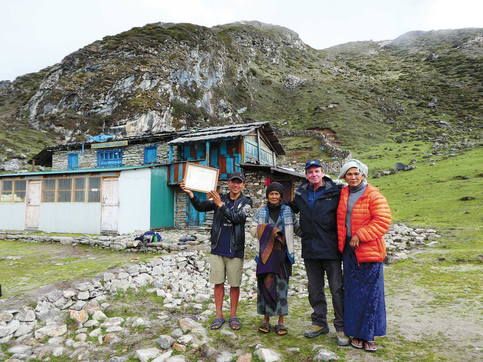
Figure 4.With Mrs. PasangWangchu Sherpa (second from left) in front of the Makalu Basecamp Yak Hotel and Lodge in Langmale in June, 2017. Her grandson is holding a framed "Makalu-Barun Conservation Project (MBCP) Certificate of Hotel Management Training" certificate that was awarded by our project to her husband, PasangWangchu Sherpa, in 1996 (photograph by M. Rai).
 All this to say that the Barun valley was not just an obscure watershed that happened to have experienced a GLOF, with only passing reference in the press: it was a real place with real people, a cultural and biodiversity treasure of global significance. Like much of Nepal, it has now entered a new era where glacier-related hazards—floods, icefalls, avalanches—can be expected to occur with a greater frequency and magnitude, with potentially serious consequences for downstream villages, agricultural land, and hydropower projects. Still, nobody in the valley was prepared for what happened on 20 April, 2017, especially since the source was such a tiny and insignificant glacial lake that had been completely ignored by scientists, international mountain research organizations, and the Government of Nepal alike.
The Return: Three weeks after our first helicopter reconnaissance, I returned to the Barun valley, again by helicopter, with porter and friend Bala Ram Rai and guide/research assistant Maoli Rai, both from Bung. Together, we spent the next three weeks trying to figure out the source, cause, and impacts of the Langmale outburst flood. This time I was able to guide the helicopter pilot over the high passes and down the Lower Barun glacier with ease, landing on a helipad near the Makalu Basecamp Yak Hotel and Lodge (Figure 4). This was the oldest lodge in the Barun valley, built in 1992 by Pasang Wangchu Sherpa whom I first met when I passed through the valley on a Makalu-Barun Conservation Project (MBCP) reconnaissance with Ang Rita Sherpa and Tashi Lama of The Mountain Institute (www.mountain.org). One of our tasks during the journey was to determine if the valley was pristine enough to qualify as a Strict Nature Preserve (SNR), a category within the then-new Makalu-Barun National Park reserved for the most undisturbed and untouched of wilderness areas. It spite of the Barun’s remoteness and phenomenal beauty, however, it did not qualify as a SNR, largely because of its history of hundreds of years of human and
cattle disturbance .
Unfortunately, once the helicopter had departed we found that the lodge was closed and locked, since we were now at the end of the tourist season and there was no reason for anybody to remain. This could have been a potentially serious problem, since we only had one tent and, I thought, enough food for several days.
“Well,” I said to Maoli, “it’s a good thing that we brought some food.”
“What food?” said Maoli. “I thought you said that you were bringing the food.”
So much for flawless planning. But after dividing a Snickers bar that I found in a forgotten corner of my pack into three portions, we sent Bala Ram down to the next lodge at Riphuk to see if he could find something to eat, about an hour’s walk down the valley. Meanwhile Maoli and I climbed up towards the glacier basins to the north to see if we could find a way to the Langmale glacial lake. We were immediately struck by the presence of a layer of fine, white dust that covered everything—shrub juniper, dwarf rhododendron shrubs, boulders, lodges, mani walls—as far as the eye could see. Since this had been absent the previous year when I’d visited the valley, I couldn’t help but wonder where the dust had come from, and why.
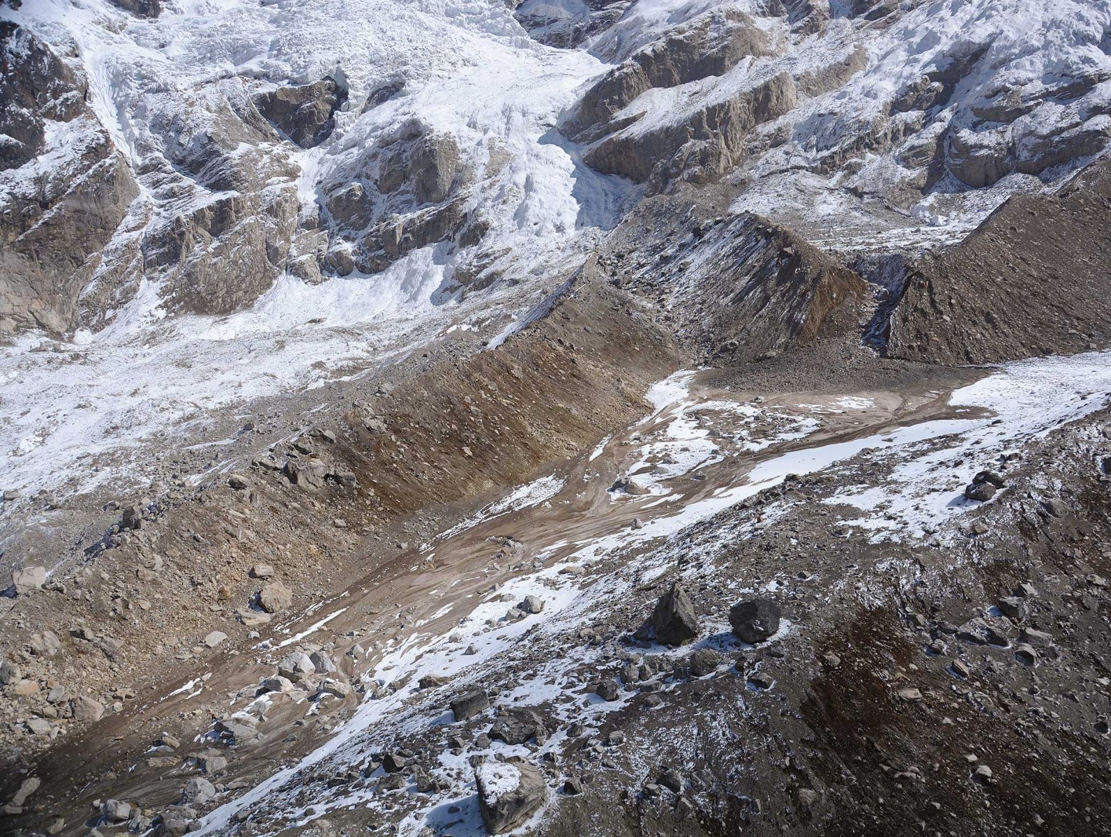
Prior to landing at Langmale village, the helicopter circled around the Langmale glacier basin so that we could get a better idea of how to reach the remains of the lake (Figure 6). This was easy in a helicopter, but now on the ground it took hours of climbing and rock scrambling just to reach a parallel basin to the west of the Langmale. We found that this lower basin was covered in a black, wet, silty mud, and that all vegetation was flattened and mud-covered, indicating that a flood had recently occurred here too. After several unsuccessful attempts to reach the lake—the flood had wiped out the original trail along the eastern terminal moraine--we found a recent, steep breach in the right lateral moraine that separated the two basins that we were able to climb up and into, reaching the
lake region.
Figure 5.Langmale glacial lake basin (center) as seen from our helicopter. The breach in the terminal moraine (upper right) provided the outlet for the flood waters. The force of the flood was so great that parts of the glacier basins to the left and right were also submerged in a thick slurry of water and sediment from the lake bed (photograph by A. Byers).
 Once on top we realized that this was actually a torrent, or erosive channel that the main Langmale flood had carved when it had jumped over the lateral moraine and into the basin below us, explaining the cover of mud and flattened vegetation there. Climbing up and down a fresh and unstable torrent was perhaps not the safest nor smartest thing to do, especially with its overhanging boulders at the top, but it was the only way to get up closer to the Langmale glacial lake. In fact, Bala Ram, the smart one in our group, refused to return to the lake after his first trip, citing his youth, good looks, and eligibility for marriage as simply not being worth the risk. As none of these attributes applied to either me or Maoli, he and I were to make a half dozen trips up and back to the lake during the course of the field investigation., sadly without Bala Ram.
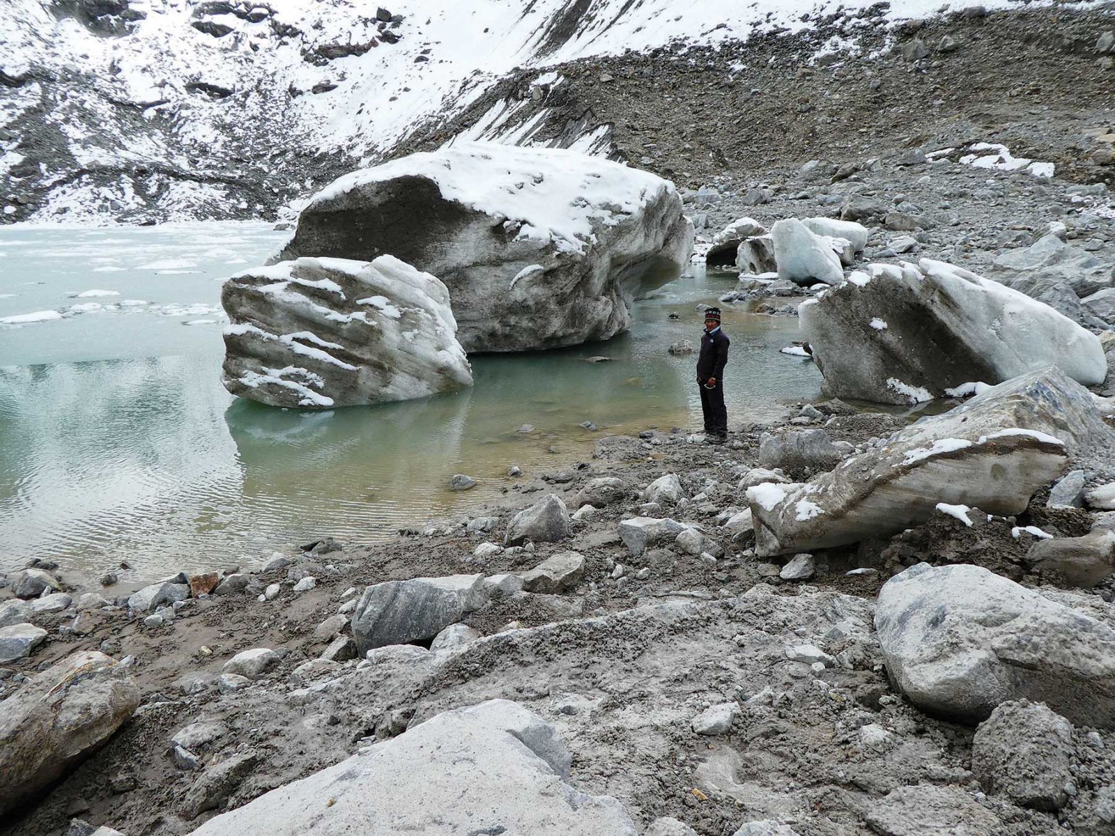
Once in the Langmale basin, we were struck again by the power and magnitude of the flood, which had uprooted and flattened every alpine shrub for a dozen square kilometers around us while covering everything—moraines, hills, outwash plains—with a black silty mud. Continuing up the flood channel to the breached terminal moraine, we climbed up and into the glacial lake basin which looked as though it had recently been the victim of a major catastrophic event, which it most certainly had. Blocks of ice the size of houses lay on the now largely drained lake basin floor (Figure 6), and ice blocks over 1 meter in diameter had somehow been hurled a good two kilometers beyond the breached terminal moraine to the outwash plains below. Rock boulders 3 meters and more in diameter also littered the basin floor, and by their sharp and angular nature it was clear that they were new and fresh.
We returned to the Langmale lodge to find six young boys on their way to the Makalu basecamp to help close out the season, as international climbing expeditions have become a major source of supplementary income for local people each spring and fall. Tashi Sherpa of the Makalu Basecamp Yak Hotel and Lodge in Langmale had also returned from the basecamp to open his lodge, after hearing our helicopter earlier that day.
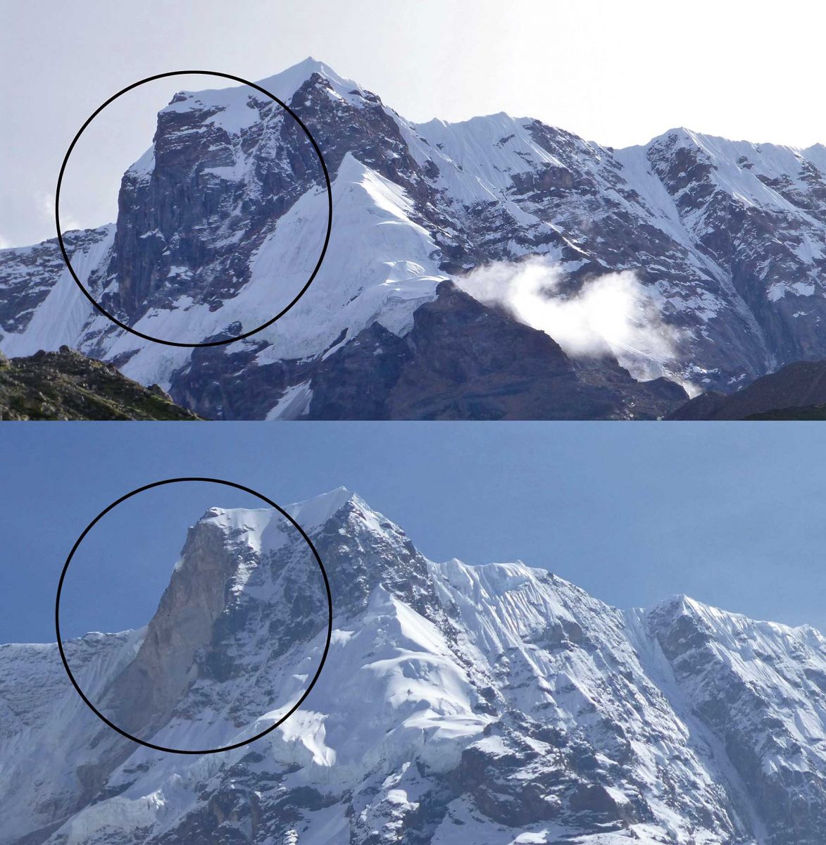
Following our queries about the possible cause of flood, he casually pointed out a massive slab of solid rock that had broken off from the southwest face of Saldim Peak (6,388 m) the day of the outburst flood, a failure that was possibly linked to the destabilizing effects of the 27 April, 2015 earthquake and aftershock (Figure 7). Millions of cubic meters of rock must have plummeted down to the Langmale glacier and glacial lake below, triggering the outburst flood that had caused the massive devastation and destruction of the valley that we had observed the month before by helicopter.
Figure 6. Huge blocks of ice and rock covered the Langmale lakebed when we arrived on 2 May, 2018, with smaller blocks hurled within a further 2 kilometers down the valley (photograph by A. Byers).
 Putting It All Together: During the next week we moved up and down the flood channel from the source near Langmale to the flood’s attenuation zone (i.e., where the flood water spread out and lost energy) at Yangle Kharka. More evidence of the stunning power of the flood was revealed, such as the deposition of unusually massive boulders near Nhe Kharka that had eroded out of a steep section of the river channel (Figure 8); the scouring to bedrock of the riparian zone of the Barun river from the Langmale glacier all the way to the confluence with the Arun (Figure 9); and large boulders deposited and lodged in trees, with the lower sections of the trees stripped of bark by the abrasion forces of the flood (Figure 10). By combining our field measurements with dozens of interviews with local people, later supplemented by the results of remote sensing and flood modeling analyses, we were able to piece together the complex series of events that most likely led to the Barun GLOF.
As it turns out, the rockfall from Saldim Peak on 20 April, 2018 was not actually witnessed by anyone, partly because of the heavy fog that covered Saldim Peak that day, and also because most of the valley’s seasonal residents were up at the Makalu basecamp closing down the season. However, all associated sounds (i.e., from the avalanche, wind, floodwater, etc.) were heard and/or felt by numerous informants, and the fresh scar left behind on the rock wall was clearly visible from the village (Figure 7).
According to a climbing guide who was camped above Langmale glacial lake the day of the flood, the first slope failure occurred around 12:30 p.m. and was relatively small, causing only a minor rise in Barun River’s water level when it reached Yangle Kharka. This event was largely ignored by villagers and tourist groups alike. The second slope failure at 1:30 p.m., however, consisted of a very large volume of rock that fell approximately 570 m down to the unnamed glacier above Langmale glacial lake. The impact precipitated an avalanche, carrying blocks of rock and ice up to 5 m in diameter down another 630 m into Langmale glacial lake, triggering the GLOF. The rockfall and avalanche also created hurricane-force winds and a huge dust and debris cloud of whitish sand-rich deposits that settled over shrubs, boulders, lodges, mani walls, and all other surfaces, in a fan-like pattern from the impact zone to about 4 km south of Langmale glacial lake—the “white dust” we noticed the day we began our investigation of the flood at Langmale. The rockfall also left behind a large debris fan on top of the glacier, later clearly visible on the satellite imagery that we obtained, which traced the rockfall’s trajectory as it descended from its source on Saldim Peak to the
lake below.
The mass movement that entered Langmale glacial lake caused a tsunami-like wave, between 25 m and 30 m in height, that overtopped its terminal and westernmost lateral moraine in the form of a hyper-concentrated slurry of silty sediment, thereby allowing flood water to enter adjacent glacier basins. The floodwater continued on to cascade down a 200 m rock wall into the Langmale river channel below, where the combined torrents entrained more material and debris before merging with the Lower Barun glacial lake outlet stream below the settlement of Riphuk. Boulders, sediment, and uprooted trees were strewn along the length and width of the flood channel from below the settlement of Langmale to Yangle Kharka, with displacement of particularly large boulders (>10 m in diameter) occurring 0.5 km downstream from a steep section of the Barun river to the vicinity of Nhe Kharka. As mentioned, massive new canyons and floodplains were created that destroyed dozens of hectares of pasture and forest land.
Figure 7.Saldim Peak in 2014 (top) and 2017 (bottom); the circles show the area of the slope failure (photographs by E. Byers (top) and A. Byers (bottom).
 Eyewitnesses of the flood at Yangle Kharka reported hearing a very loud noise sometime in the early afternoon, described variously as “like an avalanche,” “loud roar,” or “helicopter,” followed by a huge cloud of dust. The dust cloud was accompanied by high winds at least as far as Riphuk, as villagers reported that trees there had been blown down by hurricane force winds. At Yangle Kharka, a large flood of water, sediment, and trees then descended the river at around 2:30 p.m. Although considerable differences exist between informant accounts for the actual times of the two rock avalanches, arrival of the flood at Yangle Kharka, and other phenomena, those reported here are considered to be reasonably accurate based upon the flood’s arrival at Barun Bazaar at 4:00 p.m.
Fortunately, no one was killed or injured by the event, and the tourist lodges at Langmale, Zak Kharka, Rephuk Kharka, and Tematang escaped major damage. Yangle Kharka, however, suffered the loss of three buildings and dozens of hectares of valuable grazing land. Buildings destroyed included the Makalu-Barun Hotel, dramatically captured in a video filmed by a visiting German climbing team as it floated away (see: https://www.youtube.com/watch?v=2VB1PRgb_Ic); an old gompa built in the early 1990s (curiously, the new one built nearby in 2014 remained unscathed), and two tea shops. In addition, at least 24 dzo (yak-cattle crossbreeds) were killed, and six bridges were washed away. The local people that we interviewed in Yangle Kharka were deeply concerned that the coming tourist, pilgrimage, and yartsa gunbu seasons would be negatively impacted because of the damaged or destroyed trails, bridges, and dramatically altered landscapes.
The eyewitness video showed that the color of the debris-laden flood water was dark gray-brown, in contrast to the milky blue-pale tan color from suspended silt that I observed during the 2014 monsoon season at the same location. No reports of unusual smells were given, such as the “earthy” odor reported for the Dig Tsho GLOF in 1985, or “gunpowder” smell reported for the Tam Pokhari GLOF in 1998.
The Future: The series of events that led to the Langmale GLOF was similar, in many ways, to the Seti Kosi flood north of Pokhara that killed over 70 people on May 5, 2012. In the case of the Seti Kosi flood, the trigger was a massive rockfall from Annapurna IV that plummeted into a recently landslide-dammed lake, triggering the flood that was also accompanied by massive dust clouds, hurricane-force winds, and hundreds of hectares of wind-flattened forests.
Prophetically, Dr. Jeff Kargel of the University of Arizona, who spent two years studying the Seti Kosi flood with Dr. Dhananjay Regmi, said in 2014 that “…there are good reasons to be concerned [that] something like this will happen again. It’s inevitable.” Just three years later, the inevitable came true as a result of a massive and totally unanticipated rockfall into a small glacial lake in the Barun valley, so small that no one ever suspected it of being dangerous.
Figure 8. Massive boulders deposited in the Barun river channel near NheKharka. Note the people in the foreground for scale (photograph by C. Carpenter).
.jpg) Recent studies suggest that an increase in GLOF and other glacier hazard frequencies in Nepal can be expected during the next decade and well into the 22nd century. Continued integrated, interdisciplinary research will be important to achieving the fullest understanding of the conditions under which these GLOFs may be triggered, as well as to the development of effective risk reduction strategies (e.g., lake lowering, early warning systems, regular monitoring). The Langmale GLOF experience recounted here also demonstrates the need to conduct field-based GLOF analyses as soon as possible after the event, otherwise valuable evidence may be lost and the complexity of the event misunderstood or misinterpreted.
Recent studies suggest that an increase in GLOF and other glacier hazard frequencies in Nepal can be expected during the next decade and well into the 22nd century. Continued integrated, interdisciplinary research will be important to achieving the fullest understanding of the conditions under which these GLOFs may be triggered, as well as to the development of effective risk reduction strategies (e.g., lake lowering, early warning systems, regular monitoring). The Langmale GLOF experience recounted here also demonstrates the need to conduct field-based GLOF analyses as soon as possible after the event, otherwise valuable evidence may be lost and the complexity of the event misunderstood or misinterpreted.
New adaptive measures among mountain people will be required in order to minimize the damage and loss of life that these floods may result in. They include such common sense strategies as locating new infrastructure beyond what are clearly recent or historical floodplains (or risk watching your hotel float away, as at Yangle Kharka), and building well away from fresh torrents and other indicators of recent hydrologic/geomorphic activity. Although it has yet to make the popular press, many mountain communities in Nepal are already developing, and quietly implementing, their own adaptive mechanisms to climate change, such as the building of hundreds of gabions that can divert flood water from villages and by constructing higher bridges that are beyond the reach of all but the highest of flood waters.
Likewise, major infrastructure initiatives, such as large hydropower projects, will also need to recognize and plan for future GLOF events or risk the loss of their multi-billion dollar investments, as well as their goal of providing electricity to millions of people throughout Nepal. For example, a 2014 report by the U.S. Agency for International Development (USAID) concluded that few, if any, major hydropower projects in Nepal have included GLOFs in their feasibility studies and donor reports. Visiting the site recently of the Arun III’s so-called “run of the river” hydropower project below Num, I found myself imagining what the forthcoming 70 meter-tall, 466 meter-long concrete gravity dam, with a storage capacity of 14 million cubic meters of water (read: really big lake), would look like once it was completed. Likewise, I couldn’t help but wonder how long the structure would survive before a major GLOF from the Lower Barun, or from a smaller and obscure glacial lake such as Langmale, or just over the border in Tibet, would come barreling down the Arun, destroying everything in its path, 70 meter-high dams included. As Kargel suggests and my old mountain geographer instincts scream, it’s just a matter of time.
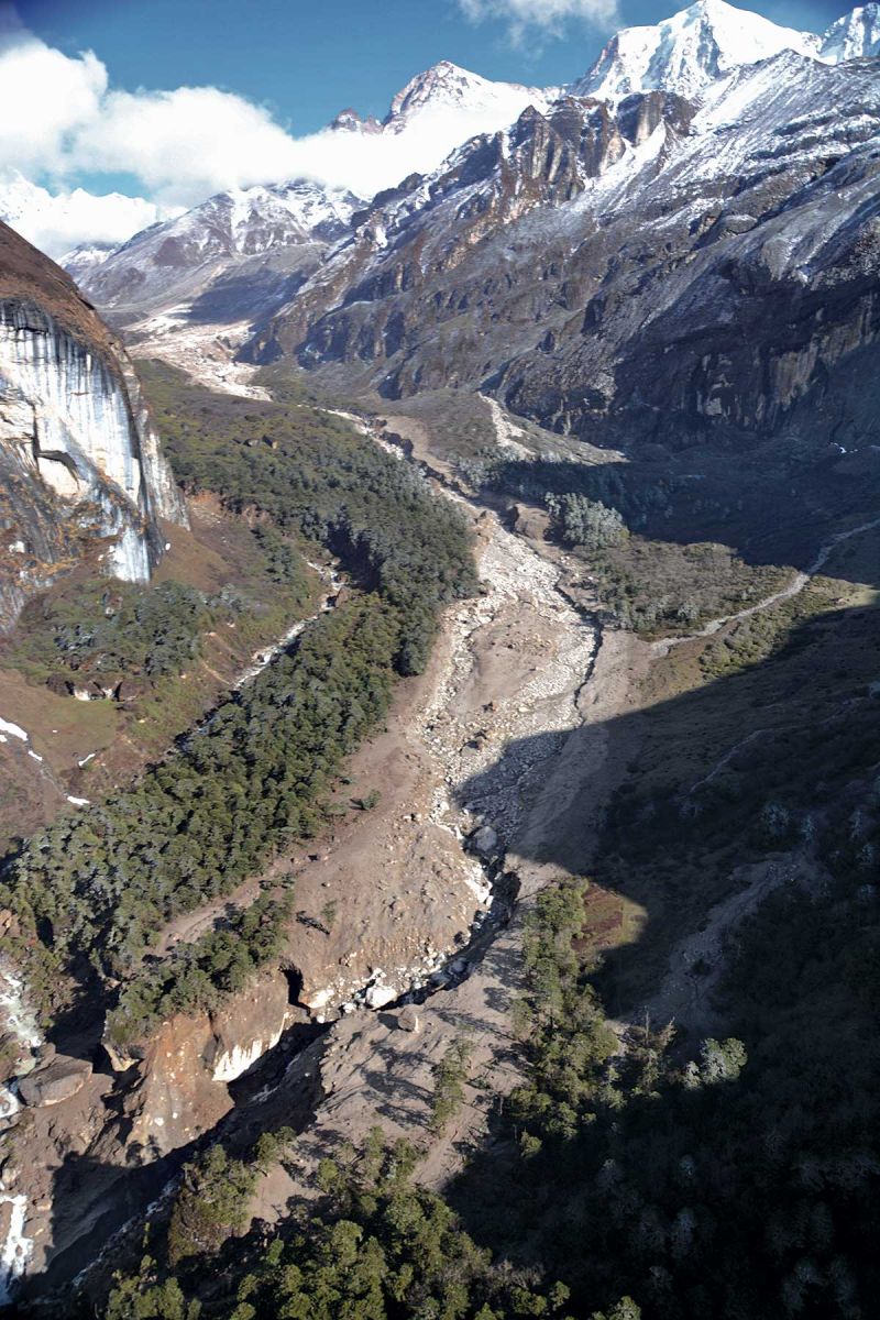
Figure 9.Flood path as seen from the helicopter, looking upstream toward the source (photograph by A. Byers).
 On the local level, risk awareness, disaster management, and early warning system training will be of critical importance to the lives and livelihoods of people living in villages and cities located downstream of high mountain glaciated landscapes. The fact that so much flood water originated from such a small and apparently harmless glacial lake such as Langmale also suggests a need to rethink our thresholds for potentially dangerous lakes, which are clearly not limited to massive bodies of water such as Tso Rolpa, Imja, or Thulagi glacial lakes.
Based upon observations of older GLOF scars in other climatically similar regions of Nepal, it will take about 15 years for the scoured river banks of the Barun’s riparian zone to re-establish pioneer vegetation such as mosses, which in turn will allow for the establishment of fir, birch, rhododendron, and other seedlings. In fact, in 2014 and 2016 we noted the presence of even-aged (40 year old) stands of fir trees within the Barun’s lower river channel, indicating that GLOFs occur on a regular basis within the valley, and that they are not just a recent, one-time or freak event.
In October 2018, it was clear that trekking tourism in the Barun had not been adversely impacted by the flood, as local bridges were rebuilt within weeks after the flood event occurred. The trail to Makalu basecamp has undergone major improvements, and is in the best shape it’s ever been in. Lodges have been rebuilt to accommodate the growing numbers of tourists. Likewise, mountaineering expeditions showed no signs of slowing down, as most groups continue to helicopter in and out of the Makalu basecamp, leaving the trekking or climbing company to figure out the food and basecamp logistics. Yartsa gunbu collection has also continued without interruption, as the major harvesting sites are on high alpine ridges well out of the flood path. Clearly, the people of the Barun valley are particularly resourceful and resilient, having lived and worked in this extremely remote corner of the Nepal Himalaya for centuries. What could have devastated other regions for decades was dealt with quickly, efficiently, and with little outside
financial support .
At the same time, however, an enhanced and palpable fear of future GLOFs is now firmly embedded in people’s minds. Will the massive Lower Barun lake burst someday, dwarfing the impacts and devastation of the Langmale GLOF? Or another small and obscure glacial lake, such as Langmale, flood because of reasons totally unanticipated nor expected?
Unfortunately, only the valley’s geology, climate change, and gods and goddesses know for sure. But if local people and governments continue to develop ways to minimize the damage, such as by strategically locating infrastructure out of harm’s way, then everything will be just fine.
Figure 10. Boulders lodged in trees in the vicinity of YangleKharka. The fir trees (Abiesspectabilis) were also stripped of their bark by the sediment-laden floodwaters (photograph by A. Byers)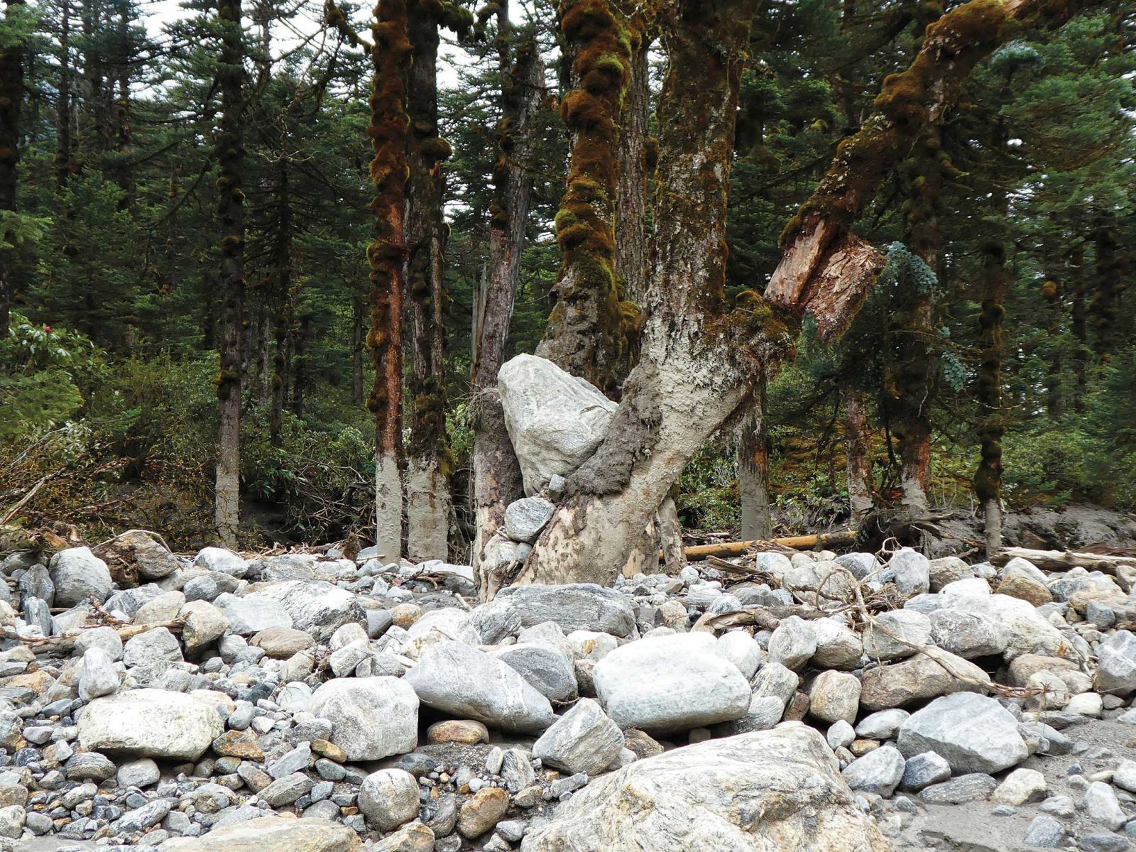
Notes:
1. The Nepali press reported that the lake was approximately 3 kilometers long, 500 meters wide, and that it drained 24 hours after the initial flood event. In fact, based on interviews with local people in Barun Bazaar in October, 2018 and our own field investigations, the debris-dammed lake was at most 200 m in length, and drained spontaneously within one hour of its formation. The flood nevertheless caused considerable damage as described in the text.
2. The results of our detailed scientific investigation of the flood can be seen in Byers et al. (forthcoming), “A rockfall-induced glacial lake outburst flood, upper Barun valley, Nepal,” Landslides. https://link.springer.com/article/10.1007/s10346-018-1079-9
3. Director, Himalayan Research Expeditions (http://www.himalayanresearch.com.np/), which with the Nepal Army successfully lowered Imja glacial lake by 3 m in 2016, the highest glacial lake lowering project in the world to date.
4. Tim was to get us out of trouble a year later when our expedition couldn’t find a trail from the Kal Pokhari Danda down to the Hongu valley. See: Byers, A.C., “A Walk Across Makalu-Barun,” ECS/Nepal, July 2018.
5. Chains and pitons were recently installed by the national park in some places to assist pilgrims with this difficult climb.
6. The highly valuable “caterpillar fungus” attracts approximately 3,000 harvesters each May-mid-July harvesting season to the alpine slopes of the upper Barun valley. As opposed to other harvesting sites in Nepal and Tibet that have experienced adverse environmental and social impacts, our 2016 study showed that local people and national park authorities have developed a remarkably stable and low impact system of yartsa gunbu harvesting in the Barun. See: Byers et al. (forthcoming), “Impacts of Yartsa Gunbu Harvesting on Alpine Ecosystems in the Barun Valley, Makalu-Barun National Park, Nepal,” Himalaya: Journal of the Association for Nepal and Himalayan Studies.
7. See: Byers, A. “A Walk Across Makalu-Barun,” ECS Nepal, July 2018, for a detailed history of the Makalu-Barun National Park and Buffer Zone.
8. See: Byers, A.C. 1996. Historical and contemporary human disturbance in the upper Barun valley, Makalu-Barun National Park and Conservation Area, east Nepal. Mountain Research and Development 16(3): 235-247.
9. The Department of National Parks and Wildlife Conservation (DNPWC), Nepal Mountaineering Association (NMA), and various private donors made generous contributions toward the rebuilding of local bridges and trails throughout the upper Barun valley.