When you arrive for the first time in a remote, ancient town like Kagbeni, what do you say about it? What do you write?
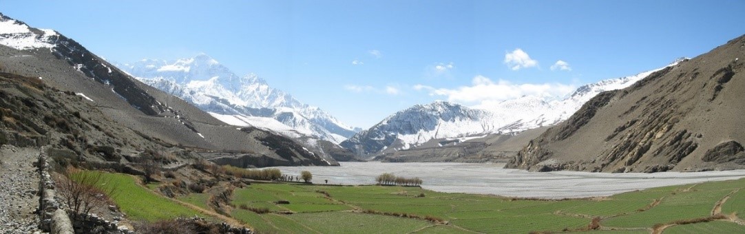
For the Tibetologist David Snellgrove, it was the physical features ? the houses, the monastery, and the strategic location that gave it a uniquely dominant identity. Kagbeni (9,200 ft./2804 m.) sits alongside the Kali Gandaki river north of the Dhaulagiri and Annapurna massifs in Mustang District, well within Nepal’s Tibetan culture area. Snellgrove wrote about it in ‘Himalayan Pilgrimage’ (1961), a book describing a long research expedition along the border. He wrote –
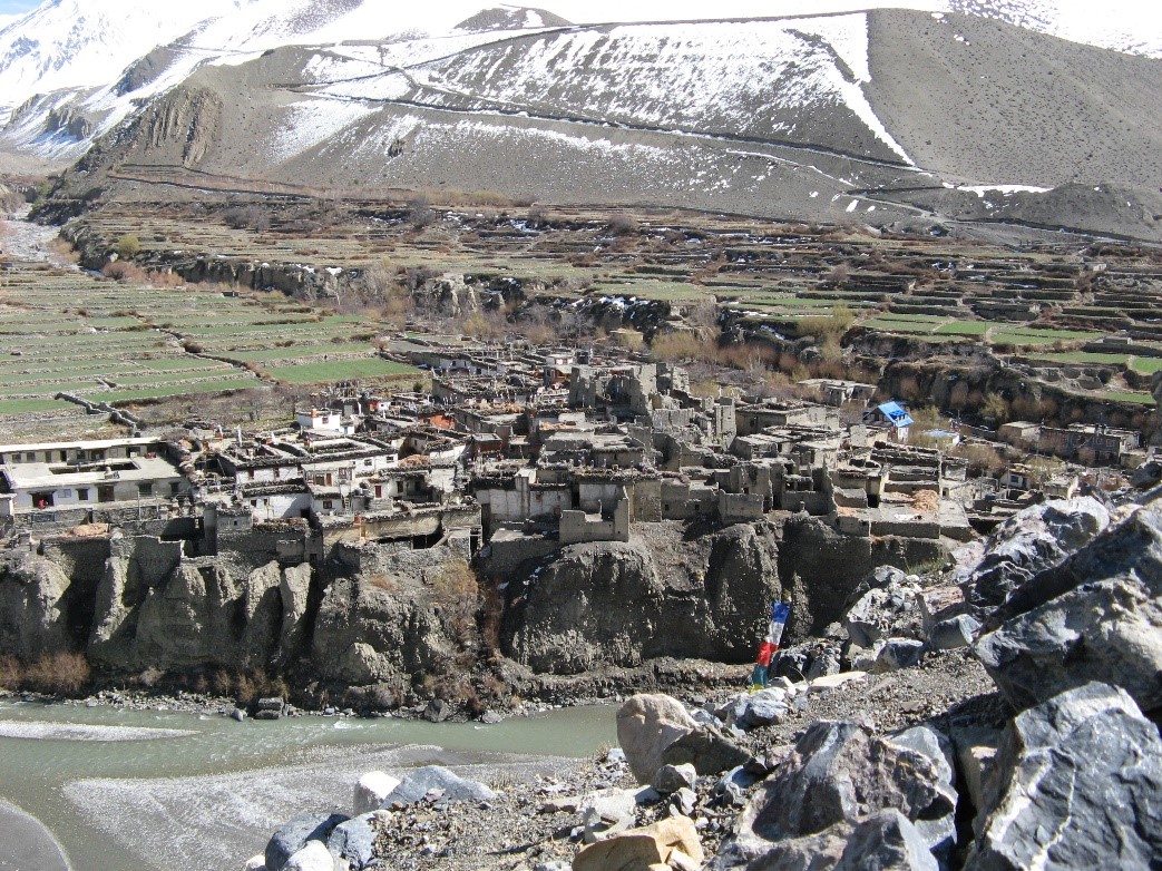
“Kagbeni with its fifty or so houses is perhaps best described as a citadel. It is built on the river’s edge and effectively blocks the valley. The local Tibetan name is in fact just Kak (bKag) which is a word meaning ‘block’. There was once a king but his palace is falling down and his dethroned descendants are too poor to repair it.”
“The blue sky, tumble-down buildings, whitewashed walls, happy children playing in the courtyards, little load-laden donkeys, women weaving in the shade, the rocks and bare brown earth beyond and the great snow-peaks surmounting the scene. The houses stand close together, but since each is built around a courtyard, there was far more space and light than we were accustomed to.
The monastery, he noted, was “a fort-like structure that has suffered from the effects of war. Only the main temple remains amidst ruined walls.”
Four ancient trade routes cross at Kagbeni ? north from Lo Manthang; east from Manang across Thorung Pass; west from Dolpo; and south from the Thak valley and Nepal’s midhills. Snellgrove speculated that one of the “main sources of wealth must have been the dues levied on the grain coming up from the south and the sale and wool going down from the north.”
??????????????????????
When I first visited Kagbeni in 1964, eight years after Snellgrove, my interests were in the people and their way of life. As we entered, Bruce (my trekking companion) and I met a trader named Ang-gyel who invited us to his house. (It is now the Red House lodge, popular with foreign trekkers.) There we met several Khambas, Tibetan guerillas engaged in a clandestine war against the occupation of their homeland. I wrote about one of them, a tall fellow, in my journal:
“He spoke no Nepali, and the only thing I could understood was Tibetan for ‘drink tea’, which he served to us in little wooden bowls with a smile of genuine friendliness. And when he and his Khamba friends sat down to eat bowls of steaming thukpa (noodle soup), he made sure that we also got some from the pot.
“The Khambas were interested in our ice-axes and our olive-green Kelty backpacks. They tried them on for size and paraded around the room like mountain men, making murderous gestures with the pointed ice-axes (against some imagined enemy).
Before supper Bruce and I toured the town, through its covered alleyways and medieval courtyards, past fields and threshing yards where farmers were flailing freshly harvested buckwheat.
From Kagbeni we trekked up the Jhong River valley next day to Muktinath shrine (12,172ft./3710m.), where Hindu pilgrims seek salvation (mukti) from Lord Vishnu. After one night there, we ascended the torturously steep switch-backs to Thorung Pass (17,769ft./5416m.). Along the way, our Khamba friends passed us on horseback. They looked well-armed, no doubt going to meet other colleagues-in-arms in Manang, across the pass. We arrived late at the top and spent the night out in the cold.
In Manang valley, the villagers treated us like curiosities. The only other foreigners they had seen here were a few unwelcome European mountaineers a few years earlier.
Those were troubled times in the border districts, so we moved along quickly. When we reached our Peace Corps village in the midhill district of Lamjung, five long days from Kagbeni, our holiday was over.