The vehicle swept smoothly along the winding mountain road. The muted hum of the engine reassured me. The power, grace and attention to detail expended while crafting the vehicle filled me with admiration. I was in a new tall boy Toyota Hiace which has revolutionized transport in Nepal. Fast and comfortable, it has cut down travel times significantly. The Jiri Hiace micro I was in shaved more than three hours off the long journey.
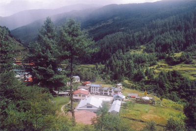
A panoramic view of the village of Junbesi
We stopped at Lamosangu (‘Long Bridge’) for lunch. The road there was lined by shacks serving lunch, their specialty being the Nepalese staple of dal-bhaat-tarkari (lentils-rice-vegetables) with chicken or mutton curry. I was impressed by the efficiency of these establishments.
We drove on. It was a quarter past three when we reached Jiri. The name Jiri is said to be derived from Jirel (an ethnic group that lives in this region). I met my first Jirel, Mr. K.B. Jirel, the manager of the Cherdung Lodge soon after reaching Jiri. He came to see me (knowing I was an MD) with complaints of pain in his chest and acid peptic disease. He was concerned about his health after a fall from a trail while leading a trek about two years back.
I had read a lot about Jiri, one of the first recipients of Swiss aid in Nepal. The town was small and compact in the curve of a forested hillside. I am basically a small town guy and feel happiest in the warm cocoon of relationships which small towns nurture. I stayed at the Cherdung Lodge, and after dusk the lodge lights added a magical atmosphere to the cool evening. People were promenading along the road and shops were doing brisk evening business.
The first day’s hike to Deorali
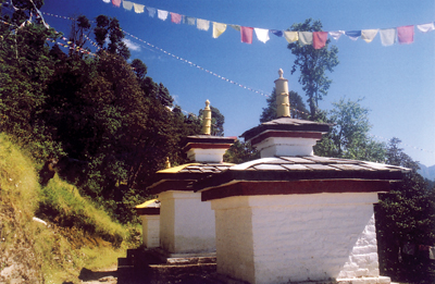
Chortens by the trailside
It had rained heavily the day we arrived, so the next morning was cloudy. I was conscious of the long distance to be traveled and decided to start early, at 6:30 am. The Lonely Planet guide mentions Bhandar, a Sherpa village, as the first day’s destination, but qualifies that with the observation that it will likely be a long and hard day and you may have to settle for Shivalaya or Deorali if you are not in excellent physical condition.
Out of Jiri the trail climbed a hill, on a trail of red, slippery soil. There’s a saying in Nepali―raato maato, chipaalo baato (‘red soil, slippery trail’). True! But, I managed to stay on my feet as the path ascended to the village of Mali on the direct, high route to Shivalaya (1800 m), bypassing the Newar bazaar of Those. There are supposed to be good mountain views on this trail, but that day the Himals were veiled in cloud. (I had better luck on the return journey when it was clearer.)
From the ridge top it was a long descent to the village of Shivalaya. The fair weather car road to Shivalaya frequently intersected the trail making route finding difficult. Shivalaya means ‘the abode of Shiva’, and was a long, straggling bazaar town. It was after twelve o’clock, so I stopped for lunch at the ‘Shivalaya Hilton’. One member of the lodge owner’s family was a certified medical assistant (CMA) who also ran a small medical shop nearby.
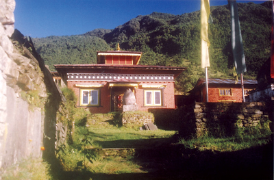
A monastery at the trailside
Now, the trail climbed steeply again to the settlement of Sangbadanda. But the trail was in such poor condition that the soft soil had been washed away by the heavy monsoon. I met two young European gentlemen, a German and a Czech, who were walking to Lukla and beyond, and our paths often crossed throughout the trek. Most trekkers were wearing T-shirts with a fleece pullover and cargo pants. Repeated admonitions in trekking guides about being properly dressed and against wearing shorts (especially for women) and semi nudity seemed to have worked. Trekkers were also both culturally and environmentally conscious treating Nepalis with respect and not dropping trash on the trail. The locals, however, threw their used packets of noodles, biscuits, chocolate wrappers and tobacco on the trail. There were golden yellow packets of ‘Golden Like’ brand guthka (chewing tobacco) litter everywhere. When I was confused about which trail to take I looked around for this trash. The trail with the maximum amount of trash was most probably the right one! Environmental awareness programs for locals are desperately needed.
The Czech fellow was tall and well built. Many of the tallest men I have met on treks are from the Czech Republic. I’ve read somewhere a claim that the Dutch are among the tallest people in Europe, but the Czechs can give them a good run for that prize.
The climb was long and tough, as the walk east to Lukla cuts across river valleys and high ridges against the grain of the land. You have to climb all the way to the top of tall hills and then descend completely to the river below before repeating the process. It has been calculated that you more than ascend and descend the altitude of Everest (8848 m) before reaching Lukla. Why Lukla? It’s where Hillary built the main airport that services the Everest region, and from there north one is on the trail past Namche and Tengboche to Everest Base Camp.
On my first day’s trek, it was after 4 pm when I finally arrived at Deorali (2700 m), a collection of lodges on a pass. I stayed at the Lama Lodge for the night. With the reduction of trekker traffic and the walk from Jiri being done mainly by porters carrying loads, many good lodges are slowly downgrading. Porters were either in flip flops or in canvas shoes carrying tremendous loads in their bamboo baskets using a tumpline (naamlo) across their forehead. Most were carrying duffel bags packed with the ‘extra’ gear of trekkers who were flying to Lukla. Some were carrying containers of kerosene, or tables and chairs, and other camping equipment. I was impressed by the feats of these ‘Supermen of the Himalayas’, but also saddened in some cases by their plight. One reason is that trekkers can fly past this route, either directly to Lukla, or to Phaplu in the hills.
The fried rice at Lama Lodge that evening was prepared with a twist. The sauce gave it a piquant tanginess and the vegetables were dipped in spices and fried.
On to Sete
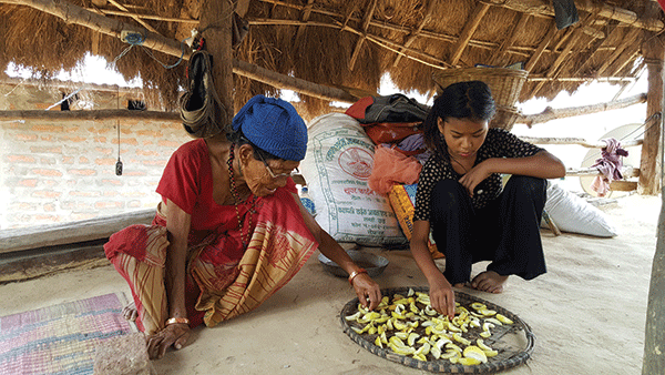
From Deorali, the trail dropped steeply downhills and I soon found myself on the wrong track. I had to climb down along a goat trail to the Sherpa village of Bhandar (also called Chyangma), from which it was a long walk along narrow paths to Kenja. After walking along the Kenja Khola (stream), I arrived in Kenja and ate my lunch at a hotel in the bazaar. The lodge was attractive, the food good, and both on my onward and return journey I was tempted to stay at Kenja. Kenja, at around 1600 meters, is a big village and when I passed through I saw that the weekly market, the Sunday bazaar, was on. Stan Armington in his book Trekking in the Nepal Himalaya states that in 1969, when he first passed through Kenja, there was a single dingy shop. Today there are a number of guest houses and shops including the ‘Sherpa Guest House’ advertising rooms and hot showers at the ‘princely’ rate of ten rupees. The specialty of the Sunday Bazaar is instant tailoring on hand-operated sewing machines. Large numbers of people were getting their clothing stitched.
I was worried by the rapid growth of population. Most families had at least three to four children. What will they do when they grow up? Nepal has been spared the devastating effects of rural poverty because most families own at least ‘some’ land. In the future this may not be true. I am convinced that all developing countries should take urgent and concrete steps to check the growth of their exploding populations. The future of our planet depends on it.
From Kenja it was a long ascent along the Lamjura Bhanjyang to the 3500 m Lamjura La (pass). The initial climb was very steep and I gained altitude rapidly. My night stop was Sete, a small village at around 2500 m, but as the climb was a bit rough, it was 4 pm in a light drizzle when I arrived at where I thought it should be. But, Sete was nowhere in sight. I was resigned to keep going. After a very steep ascent along a ravine, I saw the village high up on the next ridge. I was disheartened. Why is it that one’s daily destination always seems to be on top of a hill? It took a massive effort of will to continue following along behind a group of kuires (foreigners) and their guide. I stayed that night at the ‘Sherpa Guide Lodge’, where the lodge owner was very solicitous and concentrated on making his guests feel at home. After talking to me, he expressed a particular interest in the process of medical education in Nepal, as he wanted his daughter to take up medicine.
The conversation was good and the food at his lodge was tasty and the place homely, so I stayed with him again two days later on my way back from Junbesi.
Across the Lamjura La to Junbesi
From Sete the trail continues climbing to the Lamjura pass, passing through moist deciduous forests of rhododendrons, magnolia, maple and birch. The mountainside is said to be a riot of colors in early spring when the rhododendrons, Nepal’s national flower, are in bloom. I heard various animal sounds and bird calls deep in the forest. Colorful butterflies and moths were plentiful, flitting from plant to plant on both sides of the trail. Villagers were grazing livestock deep in the forest and their shrill piping whistles broke the silence. A Sherpa family was on its way to Junbesi. I talked with the matriarch and she assured me that I will be in Junbesi in about three to four hours. The group consisted of ladies of varying ages; a young boy of around 14 was the only male. The two older ladies were dressed in the traditional brown Tibetan chuba (gown) with colorful sashes while the young ladies were in jeans, pullover and T-shirt.
Jiri to Junbesi trek
Number of days: 5 to 6 (return)
Road head: Jiri. Buses also go to Shivalaya and occasional ones to Bhandar. The Jiri micro is a good way to reach Jiri.
Lodges: Good
Difficulty: Moderate
Highlights: A west to east trek which cuts across high ridges and river valleys. The cheese factory at Thodung (and also at Jiri), monasteries and distant mountain views. Follows the classic approach to Everest. The effort expended increases your acclimatization and reduces the chances of altitude problems higher up.
Dagchu, at around 2900 m, was a collection of houses and lodges. There, I saw a woman painting the outer walls of her house with a mixture of cow dung and lime. There were good views of Gauri Shankar as I trekked along. The trail continued to the spread-out village of Goyom, with an intriguing view of a small village and a monastery high up on the opposite hill. What superb views those villagers and monks must have, though they probably regard it as a part of daily life and nothing out of the ordinary.
The trail gradually flattened out as I reached the top of the pass. Airplanes taking trekkers to and from the Lukla field were buzzing over my head. They flew over every ten minutes during the morning, from about half past six until noon. This pass is notorious for clouds and bad weather which must emanate from the clash of warm moisture-laden winds from the valley below with the colder, drier air from the heights, making the perfect cloud factory. There were lodges just below the pass and a tea shop less than ten paces from the summit where I downed a welcome cup of hot tea. On my return trek along this same route I also stopped here for hot tea and rested awhile to dry my wet clothes. During the final ascent on my return trek I was caught out in a cloud burst, with flashes of lightning striking the forest all around me. The path rapidly became a torrent of brown mud, and I felt lucky that I was going up, with less chance of a misstep.
A monastery near the Thodung Cheese factory
As I moved on down the mountain trail I encountered a large group of people from the Terai lowlands on their way towards Junbesi. What business brought them so far away from home? Tragdobuk village, at 2800 m, was spread out along the trail with chortens and mani walls as a testimony to the faith of the local people. The landscape was becoming drier now and the trail wound high up on the hill. Soon I was approaching Junbesi, a large Sherpa village on the banks of the Junbesi Khola. Because the village was right under a towering cliff I didn’t really see it until I was there. It had taken me three days to come this far.
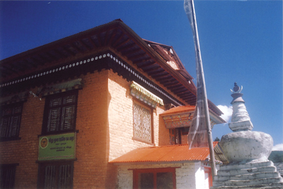
The cheese factory at Thodung
I stayed in Junbesi (meaning ‘Valley of the Moon’) at the Sherpa Guide Lodge near the west end of the village. The lodge was luxurious with huge rooms and a well appointed dining area. The daughters of the lodge owner had studied at boarding schools in Kathmandu and spoke impeccable English. The well to do sent their children to excellent and expensive schools in the city to give them a ‘good’ education and a big advantage in life.
Junbesi is regarded as one of the first Sherpa settlements in Solu Khumbu. The village has large, well appointed lodges in Sherpa homes. There is a Hillary School, a police post and shops. The old monastery in the village had been recently renovated and I was lucky to attend a Sherpa dinner celebration in the evening.
Early the next morning I set off for the huge monastery complex at Thubten Choling a two hours trek along a gently rising valley. This huge complex houses a gomba, a nunnery, monk’s quarters and a school of Tibetan medicine.
Later, after returning to the lodge, I started on my return journey home, back towards Jiri. I hoped to cross the Lamjura pass to Goyom or, if possible, as far as Sete. Alternately, a trekker can walk a few hours south from Junbesi to Phaplu, on the trail to Salleri (the district headquarter town). From Phaplu there are regular flights to Kathmandu.
While trekking back to Jiri, I diverted on the third day (the sixth full day of my trek) to Thodung, the site of Nepal’s first Swiss built cheese factory (dating to the 1950s). Roads criss-cross the hills and I started my climb to Thodung from Deorali along a newly cut road. The well built trail to Thodung intersected the road at regular intervals and soon I started using it to gain elevation more quickly. There were superb views of Gauri Shankar.
Gauri Shankar is regarded as the abode of Lord Shiva and his consort, the Goddess Parvati. The mountain is notoriously difficult to climb and was among the last to be conquered. A local legend mentioned in the book on the ‘Gauri Shankar Trekking Area’ by Patricia East and others explains why the mountain is so difficult to climb. Lord Shiva sees puny humans toiling towards the summit. Shiva gets angry and wants to send down an avalanche sweeping away the mountaineers. His wife bids him to wait as she finds the leader especially attractive and wants him to come closer so that she can make out the color of his eyes. The party comes closer and Parvati notes that the leader’s eyes are blue. She tells her Lord now you can do as you wish and Lord Shiva sends an avalanche roaring down sweeping away the mountaineers.
Guidebooks are never tired of singing the praises of Thodung and mention it as a good place to stay. I reached the Thodung monastery and then had to ask for directions repeatedly to reach the cheese factory. The factory is operated by the Dairy Development Corporation and only one variety of cheese is manufactured. I chatted with Mr. Jirel, the cheese maker, who recounted the sad tale of the place’s decline. The factory buys milk to make cheese from local farmers. The orange painted buildings were in a superb location and the cheese was exquisite. The huge Tibetan mastiff dogs about which guidebooks repeatedly warn were conspicuous by their absence. Not more than six people manned the cheese factory. The water at the factory was the best I had ever tasted, cool and pure like ambrosia of the Gods. Jirel-ji repeatedly sang praises of the air and water at Thodung, and I thought about a wonderful tourist opportunity to be exploited. But, he also spoke of the gradual demise of the cheese-making operation. At present only one variety of cheese is manufactured here; milk, yoghurt and ghiu (clarified butter) are not available.
During the long hours of the trek I had plenty of time for reflection. I was thinking that a ‘Nepal Institute’ would be a good idea. There are many problems in Nepal which can be tackled by the best Nepali and international minds. For example, how to make a good trekking shoe for the Himalayan trails? - flexible, soft, with an excellent grip and yet tough to cope with the roughest hillside? How to cut roads that last? - the hills are lashed with heavy rains and landslides destroy roads every monsoon. How to harvest rain water and use the dung of domestic animals to generate electricity? There are a number of problems which need solutions. What shape will such a ‘Nepal Institute’ take? Who will be enticed to lend affiliation to such an institute? How will it be funded? What other issues should it address? And, not least, will it ever see the light of day? These are questions which only the future can answer but I am sure if started it can play a pivotal role in improving living standards in both rural and urban Nepal.
Besides the scenery, and nice places to stay and food to eat, trekking also allows one to think deep and ponder how to solve some of the knotty problems of our age and place.
The author thanks Harish Thapa, Pharmacist at KIST Medical College for help with the trek logistics. Dr. Ravi Shankar is an avid trekker and photographer. He can be reached at ravi.dr.shankar@gmail.com.