What kind of experience will you have while trekking in Nepal? This will be the foremost
question on the mind of anyone planning to go trekking in this Himalayan country, home to eight of the world’s 14 peaks over 8,000 m. Dr. Stephen Bezruchka, a medical doctor and a frequent, long time visitor to Nepal has written a book called ‘Trekking in Nepal’. In his book, he states that a trekker in the hills around Pokhara, on waking up early and directing his/her gaze to the north, can see the triangular rock and snow face of Machhapuchhare (the fi shtail mountain) glistening in the sun through a hole in the clouds. Or you may meet a retired soldier in a remote village who speaks fl awless English. Trekking in Nepal took off in the late 60s and early 70s. A trek is basically a trip back in time for people from a competitive and technologically driven modern society. During a trek, life goes on in its slow, unhurried way; human interactions take place face-to-face over a cup of hot chiya (tea); and people enjoy doing one thing at a time.
M y preferred trekking style is either alone or with a small group of friends. I have occasionally trekked with big groups of up to 14 individuals. Over the years, I have trekked in the Annapurnas, the Everest region, Solu, Langtang and Helambu, the hills around Palpa, Pokhara and Kathmandu, and the Gaurishankar trekking area, among others. Many centuries ago, people slowly settled in the hills of Nepal. Villages were established and a network of footpaths (trails) interconnected these villages. People used to walk from village to village for various purposes and also used to go to holy places on pilgrimage. Travelers stayed in village houses or in small inns. These paths and inns grew to the trails and trekking lodges of today. In this article, I look at some of Nepal’s most popular treks, short treks (of around a day or two) and a few new and relatively untouched trekking areas.
The homeland of the Thakalis – great cooks and aficionados of fine food
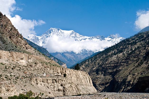
The region north of Pokhara is inhabited mainly by Thakalis and related groups who are famous as businessmen and inn keepers throughout Nepal. They run comfortable and clean lodges, and serve some of the best food you can have on a trek. The trek is popularly known as the ‘apple pie’ trail because of the dominance of this dish in lodge menus. The region can be reached in many ways. You can fly to Jomsom, take a jeep from Pokhara/Beni or walk up from Beni or Nayapul through Ghorepani. You reach Tatopani 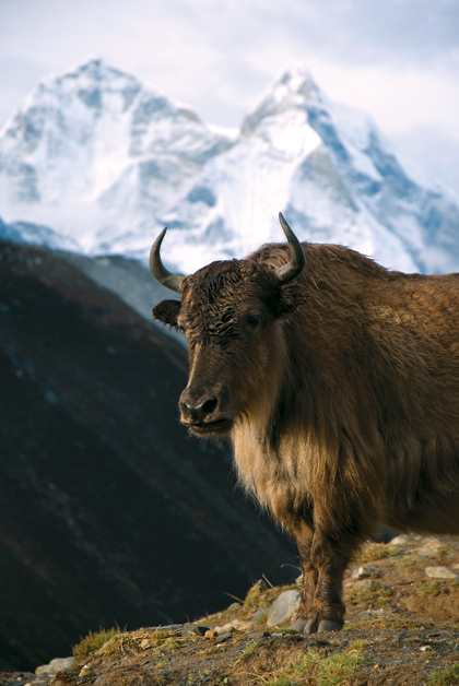 (hot water), famous for its hot springs and delightful lodges with an abundance of fresh fruits and vegetables. The trail then climbs steeply to eventually reach the villages of Lete and Kalopani. These villages have delightful lodges and a superb mountain panorama with views of both the Dhaulagiri and Annapurna Himals. The villages of Kobang and Larjung offer stupendous foreshortened views of the Dhaulagiri massif. Due to the greater heating of the air above the Tibetan plateau, a fierce wind roars along the valley every afternoon. Houses in this region have small windows and huddle behind rocks and other features as protection against the fierce wind.
Tukuche was a major trade center during the days of the salt trade with Tibet. The old and substantial houses of the merchants attest to its prosperity. I had one of my finest Thakali meals in Tukuche. Most tourists go into raptures as they describe the delights of Marpha. The town is famous for its fruits. Jeeps regularly ply to the temple of Muktinath from Jomsom. Kagbeni makes for a welcome night halt en route, and the ‘Red House’ lodge combines good food and accommodation with history having it as the converted house of a nobleman.
Starting and end points: Nayapul/Beni and Jomsom
Annapurna Base Camp – into the heart of the mountains
Annapurna Base Camp trek puts you quickly among spectacular mountains without the tedium of a long walk in or the expense of a flight. The trek starts from Nayapul (new bridge), a drop-off point on the Baglung-Beni highway. You have two options. You can either climb to Ghandruk, a beautiful Gurung village, or you can divert and climb to Chomrong. The mountain views from both these villages are spectacular. Annapurna South (Annapurna Dakshin in Nepali) dominates the landscape. Machhapuchhare is seen in its true fishtail aspect in contrast to the pyramidal Matterhorn which dominates the Pokhara skyline. Hiunchuli and Annapurna I (the first 8,000-m peak to be climbed by Maurice Herzog and his team in 1950) are also seen. From Chomrong the trail climbs up the Modi Khola valley. This region is exposed to the full force of the monsoon. The trail is likely to be wet and soggy, and bamboo grows in abundance.
The mountain views disappear except for occasional glimpses till you reach Machhapuchhare Base Camp. The region is sacred to the Gurungs and a small temple has been erected to honor the guardian deity of the place. The lodges are small and fill up quickly during the peak trekking season. I remember once when I and Dr. Brahmadathan, a microbiologist, had to occupy a room kindly vacated by an obliging cook. This is one of the few treks in Nepal with significant danger of avalanches, especially in March once the snow accumulates. Annapurna Base Camp is situated in a basin between Annapurna South and Hiunchuli and Annapurna I, Baraha Shikhar and Machhapuchhare. The views of the Annapurna South glaciers are spectacular.
Itinerary: Number of days: Seven
Starting and end points: Nayapul and the lakeside resort town of Pokhara
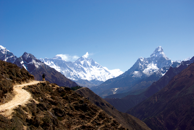
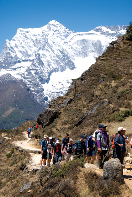
Everest Base Camp (EBC) – getting intimate with the highest mountain on Earth
Khumbu, the northern part of Solukhumbu district, is famous for some of the highest mountains on Earth and for the Sherpas of Tibetan descent who are famous as mountaineers. Most trekkers fly to the airport at Lukla, a remote mountain village and start trekking from there. The popularity of the trek can be judged from the fact that in season, Lukla is the second busiest airport in Nepal after Kathmandu. You can also walk in from Jiri, the nearest road head. The initial part of the trek is along the Dudh Koshi river valley and then climbs steeply to the large Sherpa village of Namche Bazaar. Along the way, trekkers get their first glimpse of Everest. Namche bazaar is a modern place with lodges to suit different pockets, restaurants, pizza places, bakeries and cyber cafes. I have been to Namche and beyond many times as part of research projects for the Mountain Medicine Society of Nepal. We usually stay at the Panorama lodge in the upper part of the town. The lodge has good mountain views and is famous for Rigi-Kur (thick potato pancakes) served with chutney made from Jyaan-maara khursaani (literally, life killing chilies) and Som (a pungent butter made from yak milk). Most trekkers spend an acclimatization day at Namche and go on a day trek to Syangboche and the Everest View Hotel before going higher. The Everest View Hotel offers a spectacular mountain panorama, including Everest, Nuptse, Lhotse, Lhotse Shar, Ama Dablam, Kantega and Tawachee among others.
 From Namche, it is a long climb to the monastery at Tengboche. I count myself lucky to have witnessed the dance drama of Mani Rimdu twice in the sacred precincts of the monastery. During the trek to EBC, trekkers spend more than a week at altitudes over 3,000 m. This puts them at high risk of altitude sickness. The Himalayan Rescue Association runs a trekkers’ aid post at Pheriche, a hamlet at about 4,200 m. Most trekkers climb Kala Pathar, a black notch on Pumori to obtain spectacular views of Everest. From Kala Pathar the massive black rock face of Everest is less than eight miles away. There are also spectacular close up views of Pumori and the Khumbu glacier. The base camp is a four-hour walk along the Khumbu glacier. Most tourists climb Kala Pathar but do not walk to the base camp as there are no views of Everest from there.
Itinerary: Number of days: 10 to 14 (with acclimatization days) from Lukla
Starting and end points: Lukla or the road head at Jiri. Syangboche (to which Tara Air flies) can also be a starting point. The end point of the trek is normally Lukla.
Gokyo – a series of spectacular high altitude lakes and Nepal’s longest glacier
Another delightful trek in the Everest region takes one to a series of high altitude lakes (at around 4,800 m). Fewer trekkers do this trek compared to the one to EBC. The trail diverts from the main one to EBC after Namche Bazaar. The trail climbs up to the pass of Mong La and then descends to Phortse Tenga from where you can reach Phortse, a spread out Sherpa village with comfortable lodges. Most trekkers overnight in Dole. The best place to stay used to be the Yeti Lodge and I still remember their apple custard with relish. The recommended next night’s halt is Machermo. Distances are not long and it is possible to go too high too fast in this beautiful valley. International Porter’s Progress runs an aid post in Machermo and, in season, the resident doctors give a high altitude talk every afternoon. The scenery around Machermo is spectacular. From Machermo, it is less than four hours to the Gokyo Lakes. The lodges are around the third Gokyo Lake (4,800 m) by the lateral moraine of the Ngozumpa Glacier (Nepal’s longest). Watching the play of light on the waters seated in a heated dining room drinking hot tea is a good way to while away the hours.
Most trekkers climb Gokyo Ri (4,980 m) a spectacular view point. From the summit four 8,000ers – Everest, Cho Oyu, Lhotse and Makalu – are visible. Everest is seen at a greater distance compared to the ‘intimate’ view obtained from Kala Pathar, but more of the massif itself is seen. I have a framed photo of Everest from Gokyo Ri in my apartment. A veteran trekker, Hugh Swift, recommends trekking up to the fourth and fifth Gokyo lakes. You can combine this trek with the one to EBC by crossing the Cho La pass, which gives you awesome views of Cholatse and Tawachee.
Itinerary: Number of days: Seven to 10 (with acclimatization days) from Lukla
Starting and end points: Lukla, or the road head at Jiri. Syangboche (to which Tara Air flies) can also be a starting point. End point is Lukla.
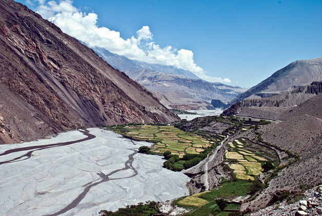
Annapurna circuit – Nepal’s classic trek
The Annapurna circuit is one of Nepal’s classic treks. The trek used to start from the village of Dumre on the Pokhara-Kathmandu highway at around 500 m. The trail steadily climbs to Thorung pass at 5,400 m. The trek goes around the Annapurna massif. A new road has been cut and is planned to eventually reach Chame, the district headquarters of Manang. The initial part of the trek is along the narrow gorge cut by the Marshyangdi. Tal, a pleasant and peaceful spot by the banks of the river, marks the entrance to Manang district. Like the Kathmandu Valley, the place was a lake when an earthquake suddenly dammed the flow of the Marshyangdi. From Chame there are good views of Lamjung Himal. The trek passes behind the Annapurnas and enters the dry east-west Manang valley at Dhikur Pokhari. The great wall of Pisang, a massive rock formation, dominates the landscape. The air is dry and bracing, and the scent of pines is in the air. Manang is one of my favorite places. There are close-up views of the ‘other side’ of the Annapurnas. The airport is at Hongde (3,400 m). In Hongde, I always used to stay at the Airport hotel and felt at home with the wonderful hospitality of Phalten didi (sister). If you are flying directly to Hongde, factor in the increased risk of altitude sickness. About half an hour from the airport, you enter the marvelous Sabje Khola valley. The views of the Himals are out of this world.
Bryaga is a village with an ancient monastery perched half way up a hill. Initially, Manangis were suspicious of foreigners but welcome tourists and their dollars with open arms these days. Manang village, at a height of around 3,600 m, is located at the base of the spectacular Gangapurna. The hotels of Manang are large and have all modern facilities. Watching videos is a favorite pastime. From Manang, you climb up to Yak Kharka (Yak pasture) and then to Thorung Phedi. It is a long and hard climb to the pass, and many trekkers stay at the High Camp lodge to make things easier on the morrow. From the pass, it is a long and steep descent to the temple town of Muktinath. The classic trek used to take around three weeks, but with the increasing penetration of roads, it may be possible to do it in about a week.
Itinerary: Number of days: Eight to 18 (depending on the starting and end point)
Starting point: Besishahar, Khudi or even Chame (with increasing road penetration)
End point: Muktinath, Jomsom, Birethanti/Nayapul (the trek is usually done anticlockwise)
Langtang – a delightful trek near the national capital
I did this spectacular trek in 2008 from Kathmandu and was the last of the major trekking regions to be explored. Syabrubesi, the starting point, is a long bus ride from the capital. The road deteriorates after Trisuli Bazaar and becomes a severe test of endurance. The first day’s halt is the settlement of Changdam also known as Lama Hotel after the first lodge built here in the 1970s. The valley begins to open out at Ghore Tabela (horse stable) at 3,000 m. There is a check post here and you can continue to the village of Langtang to spend the night. There are views of the Langtang series of peaks. Do not continue beyond Langtang, and keep in mind the possibility of altitude sickness. The village has an active monastery and I met monks from Langtang at Lama Hotel where they were conducting an exorcism ceremony. Just beyond Langtang is one of the longest mani walls I have seen. The wall stretches for around a kilometer. The houses have attractively carved wooden windows. There are spectacular views on both sides and you cross the terminal moraine of the Ledrup Lirung glacier.
Kyangjin is a big collection of lodges and is famous for its Gompa (monastery). Tilman was the first Westerner to explore the Langtang valley in the 1950s. The Kyangjin Gompa is around 400 years old. There is also a cheese factory here started in 1955 by the Swiss Association for Technical Assistance. I spent a night at a small lodge in Kyangjin. Kyangjin Ri (4,800 m) is a viewpoint near the Gompa. The upper Langtang valley was extensively explored by Tilman. Langtang, along with certain other Himalayan valleys, is known as a ‘beyul’ or a sacred valley. A yak once led a holy man here. On reaching the valley and fulfilling its destiny, the yak died. The place where the yak died is known as Langshisha Karka. Tara Air, a subsidiary of Yeti Airlines, flies to Kyangjin Gompa.
Itinerary: Number of days: Five to 10 (depending on where you start and end the trek and number of days spent in the upper Langtang valley)
Starting point: Syabrubesi or Dumre. The trek can be combined with the one to Gosainkunda or to Helambu trek by crossing the Laurebina la
Let us now turn our attention to some short (one or two-day) treks. Like all treks in Nepal these can be combined with other treks to tailor treks for the time at your disposal.
Ghandruk – home of the brave
The trek takes one to the delightful Gurung village of Ghandruk. From the lakeside resort town of Pokhara, take a vehicle to Nayapul, the trailhead for most treks in this region. From Nayapul, it is a short walk to the village of Birethanti with delightful lodges in old converted houses and sidewalk cafes along the banks of the Modi Khola. The only complaint I have about the place is the village crier who goes about beating a drum in the stillness of pre-dawn, rudely awakening people from sweet slumbers! It is a level walk along the banks of the Modi Khola to the settlement of Syauli Bazaar. The settlement sprawls along the river bank. You keep on walking for an hour, and it is still Syauli Bazaar! Soon the trail starts climbing and keeps on doing so till you reach Ghandruk. You are advised to keep your eyes to the ground and take one step at a time. Looking up to see how much of the climb is left can be very disheartening. The trail is broad and the steps well built.
There are frequent tea shops and chautaras where you can take breaks. On the other side of the river you can see the large village of Landruk and, on a clear day, there are excellent views of Machhapuchhare and the Annapurnas. Ghandruk was the headquarters of the Annapurna Conservation Area Project (ACAP), a unique experiment in letting conservation, wildlife, tourism and villages coexist, which was duplicated in many other areas of Nepal. In this village, there are Gurung museums that showcase the lifestyle and culture of this ethnic group who won fame as brave warriors and are in demand in armies and police forces. One of my favorite lodges is the Himalaya lodge at the top of the village. This lodge, built in a traditional style, is a Kerr and Downey resort but occasionally takes in independent trekkers. From Ghandruk you can continue to the Annapurna Sanctuary, divert to Ghorepani or Chomrong or return to Pokhara. The other route to Ghandruk is from Dhampus through Landruk.
Ghorepani – a superb Himalayan viewpoint
Ghorepani and Poon Hill are popular treks from Pokhara. The initial part of the trek is along the Bhurungdi Khola. The clear blue waters of this river are in striking contrast to the white glacial silt carried by the Modi. There are pleasant waterfalls and pools. The trail soon begins to climb steeply on stone stairways. Hille, Tirkhedhunga are settlements along the way. After Tirkhedhunga, the fun starts according to Hugh Swift, a famous trekker and author. He writes, “Get out a handkerchief, unfurl your umbrella, and begin the steep climb to the clustered, slate-roofed town of Ulleri.” On my first visit to Ghorepani with a team of doctors from Manipal Medical College, I had overnighted at Ulleri.
After Ulleri, the climb become less steep and enters rhododendron country. Ghorepani has grown considerably from a single lodge to a huge cluster offering all facilities to tourists. There is even a discotheque to while away the blues. Most tourists stay at Deurali (pass) at about 2,800 m. I usually stay at Snow Land which offers delightful views of the Annapurnas and Dhaulagiri Himals. If you are not tired from the long climb to reach Deurali, you can walk up to Poon Hill to catch the sunset. The hill is named after Major Poon, a retired soldier who built a trail and publicized this excellent view point. Poons and Magars are the major ethnic groups. During the peak trekking season in autumn, trekkers throng the place. The views of the Dhaulagiri massif, the Nilgiris, Annapurna South, Hiunchuli, Annapurna I and Machhapuchhare are excellent.
Chisopani – the entrance to the Helambu region:
This is an excellent short trek near Kathmandu. The trail starts from Sundarijal at the northern outskirts of Kathmandu where there is a large drinking water project. The trail climbs steeply along a large water pipe. The hill is delightfully wooded with many waterfalls. Being near the capital, it is popular with young couples seeking privacy and each other’s company. The first village reached is the Tamang settlement of Mulkharka. The place has a panoramic view of the Kathmandu Valley and you can watch planes taking off and landing at the Tribhuvan International airport. It is a wonderful feeling to watch the hustle and bustle and the urban sprawl of Kathmandu and yet be away and detached from it all. The trek enters the Shivapuri National Park, and all foreigners have to pay an entrance fee of Rs. 250. The trail climbs to the settlement of Chisopani where there are three or four lodges. Mr. Rameshwar Khadka, a tourism consultant, is developing the region for home stay and cultural tourism. From Chisopani, there are good mountain views in the early morning and the hills are ablaze with rhododendrons in bloom in spring.
Pulchowki – the highest point overlooking the Kathmandu Valley
Pulchowki, at around 2,700 m, is the highest point in the hills surrounding the Kathmandu Valley. Pulchowki literally means the place of flowers. Godavari, at the southern end of the valley, is a peaceful and pristine place. Microbuses to Godavari are available from the Lagankhel bus park in Patan. I climbed to Pulchowki along with my friend, Mr. Acish Banstola on a cold and cloudy February morning. It had rained heavily the previous night and the shortcut trail was wet and slippery. Locals advised us to follow the vehicle road to the top. The road winds past the Pulchowki Mai temple and St. Xavier’s School. The hills are densely wooded and rich in birdlife. There is a stone quarry that contributes significantly to the local economy but disfigures the landscape. The botanical gardens can be seen far below. The small temple at the top of the hill is popular with devotees who combine a pilgrimage with a picnic. The area near the top is a military installation and signs warn worshippers and trekkers to stay on the road and not wander to the sides which are mined. The summit has a huge communication tower and is often wrapped in clouds. The mountain views on a clear day can be outstanding.
Dhulikhel-Namobuddha-Panauti circuit
Dhulikhel, a well preserved town as well as a mountain viewpoint, is an hour’s drive from Kathmandu along the Arniko Highway to Kodari and Tibet. Dhulikhel Lodge, one of the budget lodges in the place, has popularized the Namobuddha circuit. The book, ‘Nepal the rough guide’, states that the walk has probably been over hyped. The full circuit takes most of the day. Namobuddha ranks high up in the hierarchy of holy sites for Tibetans in Nepal. The stupa is about two and half hours’ walk south of Dhulikhel and rests on a red earth ledge. There is a famous stone relief sculpture depicting the legend of Namobuddha. Buddha, in one of his previous lives as a hunter, encountered a starving tigress and her cubs. Moved by compassion the Buddha offered his own flesh to the tigress as a sacrifice. From Namobuddha, you can continue onto the temple town of Panauti. You can return from Panauti to Lalitpur through Lakhuri Bhanjyang and Lubhu.
Having looked at the popular routes and short treks, let us turn our attention to new trekking routes and less explored ones.
The Gauri Shankar trekking area
A new trekking area has been developed to the west of the Everest region by an Austrian NGO called Eco Himal with the help of the local people. Treks of varying durations can be carried out. I did a five-day trip in this region last October. I started from Barabhise on the Arniko highway and walked to Singati, staying in community owned lodges along the way. Bigu, with its nunnery and Gompa, is a key attraction. From Singati, you can also trek to Orang, Gongar Khola and Simigaon along the Bhote Koshi and eventually join the Rolwaling trek. This is an area near Kathmandu waiting to be discovered.
Jiri – the forgotten entry point to Everest
Jiri is the road head to the Everest region, and trekkers can reach Namche Bazaar in a week. This trek proceeds west to east and cuts across river valleys that flow north to south. You climb hills to the summit and then descend to the river valley on the other side. The trek is strenuous but passes through delightful villages. Good accommodation is not hard to find as only few individuals do this trek. Junbesi, a Sherpa village has some outstanding lodges.
There are many treks which I have not been able to cover. Treks in western Nepal like the one to Rara Lake, Humla, Jumla, Shey-Phoksundo Lake, Khaptad National Park, the trek around Dhaulagiri, around Manaslu, Kanchenjunga treks, the Chepang hill trail, the Arun valley treks are among these. Some have been covered in previous issues of ECS Nepal. Nepal is a trekker’s paradise. With its mountainous topography, high Himalayas, rich culture and delightful people, trekkers keep coming to Nepal again and again. With increasing development and construction of roads ever deeper into the hills, certain treks of yore are becoming the jeep or bus journey of today. Should roads extend deeper and deeper into trekking areas? Should trekkers be deprived of the joys of a rich and simple life? Should locals not have access to modern healthcare, easy transportation facilities and bigger markets to sell their produce? Many questions remain. The challenge is to help locals find acceptable solutions and make informed decisions about the problems facing them.