An informative feature on how glaciers are undergoing drastic transformation in the Himalayas.
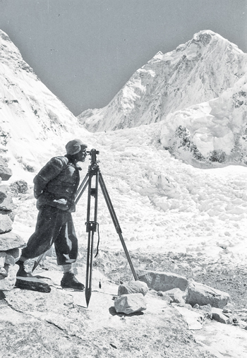
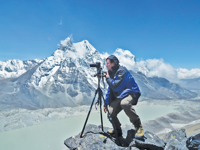 Pema Temba Sherpa climbed steadily up the snow covered rock scree toward his destination, a rock cairn constructed by some mountaineer or scientist long ago, in a remote region of Nepal’s Sagarmatha (Mt. Everest) National Park in eastern Nepal. Even at 5,500 m, the world’s highest mountains rose majestically for thousands of meters on all sides, and made him feel small and vulnerable.
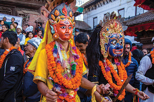
 Pema was born in the Everest region, a member of the Sherpa ethnic group famous for their mountaineering skills, reliability, and friendly disposition. Although he had summited Everest twice in his former career as a climbing Sherpa, the light snow from the night before made what would have normally been a simple scramble into a slippery, dangerous, and exposed climb. Having neither a rope nor climbing equipment that day, a slip would have sent both of us plummeting thousands of meters to our deaths on the glaciers, boulders, and scree slopes below.
 Realizing that it would be foolhardy to proceed under these conditions, I called out to Pema to stop, that this point and altitude (just 100 m below the cairn) were good enough for the objectives at hand. Those objectives included the replication of a panoramic photograph taken of the Imja glacier below us by climber-cartographer Erwin Schneider in 1955, the cairn being a landmark that he had constructed to mark the location of his photo point.
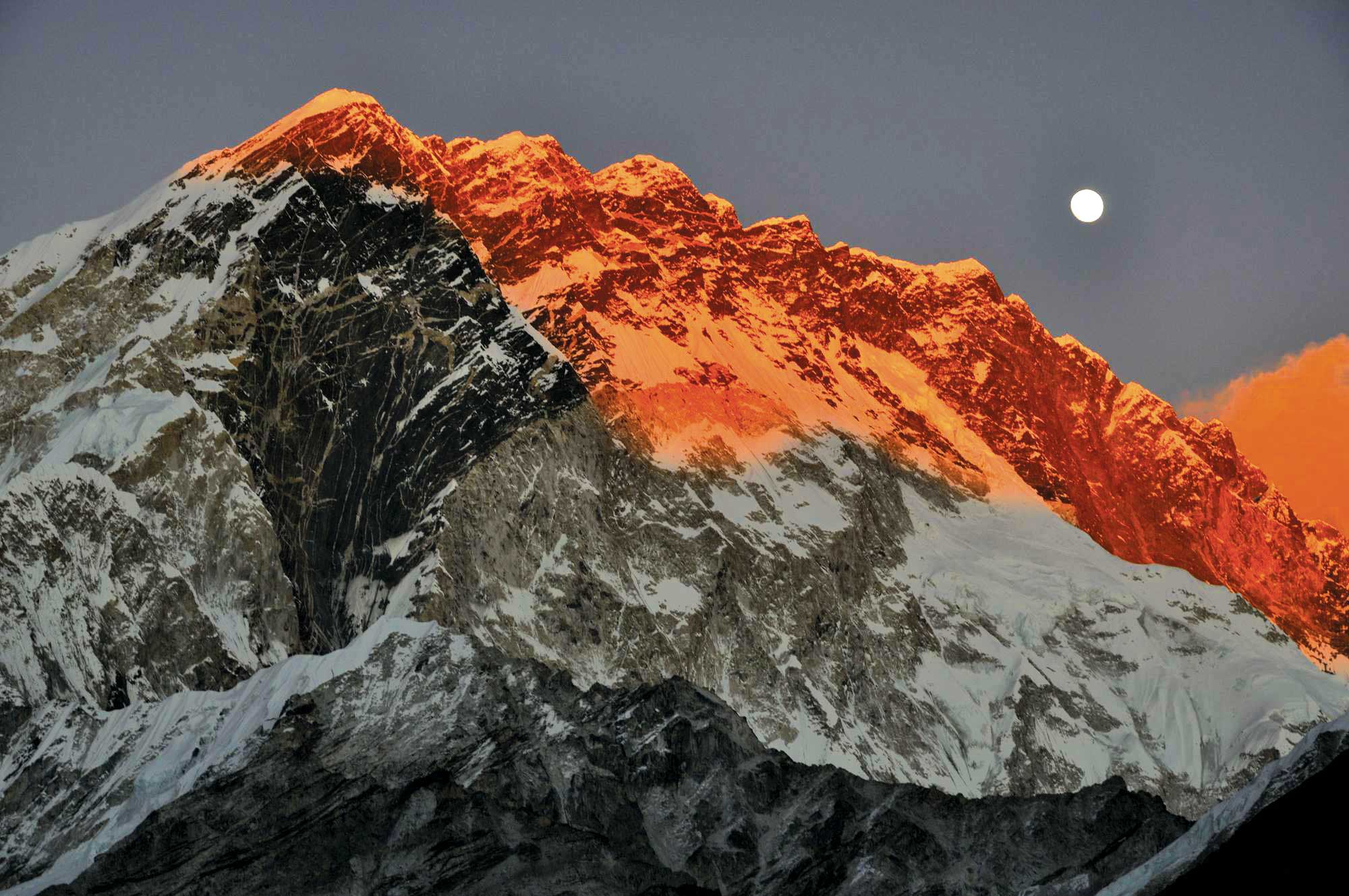
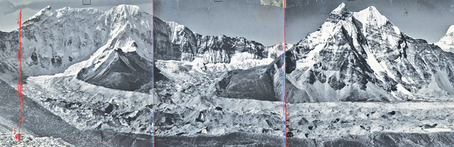
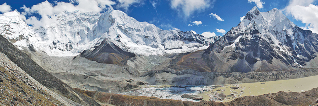
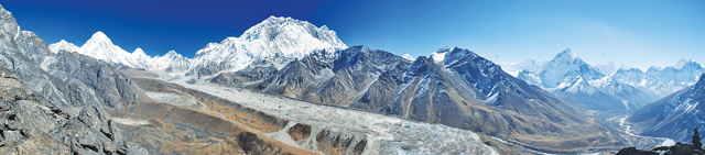
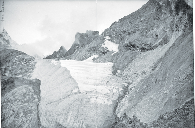
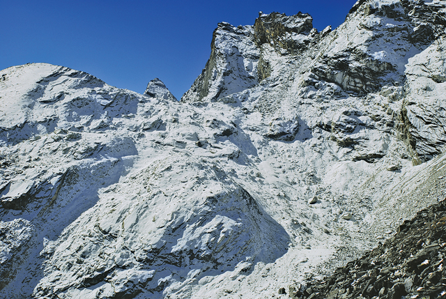
 Even though we were unable to stand at the exact point where Schneider’s photograph was taken, our view of the glacier and surrounding ice-clad peaks was unobstructed. But, in looking at the old photograph (Figure 2), and then the view in front of me now (Figure 3), it was clear that something was dramatically different from the scene that greeted Schneider nearly 60 years ago and the one that greeted me now. The Imja glacier that I had hoped to re-photograph was gone, replaced by a lake about 2 km long and 0.5 km wide, a maximum depth of over 100 m, and holding some 65 million cubic meters of water. Boat to house-size ice bergs that had broken off from the remaining glacier terminus floated aimlessly in the water. In the interim period between Schneider’s cartographic expeditions between 1955 and 1961, and my climate change research in 2007, the glacier had melted and left behind a large, and potentially dangerous, lake in its place.
Climate Change and Mountains
Global climatic change during the twentieth century has had a tremendous impact on the world’s mountain glaciers, particularly in the form of glacial recession and/or disappearance. According to the World Glacier Monitoring Service (WGMS), glaciers are now shrinking three times faster than they were in 1980 because of increases in global temperatures.
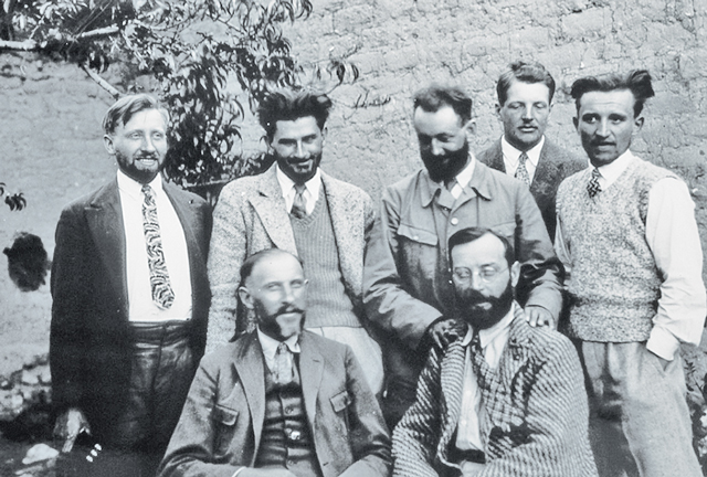
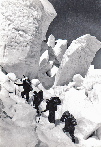
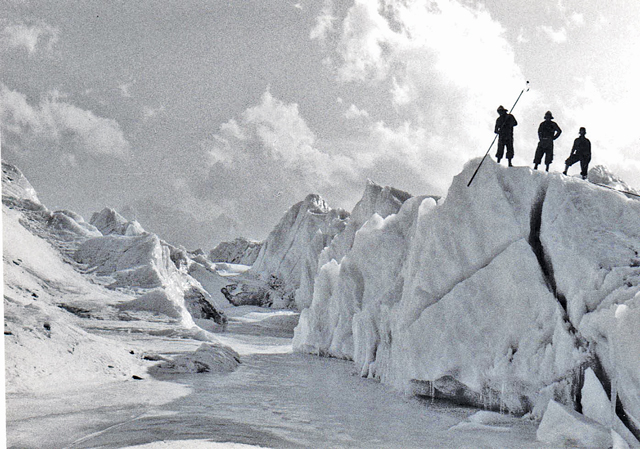
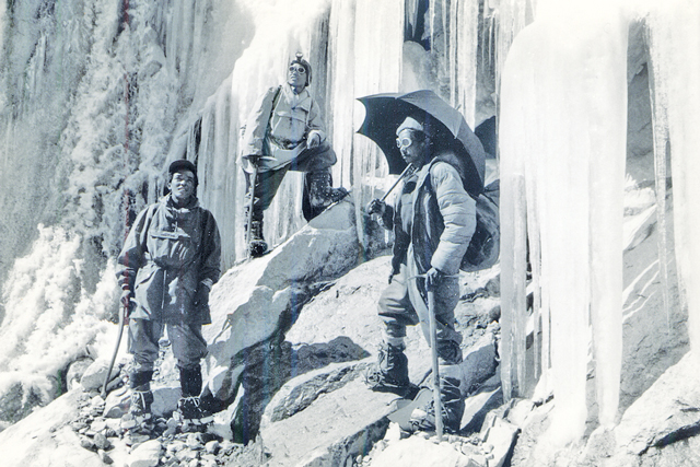
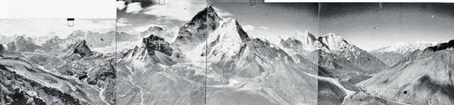
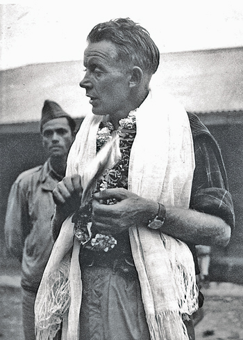 In 2005, the famous mountain geographer Dr. Jack D. Ives, my advisor and mentor during my graduate school days, had given me a box of old photographs collected by his friend and colleague Professor Fritz Müller, a Swiss-Canadian glaciologist and chief scientist for the 1956 Swiss Everest expedition (Figure 4). The box also contained glacier photographs taken by Sir Charles Evans, deputy director of the 1953 Everest expedition (Figure 5); and the 1955 glacier panoramas of Erwin Schneider (Figure 6), a climber-cartographer who later made the beautiful Alpenverinskarte maps of the Khumbu and other regions of Nepal. Müller, who lived near Gorak Shep (5,140 m) for nine months, also took numerous photographs of his Sherpa research assistants in the course of his work, whom I like to refer to as the first Sherpa “climber-scientists” (Figures 7 and 8). Realizing that these historic photographs could provide an unprecedented window into the past, I became deeply interested in learning more about the impacts of climate change on the world›s highest mountains from the perspectives of these early western climber-scientists. Beginning in 2007, I was to retrace their footsteps in some part of the national park every year afterwards, climbing to the peaks, high passes, and cairns from which they took their photographs over 60 years ago.
 Changes
Finding the original photo points was the first challenge, however, as there were no geographical positioning systems (GPS) when Müller, Schneider, and Evans took their photographs, and no records of their geographical coordinates were known to exist. But we were eventually able to find nearly all of the photo points through a combination of our own familiarity with the landscapes, the suggestions of climbing guides and yak herders, and luck (although some still have me mystified to this day as to where they could have possibly been taken from).
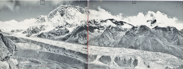
 Receding glaciers and new glacial lakes were not the only changes I encountered and studied over the next several weeks and years, as a range of phenomena were in progress, most impossible to detect by remote sensing alone. The Imja glacier, we learned, had melted so rapidly because it had been covered by a thin layer—less than one meter in most places--of soil and rocks that would heat up during the day, and then transfer the heat directly to the ice below (glaciers become debris covered when they begin to stagnate and cease their forward movement, which has been the case in the Everest region since the end of the «Little Ice Age» in the late 1800s. Over time, boulders, rocks, soil, and other debris from the valley and lateral moraine sides cascade downward and cover the ice, in varying thicknesses). Most other glaciers in the Everest region, however, such as the Khumbu glacier (Figures 9 and 10) contain a thick (3 m+) cover of debris, some with boulders the size of small houses that has tended to insulate them from the sun›s heat. These glaciers have nevertheless «ablated,» or lost mass, over the years as shown by the abundance of new, small meltwater ponds on their surface; and obvious loss of any clean glacier ice that happened to be exposed. The growth of these ponds appears to have accelerated in recent years, and these will clearly be the glacial lakes of the future in the Khumbu.
On the other hand, the smaller, lower altitude, “clean glaciers” had either lost most of their mass in the interim, or had melted away entirely. When Mller crossed the Kongma La (5,535 m) pass in 1956, the Pokhalde glacier was healthy and stable (Figure 11). When I arrived in 2007, it was gone (Figure 12). Using time lapse repeat satellite imagery, the International Centre for Integrated Mountain Development (ICIMOD) has determined that hundreds of these small, clean glaciers have disappeared in the Khumbu region since the 1970s1.
Ice above 7,000 m, however, appeared to be remaining relatively stable, since at these high elevations temperatures remain below freezing throughout the year. Such high elevation ice and glaciers with north-facing aspects appear to have changed little during the past 60 years (Figures 11 and 12), although glaciers with warmer south-facing aspects tended to show more signs of melting, recession, and loss of ice.

In summary, the glaciers of the Mt. Everest region are changing rapidly, but not all at the same time, nor at the same rate. As the glaciologist Jeff Kargel says, “…the real world of glaciers and their environment may be likened to a photographic montage in which each montage element [individual glacier] is itself a complex and dynamic picture,” each changing for different reasons related to aspect, altitude, slope, or debris cover. Some are gone, some will be gone soon, and some will be around for a long, long time.
 Nevertheless, in the 1950s, Evans, Müller, and Schneider were probably more frightened by the prospect of a possible return of a “Little Ice Age” and colder times,which much of Europe was still recovering from when they were young men, than what to them would have seemed like the highly unlikely possibility of increasing temperatures, especially in the world’s highest mountains. In fact, that is exactly what happened, creating changes in climate, glaciers, people’s lives, and people’s livelihoods that were scarcely imagined as recently as 15 years ago.
 Note: This article is excerpted from Dr. Byers’ new book, “CHANGE: 60 Years of Culture, Climate, and Landscape Change in the Sagarmatha (Mt. Everest) National Park, Nepal.”
 Acknowledgements
The author would like to gratefully acknowledge Dr. Jack D. Ives for his gift of the Müller photographic archives; Ms. Hanna Schneider for permission to use photographs from the Erwin Schneider Archives; and Mr. Martin Achrainer, Österreichischer Alpenverein, Historisches Archiv, Innsbruck, for permission to use the Erwin Schneider 1955 glacier panoramas.