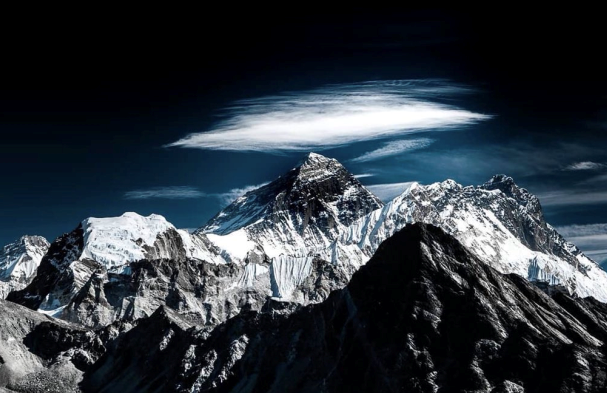
With a top New Zealand expert working with the Nepali government to remeasure the world’s tallest mountain post-earthquake, will 8848 still be the magic number?
Last week, I heard the news that the government of New Zealand will collaborate with Nepal to remeasure Mt. Everest, or Sagarmatha. The mountain’s official height of 8848 m, or 29,029 ft, was established after a 1955 survey, and while there have been other figures mentioned over the years, it was only really after the 2015 earthquake that those figures were seriously brought into question. So, a new survey is clearly needed. I was curious to get more details about the plan and the process the team will use to go about their work. Lisa Choegyal, the New Zealand Honorary Consul to Nepal, was generous enough to answer my questions, and I think that you’ll find her answers as fascinating as I did.
Q: I've recently read that the New Zealand government is going to work with the Nepali government to remeasure Mt. Everest. Can you tell us why remeasuring Everest is important?
It’s important to know the exact height of the highest point on earth, don’t you think? Mount Everest’s height has not been accurately checked in a collaborative effort for some time, and not since the 2015 earthquakes changed the country’s horizontal and vertical elevations and disrupted communication points. Last year, the Survey Department of the Ministry of Land Management, Cooperatives and Poverty Alleviation, who are in charge of such things, called a major international meeting with all the concerned parties and countries to announce their intention to remeasure Mt. Everest. Of course, China and India both have a keen interest. We were honored that Nepal invited New Zealand and Dr. Chris Pearson from Otago University to stand by them as a neutral party to help with their scientific best practice for this ambitious project.
Q: Dr. Chris Pearson, a New Zealand geodist, will be spearheading the operation. What exactly is a geodesist, and how does he plan to go about remeasuring the mountain?
A geodist is a specialist who calculates the distance between two latitude and longitude coordinates, the science of measuring and understanding the earth's geometric shape, orientation in space, and gravity field.
"Just to start out with some basic principles,” Dr. Pearson told me, "there are two ways that surveyors have to measure the height of a mountain like Mt. Everest. The first is to conduct a triangulation survey where we set up instruments called theodolites on points with known positions (latitude and longitude) and heights. By measuring angles from at least two points for rays pointing to the summits and seeing where the rays intersect, we can determine the position of the summit. Obviously, it is the inclination of the rays above the horizon that tell us about the height of the mountain. This is the way the height of Mt. Everest was determined by the Survey of India in George Everest's time. There are problems using this technique accurately. First, we need to know the coordinates of points that are close enough to see Mt. Everest, and currently there are no suitable points that are close enough to see Mt. Everest and have reliable coordinates. So, we need to do some surveying to establish coordinates for our set-up points, and this will require surveying, basically leveling from points with known heights in Nepal's sea level datum and GPS. The second way is just to take a GPS receiver to the top of the mountain and use that to determine the height. Of course, that means that someone will have to take a GPS receiver to the top and eventually take it down, which is a non-trivial task in the case of Mt. Everest. Currently, the plan is to use both of these techniques in parallel.”
Q: Wow, that is truly fascinating—I’ve always wondered how that was done. Now, just how did the New Zealand government decide to get involved with this?
Being a small country whose aid budget is mainly focused on the Pacific, New Zealand is able to support only carefully targeted programs in which our expertise can be leveraged to make a positive contribution. In addition to the Himalayan Trust, university scholarships, and mountaineering and ecotourism, New Zealand has a long relationship helping Nepal develop safety guidelines and earthquake engineering expertise for over 25 years.
As you know, New Zealand is also located on seismologically active faults and subject to many earth movements, so we have particular experience in this area. After the 2015 disaster, and at the specific invitation of the then-Minister of Urban Development, the New Zealand government provided several teams of seismic engineers and training in environmental demolition techniques to work alongside Nepal’s experts in these fields as part of our rebuilding support.
At the same time, research scientist Prof. Roger Bilham, seismologist from the University of Colorado, and the guru of Himalayan earthquakes, recommended to Nepal's National Planning Commission that the one person in the world who could help realign the disturbed network communication points was geodist Dr. Christopher Pearson.
At the invitation of the Nepal government, and financially supported by the New Zealand embassy, Dr. Pearson led a successful post-earthquake survey mapping project along with Nepal's Survey Department from 2015 to 2017 to help the country rebuild after the two massive earthquakes. The earthquakes caused the ground to move by about two meters in some places, sending coordinates in geographic information system and geodetic databases "well off'' their actual locations. Mathematical models had to be developed to correct coordinates and survey measurements for the quake-induced ground movement.
Over the past three years, Dr. Pearson has been working with the Survey Department experts to develop an alternative datum that contains models for the recent earthquakes and ongoing deformation associated with Nepal’s location on the India/Asia plate boundary. Along with the model, he has developed a suite of software to convert coordinates and adjust survey measurements while correcting for the effects of the earthquakes, and these will be employed in analyzing the Everest data. In addition, Trimble NZ, the Christchurch-based technology company specializing in navigation and positioning equipment, has donated a complimentary license of their GPS processing software for use in analyzing the data collected during the project. They also plan to lend two state-of-the-art GPS receivers to Nepal for use during the summit measurement.
During these visits, a close professional relationship developed that led to the Survey Department to again invite New Zealand and Dr. Pearson to help them with the remeasuring of Mt. Everest. We were delighted to accept helping Nepal with this prestigious task.
Mr. Niraj Manandhar, Deputy Director General of Geodetic Survey Division, Survey Department, said, “We are absolutely delighted to have New Zealand’s help and collaboration, and Dr. Chris Pearson’s expertise has been very valuable to our department.”
Q: Your government has long-standing ties with Nepal; any plans for the future?
The strength of the Nepal-New Zealand relationship is based on the amazing legacy of Sir Edmund Hillary and his Himalayan Trust. Next year, 2019, is the 100-year anniversary of his birth, so it is fitting that the results of the remeasuring of Mt. Everest will be announced next year. We are also planning other events to celebrate the centenary, including some high-level visits, arts exchanges, and the publication of an Everest book by photographer Sujoy Das and myself.