Kalinchok? Beware! she declared. Isolated and heavily forested, she meant that the trail to Kalinchok is fraught with unthinkable hardships and danger. “And mind you,” she went on,” it’s not safe at all if you’re planning to go by yourselves. Wayfarers get looted and even abducted there.” It was my 83 year old mother telling me all this with an admonishing wave of her hand. Despite my every attempt to comfort her fears, she wouldn’t buy it. It’s no surprise if the mere mention of Kalinchok evokes emotions of awe, dread, and reverence among the inhabitants of the hilly countryside, in Dolakha and Charikot and other nearby villages.
My wife, my daughter and I made the trip to Kalinchok over the Dashain holidays in the first week of October. It was both a pleasure trek and a pilgrimage. Getting to the starting point, the town of Charikot, is a 133 kilometer drive northeast of Kathmandu. First, there was the five hour drive on the Chinese built Arniko Highway. At the bustling settlement of Khadi Chaur overlooking the Sun Kosi river we joined the narrower Swiss-engineered road to Jiri, the Pasang Lamu Highway.
Kalinchok is a day’s trek north of Charikot (at 1,733m elevation). The religious site is named after the famed Bhagwati temple and is nestled on the crest of a mountain, at an altitude of 3,782m (12,586ft).
After a few days stay at our ancestral town of Dolakha, four kilometers from Charikot, we were all set to begin the trek. Keeping in mind my mom’s admonitions, we chose Surya and Robin, two of my straggling cousins, locals from Dolakha, as our escorts. Alina , a niece aged 15 and Aleen a nephew aged 12 also joined us at the last moment. Quite a bunch we struck.
As we left the settlements of Charikot behind, the trail led uphill through terraced fields, some with millet stalks and some yellow flowering mustard, while bamboos and pine trees could be seen along the trail. Over our shoulders to the south, the Charikot ridge receded into a gully with a spectacular view of the river Tama Koshi in the distance. Unfortunately, we were not so lucky with the northeastern view as heavy clouds blanketed the Himalayan range, including Mount Gauri Shanker (7,134m, or 23,742ft).
We came across the first signs of habitation at a place called Chothang, also known as Hotel Danda. It seemed to belie its name, however, as no ‘hotel’ (tea shops in villages) could be seen. Instead a number of short stone steles along the trail caught my eyes with what looked like Tibetan inscriptions. We asked about their significance, and a local fellow told us that they served as memorials to pay tribute to departed souls. We also came across some stupas (chortens) with similar commemoratives scrawled on them in Devanagri script. We were informed that the Tamangs, Sherpas, Magars and Lamas commonly observe this practice.
As we pushed on and up the vegetation changed with the gain in altitude –pine and rhododendron began to dominate the landscape. We were now entering thick woods. The pine forest lining the track sprawled out left and right of us, rising to the heights as far as we could see. Then the trail opened up in a clearing and what greeted our eyes made all of us gape–a small pool called Simpani. The water was moss green, in almost a heart shape. It was next to the trail with the surrounding verdant pines beautifying the vista. An intriguing blend–picture perfect. While my wife and the rest of the gang “ooh-ed” and “aha-ed” at the sight, I busied myself with the camera.
A half hour after Simpani we reached Deurali (2,350m, or 7,820 ft). We rested there, and had a cup of hot tea. A handful of makeshift shacks owned by Magar families served tea, meals and sundry in this little settlement. The track forked here, with trails winding down to Makaibari, Chhyamawati and a small village called Shuspa, known for the small ethnic group called Thami (or Thagmi). The chill in the air was quite perceptible as our bodies cooled down during the rest. From Deurali we went on another two hours or so to Thangsa and Gairidanda. Thangsa was nothing more than two or three shacks, one of which served chang (local rice beer) and kodo ko rakshi (millet liquor).
A half hour later we approached Gairidanda, ‘Gairi’ for short. Perched high up in a mountain clearing, Gairi at 2,540m (8,453ft) commands an unobstructed view of the northeastern range, but luck still eluded us. All we saw was a cloud bank. As if to compensate, however, and much to the delight of my daughter Bulbul, Alina and Aleen, we saw our first chauri (a yak/cow crossbreed).
Gairi is considered as the last resting point and a place for something to eat, as there is no habitation for the next four hours; only a grueling uphill stretch before the night stopover at Kuri Kharka (a kharka is a high pasture). Gairi had five or six huts where we could buy chang, or chauri milk and other eatables like noodles and dal-bhat (lentils and rice). If you relish dried yak meat, they’ll serve it to you here grilled in a pan to your liking. We tried tea prepared in chauri milk, which tasted as refreshing as the smiling Sherpa ladies who served them.
The Sherpas who inhabit these small high settlements impressed us with their domestic production of chhurpi (a kind of hardened cheese made out of chauri cow’s milk). The cheese ‘factories’ were small goths (shepherd huts) with fresh chhurpi hanging in bunches from the ceiling. The kids and my daughter were on a rampage, munching the fresh factory-soft chhurpi.
What stuck out clearly in the villages of Chothang, Deurali, Thangsa and Gairi, something that seemed strange to us this far up on our journey, was the dominance of the women folk. We hardly noticed any men around. When asked, the Sherpa ladies at the teashop in Gairi informed Radhika, my wife, that some were drawn to the cities while most of them had gone the overseas for work, part of Nepal’s modern remittance culture. The Sherpas from Gairi and Chothang relocate their goths and dwellings to lower altitudes before the onset of snow each winter. After Gairi, the trail led upwards through dense temperate to sub-alpine mixed coniferous and deciduous forest, largely of blue chir pine, blue pine, hemlock and two kinds of oak along with the omnipresent rhododendron, which Nepalis call laligurans and chimal. Also very prominent was a high tension electricity line that ran alongside the trail. As we gained altitude, Radhika, a shade portly and contrary to my expectations, seemed to manage fairly well. Bulbul, 20 years old, appeared effortless. It turns out that I was the one doing most of the panting.
Lekh lagne or its peer ‘altitude sickness’ on the Kalinchok route is not uncommon. As a preventive measure, the locals have come up with an age-old indigenous treatment. It is said that eating raw garlic and sattu (finely ground roasted corn flour) guards you against altitude sickness. We had no sattu, but garlic pods were for the taking. So we sucked and munched on garlic as we continued upwards.
Isolated and quiet, the forest got denser as we progressed up the unending ascent. The farther we went through the forest, the more logs we found strewn along the trail, many freshly felled, including some older ones left to decay. It looked as if the unscrupulous loggers had gone on a rampage. When we asked about it, a villager replied: “Ke garne? (What to do?). It’s been going on for a long time, but the government has turned its back.” Some of the stumps, almost three feet in girth, must have been almost 100 years old. I’ve read somewhere that high altitude forests are very slow to regenerate.
Four hours uphill at a stretch is no joke, especially for the city-bred, like us. Our climb continued, but with many short rest. My wife, though least expected, seemed to take it in stride, trekking along making it look effortless, holding a stout branch which served as a staff. Off and on I peered to the northeast through the gaps in the woods hoping to get a glimpse of the snowy peaks. Nothing doing: the clouds still blocked the view.
After what seemed ages, we sighed with relief when the path leveled off a ridge with a stone deity by the side of the trail. This spot was called the Ganesh Twapper, after which the trail descended into a small valley. And at the far end we could see a chorten and small wooden shacks lining the track on two sides. “That,” announced a beaming Robin “is Kuri, our stop-over for the night.” Situated at an altitude of 3,200m (10,650 ft), the settlement consisted of 15 to 20 wooden shacks. The Kuri basin with the towering Kalinchok bluff ahead, the grassy slopes and the pine forested mountains to the south, also boast of two rivulets called the Bhadrawati and the Rudrawati.
It was almost 5:30 in the evening, after nearly an eight hours walk when we set foot on Kuri. A slight drizzle greeted us at Kuri followed by the hail-stones. For shelter, we ducked into the doorways of the shacks which served as guest houses. The temperature dropped quickly, and the hailstones and rain continued for a half hour before letting up.
We were looking forward to the warmth and safety of one of those lodges when a bewildered Surya brings word that none of them, normally vacant throughout the trekking season, had room for us. What with the kids and the ladies to think about, the idea of a night bivouac out in that near freezing temperature was more than we had bargained for. After a frantic scurrying around, Surya and Robin managed to find accommodation for us in a goth (cow shed) next to a monastery. For beds we made the most of some wooden planks and shared blankets, mats and whatever the boys scrounged from the monastery and from one of the full-up lodges. After supper at the lodge, we retired to our not-so-comfortable beds, all seven of us huddling close together. If anyone looked ruffled, it was I; the kids and the rest took our situation bravely and went on to joke and jest late into the night before falling asleep. Lesson learned: stop early to be sure you have a comfortable place to stay for the night.
The next morning we were up at 6:30, ready to make the final assault, which would take close to two hours trekking. What we had missed the evening before, due to the failing light, now loomed up ahead of us, soaring into the sky in all its grandeur. As we craned our necks in awe at the twin crests that jutted up above us, we could make out the faint outline of the Bhagwati temple perched on one of the hill tops. More prominent was a cottage that my cousin informed me was a pati (resting place) for pilgrims.
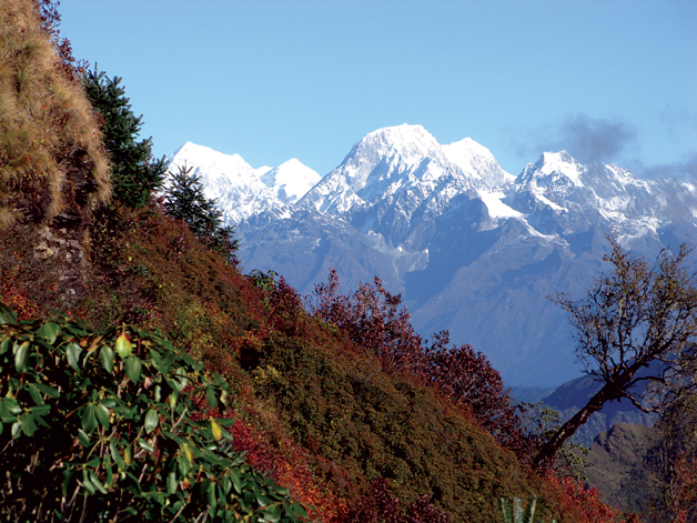
The sun was up and the morning was crisp, with a tangible chill in the air. The trail running across the mountain face began with bare grassland with hardly any trees or scrub in sight, with a sheer drop into a ravine to our left. To our right the deeply forested mountains stretched as far as we could see. As the track got steeper and slower, we moved at a slow pace. Save for the kids and my young cousins, the altitude seemed to catch up to us, as my wife’s and my own breathing now became laborious. It was obvious that we were getting past the 10,000 foot mark. During the climb we moved past the remains of last night’s still unthawed hail scattered around the mountainside. Further on the terrain changed into more cliff faces, bluffs and dry scrubland strewn with rocks and boulders. The northwest, gave me ample opportunity for pictures of the snowy range, but I longed to see Gauri Shankar peak in the northeast, still blocked from view by the mountain flank we were ascending. Only after we reached the high ridge top did we finally get an unobstructed view of the Himalayas.
Although partly shielded by a big mass of cloud, there she stood, the incredible goddess mountain, Gauri Shankar, towering over the rest of the snow clad peaks that undulated from right to left. Next to her, on the right, partly visible, was the Melungtse Himal. A magnificent sight. Fearing the clouds might interfere again, I hurriedly kept clicking the camera at the majestic Gauri Shankar.
Now we had only about 200 meters left for the final climb. A steep path led up to one of the twin buttes with the Kalinchok temple visible from the ridge we were on. Just then we spotted a group of people descending the path. “Now this,” my cousin informed us, “is the exit path. But under no circumstances is it supposed to be attempted as an entry point.” To my “Why?” he simply explained that that’s how it was, and none would dare defy and face the wrath of Goddess Kalinchok.
We had a problem. The track ahead narrowed down precariously, with only the mountain wall to our right as support while an escarpment to the left dropped into a deep gully that was terrifying to look down at. “God, I really can’t make it. How am I supposed to walk across when I can barely keep my eyes open?” Radhika protested. She had done fine to this point, but now she was almost on all fours. She hated the heights. Bravo!–hand led by Surya she made it safely to the first summit and across the iron stairway that bridged the twin summits on the two sides of a gaping chasm. Our spirits rose as we clambered up the final rungs of the iron stairway to the top.
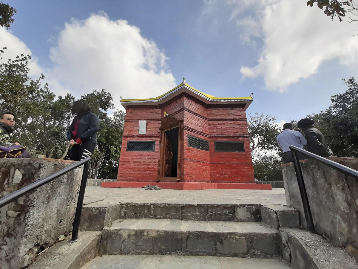
The moment we set foot on the crest, I saw that the flat area extending east to west hardly measured to 200 square feet. An iron railing fenced in the steep sides around the shrine. As we approached nearer I noticed a fenced-in area festooned with a mass of metal tridents. The tridents offered by the devotees to Goddess Kalinchcok are said to bring divine blessings. Contrary to our expectations, and much to our dismay, we learned that this age-old deity of Kalinchok Bhagwati was not to be seen in the form of an idol. A small enclosed area with a three foot deep small pit with a natural spring is worshipped by all as the revered Goddess Kalinchok Bhagwati. While a horde of bells and tridents adorn the entrance to this pit, and a pair of bronze lions stand sentinel. The only thing that offended our senses was the hideous looking collapsible iron gate in front of the main shrine. There was also a stone pillar, an altar with the idol of Ganesh where devotees sacrifice goats, ducks and chicken, and a blood swathed stone idol of Kali Bhagwati garlanded with animal intestine. This idol is said to have been erected at a later time.
With puja (worship) over, we took time off to unwind, almost neck to neck with the clouds, gazing at the breathtaking panorama every which way we looked. Even as I marveled at the stunning mountainscape, my cousin revealed that we had missed out on something. “That ‘something’, Robin announced, “is the riot of color that the lush unspoiled landscape diffuses in spring time (May through July) when the rhododendrons are in full bloom.” With the northeastern skyline permanently dominated by the mighty Gauri Shankar, the Choba Bhamare with its awe-inspiring craggy contours, other peaks like Langtang Lirung, Rolwaling, Amabamori, Namburi, Dorjee Lakpa, Jugal, Manasalu, Ganesh and many more stretched out at almost eye-level across the horizon. My cousins informed me that the Kalinchok crest affords a view of Kathmandu when illuminated at night. A trail visible from the top going northwest, which leads to Kuti (Tibet), used to serve long ago as a busy track frequented by ancient traders. If the west escarpment of the Kalinchok is the source of the famous Sun Kosi River, the east slope gives birth to river Tama Kosi and the two meet ways down at Sindhuli. Covered in thick snow almost four months of the year (January through April), devotees’ visits are scheduled during warmer months. While up there, I was hoping to catch a glimpse of Nepal’s national bird, the Danfé pheasant, but all that greeted my eyes was a gang of shy choughs that seem to sun-bathe on a ridge.
After an hour or so on the crest, we descended. Radhika had to be hand led down the steep exit path. At Kuri I ventured a bit off the track with one of the cousins to explore a much talked-about Teen-Talle Odar (‘Three-Storey Cavern’) by the side of a small rivulet called Sundrawati. Traders, pilgrims and adventure seekers alike used to spend the night at this cavern before Kuri had lodges. We found the cavern carved into sheer granite face with what looked like only two storeys left, in ruins.
After an early lunch at Kuri, we continued our journey back. The downhill which we assumed to be an easy task was, on the contrary, quite slippery, exacting and slow, with our knees and back bearing most of the brunt. On our way down we stopped off to explore a spot called the Dharma Dhoka (holy Door) that for unexplained reasons was scrapped off the present route. At one time every wayfarer on this trail had to pass through this so-called ‘door’. According to the mythology of the place, by the will of God only the devout could gain entry through the narrow opening. The sinner, however scrawny he or she might be, was frustrated in his or her attempt. As it turned out, the ‘holy door’ was nothing more than a narrow slit formed by a big rock and the bole of a huge tree. Pilgrims that we were, no matter the way up or otherwise, we decided we should try just for the fun of it, for our ‘karma’. If by any chance as we dealt with this ‘ordeal by trial’, bearing in mind one’s physique, I was afraid Radhika was at the disadvantage. To everyone’s great relief, however, all of us passed the test, Radhika looking the happiest. A smug feeling kept us company, as we trudged up into Charikot a little before nightfall to complete our adventure. As a keepsake, we took home with us a lasting memory and a whiff of nostalgia.
Ravi Man Singh is a freelance writer living in Kathmandu. He can be contacted at ravimansingh@hotmail.com.