When Alton Byers received a box of old photographs from his mentor, the acclaimed mountain geographer Jack D. Ives, he couldn’t have imagined that it would contain some of the clearest evidence for climate-change impacts in the Himalaya.
“These might be of interest to you,” Byers recalled his advisor saying.
Peeking beneath the lid, Byers discovered a treasure trove of “notes, rock rubbings, pressed plants, telegrams and letters.” These items were first collected by Fritz Müller, a Swiss-Canadian glaciologist and scientific team leader for the 1956 Swiss Everest expedition. After his team’s successful summit bid—the second-ever ascent of Mt. Everest—Müller remained in the Khumbu region of the Himalaya for nine months. He lived mostly above 5,000 meters and explored the area’s mountains, valleys, and glaciers. During numerous field assays, Müller gathered some of the earliest scientific data and photos of the Everest region’s glaciers.
The bulk of Müller’s work from that time did not survive the intervening decades. But one of his graduate students, Konrad Steffen, managed to salvage one box of original materials. When he became director, in 2005, of the Institute for Research in Environmental Sciences at the University of Colorado at Boulder, Steffen took that box with him, eventually handing it off to Ives. And in this lucky sequence of scientific serendipity, Byers—senior research associate and faculty at Colorado University at Boulder’s Institute for Arctic and Alpine Research—found himself in possession of a unique set of photographs that would guide a large part of his work in the Himalaya over the next decade.
In addition to Müller’s items, Byers discovered in the box several original photos taken by two other noted European mountaineers: Charles Evans, expedition co-leader of the 1953 British Everest expedition, which put the first people on the summit, and Erwin Schneider, an Austrian alpinist and cartographer. Of particular interest was one image taken by Schneider, a black-and-white panorama of three photos taped together, depicting an enormous, debris-covered glacier at the foot of the towering Amphu Lapcha massif. Imja Glacier, as it would later be called, sat at the headwaters of the Khumbu Valley, just beneath Lhotse, the fourth-tallest mountain in the world.
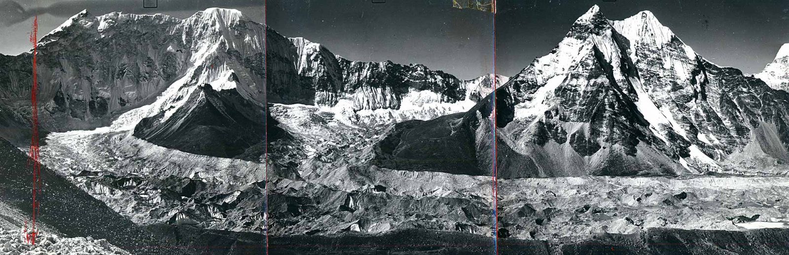
A panoramic photo of Imja Glacier taken in 1955 by Erwin Schneider, Austrian climber and cartographer, offers some of the clearest evidence of climate change impact in the Himalaya. Compared to the image of the same glacier taken by Mountain Geographer Alton Byers in 2015 (below), the photo depicts the drastic degree to which Imja Glacier has melted away. (Photos courtesy of Alton Byers)
(1).jpg)
What was striking to Byers about the image was the glacier itself. When Schneider took the photo in 1956, Imja Glacier dominated the lower half of the frame, stretching east-to-west for some 2,000 meters. Today, the glacier is but a shadow of its former self. In its place, just beyond an active calving face, sprawls a large body of turbid water called Imja Lake. At the time of Schneider’s explorations, less than 65 years ago, this lake did not exist. But rapid warming in recent decades has caused the glacier to melt and recede, feeding water into the ever-expanding lake. At its deepest point of 158 meters (about 518 feet), the lake could submerge nearly all of the Washington Monument.
On seeing this and other evidence of climate change in Schneider’s photos, Byers made it his mission to document the myriad ways warming is altering the landscape of the Everest region. One of his projects aims to recreate the photos taken by Schneider in the 1950s. Each year, Byers follows in the late cartographer’s footsteps, scrambling often onto high, scree-covered slopes, where he captures images that show change over time. These constitute the photographic testimony of the deteriorating Himalayan “cryosphere,” a high land of glacial ice which is under increasing threat of melting away by 2100.
“Global climate change during the twentieth century has had a tremendous impact on the world’s mountain glaciers, particularly in the form of glacial recession and/or disappearance,” Byers wrote in his book, Khumbu Since 1950: Cultural, Landscape, and Climate Change in the Sagarmatha (Mt. Everest) National Park, Khumbu, Nepal. Published in 2017, the book features a collection of repeated photographs that document alterations to the region over the past six decades.
Byers’ book and photo project are but one aspect of a much larger scientific endeavor to understand the impact of global warming in the Everest region. Along with Daene McKinney, University of Texas at Austin Environmental and Water Resources Engineering Professor, and Milan Shrestha, Arizona State University Assistant Research Professor and Senior Sustainability Scientist, Byers is part of a National Science Foundation-funded effort to help local communities adapt to the rapid and in many cases dangerous transformations to their environments.
Nepal’s ‘most dangerous lake?’
I accompanied the interdisciplinary team on two lengthy treks into the Khumbu Valley, in the springs and summers of 2017 and 2018. At issue during the trips was the potential threat posed by Imja Lake, which has been described as “one of the most dangerous glacial lakes in the Himalayas.” As warming accelerated the thawing of Imja Glacier, a natural retaining dam called a terminal moraine has held the meltwater in place, growing a lake that in 2017 contained 88 million cubic meters of water, or the equivalent of 35,200 Olympic-sized swimming pools. The moraine contains this lake at the head of the Khumbu Valley, home to several Sherpa villages and settlements.
The concern, McKinney told me, is that the moraine itself, having developed as a result of the glacier’s outward plowing during the Little Ice Age (1300s-1800s), was never specifically engineered to hold back so much water. Not only that, but the steep slopes of the mountains surrounding the lake actively shed ice and snow in large, powerful avalanches. If one of these were to plunge into the lake, scientists feared it could generate a tidal wave that would race across the surface of the lake, eroding or overtopping the moraine, and spilling a flood into the river valley and communities below. These potential threats left researchers with several ringing questions: What is the likelihood that such an event—known in scientific terms as a glacial lake outburst flood, or GLOF—could occur? And, if a torrent of water went tearing off down the valley, to what extent would it flood downstream settlements?
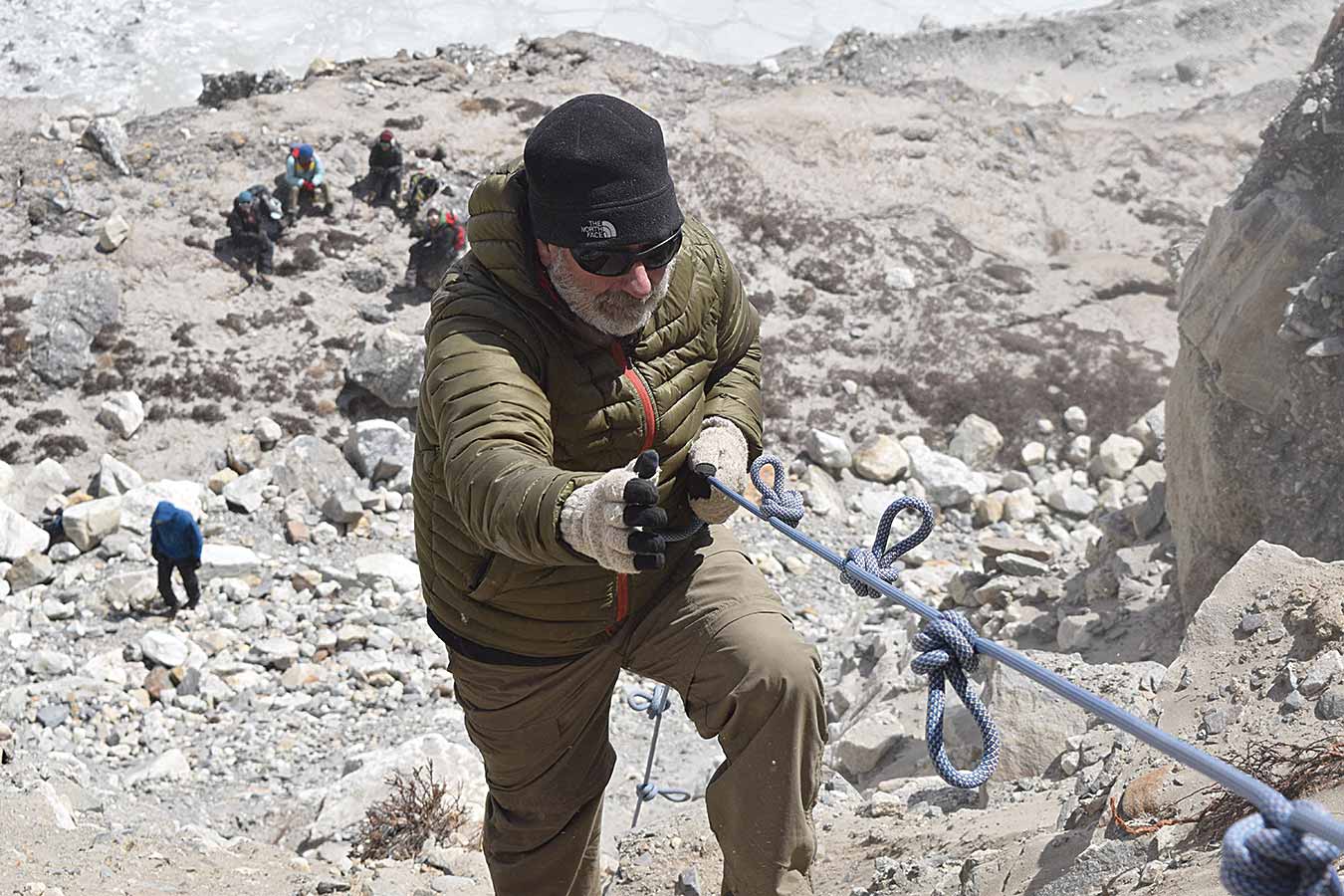
Daene McKinney, University of Texas at Austin Environmental and Water Resources Professor, uses a knotted rope to descend onto the Imja Glacier. (Photo by Chilton Tippin)
As I traveled with McKinney to Imja Glacier—where the 2018 mission was to retrieve a weather station from the debris-covered ice—I learned these questions have been exceedingly difficult to answer. So high are Himalayan glaciers, and so long and difficult the trudge to get up to them, that many lack up-to-date, boots-on-the-ground data as to their evolving dynamics. With respect to Imja, the scientific understanding of the lake’s threat has matured over time. “We’ve done a complete 180 on our thinking about Imja,” McKinney told me, “and that’s a result of this scientific process.”
But I also learned that the difficult answers sought by physical scientists attend a related but separate problem—the challenge of communicating their findings to mountain communities whose ways of thinking are in many respects different than those of scientists or outsiders.
A melting ‘Third Pole’
If communication is a multiway street, Shrestha, the team’s anthropologist, stands at the crossroads of researchers, policy makers, and locals. His project entails not only sharing the findings of researchers with local people, but also gathering data on their perceptions of hazards and sharing those, in turn, with the scientific community. This work is made all the more complex because of the dynamics at play in the Khumbu Valley, one of the most-visited places in Nepal.
More than 45,000 foreign visitors trekked through the Khumbu in the 2016-2017 fiscal year alone. Such an influx of outsiders creates challenges and opportunities, Shrestha said. On the one hand, tourism is the chief economic activity in the area, opening a door for potential communication on the importance of resilience and disaster preparedness. On the other hand, Shrestha said a degree of ‘research fatigue’ has set in with many local people, who have become inured to and suspicious of the influence of so many outsiders. Shrestha’s work has shown that residents of the Khumbu worry not just about GLOFs, but about additional threats to their tourism-based livelihoods. These include earthquakes, avalanches, landslides, and even erratic weather patterns, which disrupt flight schedules and tourist arrivals. “In other words,” Shrestha said, “locals have a more holistic perspective—rather than a sole focus—on glacial floods.”
Communication issues notwithstanding, the melting of the so-called ‘Third Pole’ raises a problem of urgent concern, according to the scientists involved. In many of the world’s highest mountains, from the Andes to the Himalayas, rapid warming is generating a host of dangerous flooding situations. In Nepal, McKinney and his team inventoried 131 glacial lakes of varying degrees of danger. According to Dhananjay Regmi, director of the Kathmandu-based Himalayan Research Center, 29 GLOFS have been recorded in the country. These not only destroyed infrastructure and farmland, but wiped out electricity and killed livestock and humans. In this context, the work undertaken by the NSF-funded team in the Khumbu underscores the challenges scientists face in helping communities adapt to localized impacts of climate change, both in terms of obtaining accurate information to feed into models, as well as in explaining results of those models to local people.
“Glacial lakes are growing very fast, and the threat is increasing day by day,” Regmi said during a June 2018 conference on GLOFs in Kathmandu. “There is a lack of updated information on the present situation. We need to study glacial lakes more to understand the potential hazards we face.”
Imja through time
When I first accompanied McKinney to the Khumbu in the Spring of 2017, he told me that particular trek to Imja would be his last. In seven years, he had made 11 trips to the glacier, which sits at about 5,000 meters (16,400 feet) elevation. In all those visits, he had rambled across its rocky, hummocked surface. He had slept in frigid lodges and fought off altitude headaches and surveyed the glacier’s movements and its depths. He was ready to retire from his tenured position at the University of Texas—did, in fact, retire at the Spring semester’s close.
But in late May of 2018, as we plodded up the steep, interminable hill to the Himalayan settlement of Namche Bazaar, he shook his head and smiled. “I can’t believe I’m doing this again.”
McKinney’s work on Imja began in 2011, a time when concern over the lake’s potential threat was at its highest. Beneath the lake, at the foot of the iconic Ama Dablam peak, sits the village of Dingboche—a bucolic place of tourist lodges, tea houses, rock-built homes and subsistence potato farms. With a population of about 200 people in the low-lying river valley, the settlement seemed to sit smack in the flood path of a potential GLOF. What’s more, the information coming from outside sources—scientists, governmental officials, and the like—conveyed as much to local villagers.
“There was a GLOF hysteria just 10 years ago,” Byers said in the Kathmandu GLOF conference. “Imja was a major source of concern and controversy.”
The atmosphere of fear and uncertainty lingered well into 2015, when the April earthquake and two subsequent aftershocks wracked Nepal. While the country reeled in the quakes’ aftermath, McKinney and Byers launched an expedition into the high country to understand how the tremors had impacted the glacial lakes and villages of the Khumbu and its surrounding region—places which, owing to their remoteness, received little governmental assistance, if any at all.
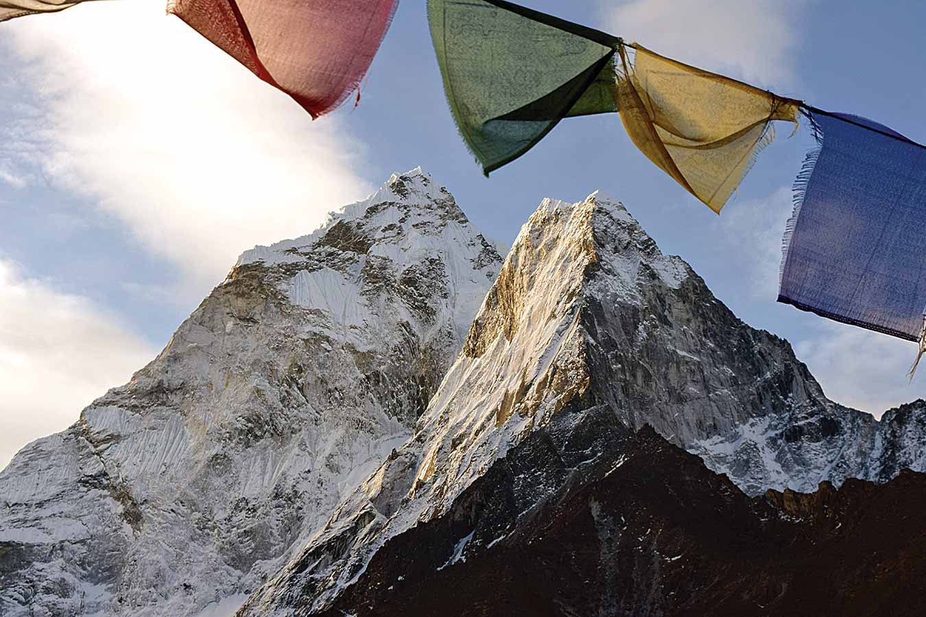
Prayer flags frame the peaks of Ama Dablam, a 6,812-meter high mountain that stands high above Dingboche. (Photo by Chilton Tippin)
The resultant report highlighted the extent to which the Sherpa people feared the precarious lake hanging high above their heads. Just weeks after the earthquakes, in the middle of the night, a flood of water six meters high surged down the valley. Residents from Chuckhung to Lukla grabbed their children and quite literally took to the hills. “Imja is coming,” they reportedly shouted.
But Imja never came. Rather, the flood had originated from within the Lhotse Glacier, adjacent to Imja, when water from a relatively small lake inside the glacier broke free. People in communities below initially assumed this much smaller flood was a rupture of the Imja moraine. This insight, according to the report, underscored the degree to which the lake loomed in people’s imaginations.
Perhaps even more telling, however, was that Imja’s moraine held strong in spite of the powerful earthquakes. This observation, coupled with others made by McKinney and his team, helped usher a change in the way scientists understood the risk posed by the lake. “In the beginning,” McKinney said, “we were going off the work of previous scientific studies. We were very concerned about the moraine—that it might have an ice core which could melt and cause it to collapse.”
But as he and his team began making field studies, they realized the moraine was relatively stable. Ice existed at points within its rocky detritus, but the dam itself was not a steep, thin wall; rather, the moraine comprised a long-and-wide network of ponds, spillways and rock piles, the sum total of which turned out to be quite sturdy.
“The likelihood that some sort of catastrophic failure would eliminate the entire moraine complex is very unlikely,” McKinney said.
He and his team then turned their attention to the lake’s expansion. Each year, the glacier tends to recede about 160 feet on average. As it pulls back toward the cliffs at its head, the danger deepens that avalanches might tumble off the mountainside, crash into the lake, and send forth a tidal wave that destroys or overtops the moraine.
McKinney’s team modeled the future melting of the glacier until the year 2045. They also forecast potential waves generated in the event of such an avalanche entering the lake, paying particular attention to flash flooding in Dingboche.
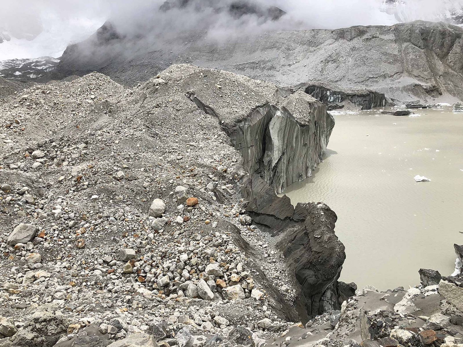
The Imja Glacier's calving face recedes each year into a growing lake, which contained some 88 million cubic meters of water in 2017. (Photo by Chilton Tippin)
During a June 2018 community meeting, McKinney reported the team’s findings to a small group of residents assembled in a town lodge: “If this happens, it will not be a big flood,” he said, “but a smaller flood, and it will stay in the river channel, without danger to farmland and buildings here in Dingboche.”
If these results weren’t enough to assuage concerns, the Nepali government also undertook a project in 2016 to lower the lake and install an early-warning system that would alert downstream residents if a GLOF overhead were to occur. These measures and the studies’ results lead to a rating of Imja by McKinney and David Rounce, then one of McKinney’s Ph.D. students, as “moderate” on the risk scale—a far cry from the early “doom-and-gloom” prognostications. “The evolution of our thinking is that the risk is low—at least until 2045,” McKinney said. “And this, quite frankly, is good news.”
McKinney hoped the positive results would spell relief for locals. Instead, he discovered that in some villages the findings were met “with a shrug.” Meanwhile, administrators in Kathmandu have struggled to find resources to adopt recommendations—especially those regarding the rankings of dangerous glacial lakes—into their policy plans.
“I’m a civil engineer,” he told me, “and that’s how I look at these problems. We don’t tell governments what policies to enact. We make recommendations based on the best science available.”
But he’ll also admit that problems in Nepal tend to transcend the calculated findings of engineering studies. Difficult as the results were to obtain, they’ve become entangled in a web of cultural perceptions.
Sharing findings
Over the years, McKinney, Byers and Shrestha made consistent efforts to collaborate with local residents. Dating back to the start of their project in the Khumbu, the researchers worked alongside communities to develop a Local Adaptation Plan of Action, or LAPA. Funded by the U.S. Agency for International Development (USAID), the LAPA was designed specifically to help Khumbu settlements cope with climate-driven impacts. The plan prioritized local development needs and made the sharing of results routine. At its heart, the plan was meant to integrate scientific knowledge into the communities’ understandings of climate vulnerability, thus allowing local residents to make decisions in light of the most up-to-date information available. The researchers have returned each year to do just that.
And yet, challenges remained. For one, with so much international interest in the Everest region—from scientists to trekkers to the annual onslaught of climbers attempting Everest—the people of the valley have conflated foreign researchers, tourists, and even officials from Kathmandu into the catch-all category of “outsider,” Shrestha explained. And this “outsider” label comes with a healthy dose of skepticism.
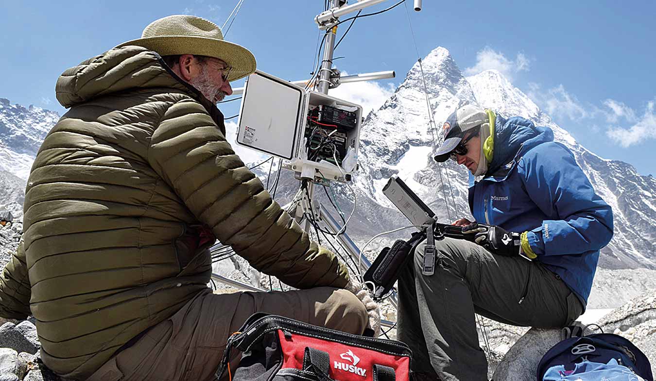
Daene McKinney, University of Texas at Austin Environmental and Water Resources Engineering Professor, and David Rounce, Research Associate at the University of Alaska, Fairbanks, download data from a meteorological station on the Khumbu Glacier. (Photo by Chilton Tippin)
“The Khumbu region has a long history of contesting the top-down control from the central government,” he said. “They have always taken the messages and messengers with skepticism. So, when we are relaying this message of the GLOF, they have a good reason to be skeptical, because, as I said, there’s a fatigue going on.”
And while uneasiness among residents of glacial floods is real, the Sherpa people remain “wary of overdramatizing the fear,” Shrestha explained. Tourism is the valley’s economic bread and butter. They don’t want people to think the Khumbu is unsafe to visit.
Finally, Shrestha pointed out that the researchers are contending with general confusion, in part because the science explaining Imja’s situation took such a long time to unfold. As McKinney explained, it wasn’t until his team had taken soil samples, gathered numerous flow readings, conducted bathymetric surveys, analyzed satellite images, installed weather stations, forecasted the growth of the lake, determined the likelihood of avalanches, and modeled the potential force and intensity of surface waves, among other measurements—all of which were undertaken over the course of numerous visits to Imja—that they were able to come back with confident results. And those results, though positive, differed from previous information that had been shared.
“In science, it’s OK to have that level of uncertainty,” Shrestha said. “But in communities, when there’s uncertainty, particularly for policy makers, those uncertainties count.”
The god in the lake
Shrestha’s part in the project aims at smoothing out such communication wrinkles. He shares scientific results with locals. He also rolls up findings from his anthropological studies to scientists.
During the course of numerous interviews and nearly 140 household surveys, he and his students have unearthed interesting information on residents’ perceptions of natural hazards. In 2017, for example, GLOFs remained a concern in the valley, ranking as number two behind earthquakes. But responses to the actual danger of GLOFs are enmeshed in the social meanings people give to the landscape, which are themselves imbued with religious significance.
Devout Tibetan Buddhists, for example, engender certain rocks, lakes, mountains and rivers with deified personalities. In the belief system of some Khumbu residents, many lakes—Imja among them—are home to a god called Lü or NaÂga. Disturbing NaÂga, which takes the form of a water serpent, by polluting or lowering the lake could incur the god’s wrath, Shrestha explained. A disruption might even prompt the Lü to seek revenge by causing a flood.
“We had a very complex and nuanced understanding of what is considered natural and supernatural,” Shrestha explained during the GLOF conference in Kathmandu. “For example, if they can control something, like a landslide, then they do prepare for it.”
But if residents feel a natural phenomenon is beyond their control, “if it’s something that they cannot even fathom, then that (phenomenon) is supernatural, and they have to go back to the Lama and seek an explanation—‘what action should they take?’”
For many residents, large environmental catastrophes, such as GLOFs and earthquakes, are assigned to the category of “supernatural,” he said. Considered as such, these disasters demand spiritual deference; in the minds of the people, “the best thing to do is to find refuge in faith and religion, and to try to seek information from that.”
For these reasons, communicating findings in the Khumbu is like threading a needle. Researchers strove to respect cultural and religious significances. For example, they conferred regularly with religious leaders, visiting their monasteries, schools, and homes. Even so, the situation at Imja demanded a comprehensive scientific interrogation. In the Imja case, the physical science ultimately revealed heartening results, at least until 2045. But the same is unlikely to be true for all the lakes rapidly growing above high-mountain communities—both in Nepal and elsewhere.
Future glacier loss—best and worst scenarios
When I spoke on the phone with McKinney’s former Ph.D. student, David Rounce, now a research associate at the University of Alaska, Fairbanks, he put the wider issue of GLOFS and melting mountain glaciers into perspective. His most recent work projects glacial mass change in high-mountain Asia through 2100, building on models put forth by several scientists who project glacier-mass loss based on potential future scenarios called Representative Concentration Pathways, or RCPs.
RCPs, Rounce explained, largely depend on “radiative forcing,” a measure that takes the balance between the amount of solar energy reaching the Earth’s surface, versus the amount reflecting back into space. “Forcings” refer to anything entering into the atmosphere’s composition that forces it to absorb more energy, thus causing the earth to draw in more heat.
“It’s really trying to understand different scenarios of climate change,” Rounce said of the research.
The most optimistic scenario is RCP 2.6, he said, whereas RCP 8.5 is the most dire. Between those, studies have found that anywhere between 50 to 90 percent of glacier volume in high-mountain Asia would be lost by the end of the century.
Rounce went on to explain that these numbers hinge in large part on humankind’s ability to check greenhouse gas emissions. If, for example, the Paris Agreement of 2015 were adhered to, if we were to limit warming to just two degrees Fahrenheit over the century, then we would likely see more optimistic values—closer to 50 percent of glacier mass loss in high-mountain Asia.
“If climate change continues and it remains unchecked,” Rounce pointed out, “then you might have more of those worst-case scenarios occurring.” In other words, closer to 90 percent glacier-mass loss.
The studies are based on the best knowledge available, but Rounce cautioned that the scientific understanding is still under development, and therefore imperfect. His work using remote sensing hopes to help refine scientists’ findings, bringing a more complete picture into focus.
I asked him how this increase in melting mountain ice might impact the frequency and intensity of GLOFS. His reply: “Difficult to say.”
“It’s certainly true that as the glaciers are retreating, glacial lakes are forming, and they become more susceptible to having avalanches or landslides entering,” he said.
For that reason, it’s “more than likely” that the number of GLOFS is likely to increase. But it’s hard to forecast when such an uptick in GLOFs might occur.
Simple, adaptive technologies
Back in the Khumbu, despite all the challenges, Byers, McKinney, and Shrestha maintain there are reasons to suggest people are hearing the warnings of scientists, observing the changes in the world around them, and responding.
Byers has spent some 40 years working in Nepal’s Himalaya. At various times, he has witnessed firsthand the Nepali people’s resilience—and their ability to adapt.
In 2004, he and his wife, Elizabeth Byers, a botanist and wetlands scientist, began drawing attention to the denuding of hillsides in the subalpine region of the upper Khumbu Valley. Their research revealed the ubiquitous shrub juniper—a low-growing bush instrumental in providing habitat and defending against soil erosion—was being removed by local residents.
Juniper, Byers explained, made for a useful fuel to burn for warmth in people’s homes and lodges. Thousands of kilograms of the slow-growing wood were also burned during Everest climbing pujas at base camp, ceremonies meant to secure safety for ascending mountaineers.
With increasing tourism—more climbers and more people in lodges—juniper was being harvested at unsustainable rates, accelerating soil erosion from the region’s hillslopes. But the Byers’ research and work in the field helped spur a local community organization to band together. Called the Khumbu Alpine Conservation Committee, the organizers campaigned for alternative forms of fuel, such as imported kerosene. To Byers’ surprise, they even put an end to the burning of juniper for pujas at Everest Base Camp.
As a result, shrub juniper regained a foothold in the alpine zone of the upper Imja river valley, including those slopes surrounding Imja lake. Today, Byers said, the fragile and slow-growing shrub has made a strong comeback in the Khumbu and elsewhere, in turn restoring the “geomorphic glue” to the previously stripped hillsides.
Likewise, he has noted evidence of a local response to the threat of GLOFS and glacier floods. In the highest settlement in the Khumbu Valley, a place called Chukhung, rock-filled cages called gabions were built along flood zones following a 2015 flood from the Lhotse Glacier. In 2016, the same glacier flooded again. This time, gabions diverted the flood from destroying the village.
“(Gabions) are very simple and very effective technology,” Byers said. “I don’t remember seeing that many gabions in the mountains of Nepal 10 years ago. But everywhere I go now, they seem to be constructing these.”
He takes these adaptive measures as examples of how “simple technology” can help “save the day.”
On the whole, Byers explained, “Nepal has clearly entered a new era of accelerated glacier hazards.” Yet this need not spark overwrought reactions and needless fear. “There have always been these types of events,” he said. “There always will be these types of events.”
To his mind, the physical science and social science should walk hand-in-hand. Research offers an important tool in understanding the complexity of hazards. “Meanwhile,” Byers said, “the local government and people are finding ways to deal with them.”