The far western hills of Nepal were popular once as the birthplace of the Maoist revolution. Today they make up a new, intriguing trekking trail that weaves around the landmark events of that era.
A deathly internecine war imploded in a land where a common first name is Love (Prem and Maya), or a variation such as Flower Love (Phulmaya) and Heart Love (Dilmaya). The term Maoist still elicits a visceral, negative reaction in most people and the rebels earned a reputation for ferocity during a decade long campaign that took upwards of 15,000 lives. But most of the rebels are radically typical Nepali hills people, as pleasant as anyone across rural Nepal, a country legendary for hospitality.
 The Guerrilla Trek offers a remarkable journey through the heartland of post-conflict territory. The route passes through Myagdi, Rukum, and Rolpa, spectacular districts with low population density at the epicenter of Nepal’s ten year conflict (1996 to 2006), and homeland to many revolutionaries. As the former stronghold of Maoist activity, the region even had an autonomous government in Banphikot, Rukum.
Away from mass tourism trekking highways, the Guerilla Trek provides a chance to meet people of Nepal largely unaffected by commercialization and regulation of the travel industry. Many ethnicities enrich the route including Bahun, Chhetri, Dalit, Gurung, Magar, Newar and Thakuri people. The Kham-speaking Magar culture is unique to northern Rolpa and eastern Rukum. These Magar have distinguishing customs and a distinct language of the Tibeto-Burman family.
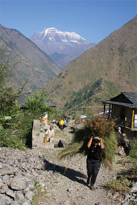
 The trek begins in Beni (2705 ft, 823 m), a four to five hour bus ride from Pokhara. The sprawling town lies in Dhaulagiri Zone at the confluence of the mighty Kali Gandaki River and the Myagdi Khola and is the District Center of Myagdi. Beni is a hub for trans-Himalayan trade and for travelers heading northward along the western half of the Annapurna Circuit. Transportation heading north can be arranged to Jomsom, Kagbeni and Muktinath, an ancient pilgrimage site mentioned in the Hindu epic saga, the Mahabharata.
Beni was selected for attack by the Maoists on March 20, 2004. Nearly 6,000 Maoists (3,000 soldiers and equal number of support staff) descended on the town under cover of darkness. The attackers and the police suffered extensive casualties and injuries. The district headquarters building was razed in the process and a statue of King Mahendra was toppled and demolished. Capturing a major district center close to the city of Pokhara was a momentous achievement for the Maoists that jolted the nation. Most of the guerrillas gathered in Dhorpatan and came to Beni for this raid along the eastern portion of the Guerrilla Trek.
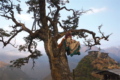
 The trail from Beni soon passes the soothing hot springs at Tatopani. Many people believe that the spring waters are curative and domestic tourists come from afar to spend days here. Ascend through timeless, pastoral villages on the way to the remote highland meadows of Jaljala (11, 200 ft, 3414 m). The expansive views here of the Dhaulagiri Massif are jaw-dropping. Herders occupy this high, broad pastureland during the rainy months and a seasonal tea shop might be in operation, too.
The trail gradually descends and follows the Uttar Ganga River to Dhorpatan through a magnificent valley that is extravagantly covered in flowers during summer and post monsoon. Approaching Dhorpatan, the trail passes a Sowa Rigpa (Tibetan medicine) seminary where apprentices learn the art of finding and harvesting plants, preparing compounds, as well as diagnosing patients, and dispensing remedies, mostly herbals (jadibuti) from the nearby high hills. Visitors can have a consultation with an amchi (healer) for a token fee and involves manually measuring one’s wrist pulse, checking the coloring in the whites of the eyes as well as tongue. Herbal remedies are meted out for a nominal price from their in-house dispensary.
 At the Dhorpatan Hunting Reserve headquarters, entry permits (3000 NRS) are checked. From 2001 to 2004, this bureau was closed due to the conflict. Upwards of 80,000 livestock are brought to Dhorpatan (9415 ft, 2870 m) from surrounding lower elevations from March to October. About two dozen foreign hunters pass through every year, mostly looking for blue sheep rams and tahr, a goat-like mammal. Barking deer, wild boar, and pheasant are also pursued. Hunters, conspicuous by large camps with a coterie of aides, pay 25,000 rupees for a general license and are charged 40,000 rupees for each blue sheep killed and 20,000 rupees per tahr. From autumn of 2010 to spring of 2011, 22 blue sheep and 8 tahr were taken. The reserve is jointly located in Myagdi, Baglung and Rukum districts and hunters pay enormous supplemental fees to the district government where the animal is slain: 150,000 rupees for a blue sheep and 100,000for a tahr. The office employs 32 staff including additional outposts, although rarely manned, at Maikot, Taka, Gurjaghat, Gurjakhant and Niseldhor. Other than hunters, around 50 to 70 trekkers have been trickling through each year, mostly on the way into or out of Dolpo. After the Maoist raid on Beni, the army pursued the guerrillas and blocked retreat at Niseldhor, a day’s walk to the west and many guerrillas fled north to Maikot from this point.
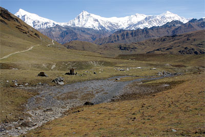
The three routes that make up the Guerrilla Trek diverge at Dhorpatan. The longer routes head north while the shortest route continues west along the Uttar Ganga to Taka and Sera villages. The Uttar Ganga River emerges as a runoff from the southern slopes of Dhaulagiri (8,167 m, 26,749 ft), the world’s seventh highest peak, and its broad range. It drains the Dhorpatan Valley and is a tributary of Rukum’s Sani Bheri River which becomes the Bheri River, itself a branch of the great Karnali River whose waters eventually flow into the mighty mother Ganga (Ganges) of India. The sacred Ganga flows across the plains of north India and empties into the Bay of Bengal near Kolkata (and eventually the cycle is completed as moisture from the Bay of Bengal is brought back to Nepal by monsoon rains).
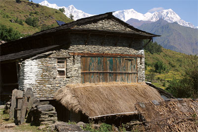
 The romantic villages of Taka, Sera and Bacchigaon are populated mainly by Magar, Dalitand Gurung and have many medieval passageways between dwellings and shared rooftop courtyards and the surrounding area leaves a lot to be explored. Magar here have a unique way of life and housing. As the prevailing culture in eastern Rukum and northern Rolpa, their lifestyle remains largely undiluted and even other ethnicities in this area have learned the distinctive Kham-Magar language. Magar people in other regions have become assimilated to different customs whereas these areas remain authentic.
Homes typically have flat-roofs which serve as daily venues for gathering socially as well as drying and storing harvest bounty. The Mayur (Peacock) Dance is common in locally celebrated festivals. Groups of costumed dancers perform together to music. Apparel includes silver, copper, and peacock as well as pheasant feathers. The Bhume Naach, is a Magar dance performed to honor the land, signifying gratefulness for harvest blessings with participation by whole villages. The Bhume festival falls in the first week of the Nepali month of Asar (around mid-June) and lasts nearly a week. Preparations begin a fortnight ahead with young people often seen practicing for accompanying dances in the evening time. “Bhume” is derived from the word “bhumi” which means earth. Magar here traditionally worship nature and their ancestors rather than deities.
Also known as Bal Puja, the festival occurs before the monsoon and presages protection from the wrath of nature (example, drought, hailstorms, landslides, flooding, high winds) and entreats a bountiful harvest. Sometimes animals are sacrificed to appease higher powers in hopeful exchange for the human lives that would be lost due to natural calamities and ill-health. Villagers celebrate the festival by assembling in ceremonial areas to dance, sing and socialize. Special dances known as jhimkari and balku shyne occur only during this time.
The Taka area hosted a foreign missionary and his family in in the mid-1980’s for more than ten years until the beginning of the conflict. He learned Kham Magar language proficiently enough to translate a Bible into it, and built a church in Taka as well as a hydroelectricity plant. The village has about 400 households and 5-10% are Christian whereas about 25% of Bacchigaon is Christian. Taka’s church is the room above the hydropower plant with a flour mill at the lower end of town. Upallo Sera, was the site of a major encounter between guerrillas and police forces in April 2000. Two police offices were destroyed in the raid and munitions were captured. The police and the guerrillas both suffered casualties.
The northern routes re-unite with the lower route in Taka and Sera. Additional attractions along The Guerrilla Trek include hot springs pools for relaxing and rejuvenating between Thulo Jarlung and Pelma villages. The concrete pools were built in 2009 by a local youth club. Another highlight is the spectacularly set Maikot (7545 ft, 2300 m) perched on a ridge top. The name, according to Binod Kumar Pariyar, a former guerrilla, is derived from a legendary triumph long ago at this hamlet. The ridge top was besieged by intruders and inhabitants fended off the attack. The settlement’s name was thence derived from words meaning ‘Victorious Fortress’. The village is bounded by fertile fields and has an impressive view of the surrounding territory. A newly constructed, large hospital is situated above town.
 In late September of 2000, the guerrillas accomplished an astonishing raid from Maikot on Dunai, the headquarters of Dolpo District to the north. Their original route was exposed as it passed Pupal’s craggy highlands, where Yarsagumba is collected in May. Intelligence of their initial movement was leaked and the rebels retreated to Maikot, but resumed again a few days later, this time using a relatively unknown route further west. Again, information was leaked but they nevertheless carried forward, overwhelming the waiting police forces and ransacking the district headquarters building, bank, prison, police post and weapons cache before returning to Rukum.
The towering mountains and hill scenery are an omnipresent highlight of these trails as they are for much of the trails in Nepal. The centerpiece of the region is a solitary Sisne Peak (5849 m), vibrantly rising above the hills and valleys. Sisne shares a remarkable resemblance to the sacred Machhapuchhre (Fishtail Peak). Ascents of neither the snowy summitof Sisne nor Macchapuchhre have been recorded and therefore, both are referred to as ‘virgin peaks’. Perhaps it won’t be long until Rukum climber Manbahadur KC from Banphikot, stands upon its summit. In May of 2012 he scaled Everest, becoming the first person from Rukum to achieve this feat, bringing mountaineering glory to the district.
Another attraction from the time of the warfareis a ridge top location named Melgairi. Here the Maoists broadcast a radio station named Ganatantra (“Republic”). The area was kept secure by a line of combatants that was continually on watch and transmission equipment was mobile, allowing swifttransportation using a Doko (woven basket) and tumpline, the usual way to transport goods in the hills.
The idyllic Syarpu Lake (4280 ft, 1305 m) is a pleasant place to relax and savor the divine setting. The surrounding area is dominated by Thakuri people, formerly known as a ‘warrior caste’ which includes the erstwhile royal family. A viewpoint tower is perched above the east side of the lake while a community lodge to the west is run by a former Kolkata (Calcutta) restaurant manager –
you can expect good food and service!
The hamlet of Radhijhula (2970 ft, 905 m) lying on the Jajarkot border is a peaceful retreat. The settlement is a gateway to Dolpo along a main supply route to Dunai and Jufal and many traders come here to buy and sell goods. The serene and charming community features prominently in war history for not-so-serene reasons. On February 13th, 1996, it was one of three police outposts as well as a bank in Gorkha pinpointed for the initial raids that commenced the “People’s War”.
The other police posts were in Rolpa and Sindhuli districts. These positions were chosen for vulnerability and seen as easy targets. According to Ram Sur Budha, aka “Birata”, one of the guerrillas at the scene, 39 Maoists led by Ganesh Man Pun advanced on the police post at Radhijhula with two 12-bore guns, axes and explosives. They approached at midnight with five groups: assault, reserve, capture and defense and a group to blockade the area from outsiders. Although well-prepared, it was a peaceful foray as the constables were caught unaware, literally sleeping, and easily apprehended without a fight or casualty. They were given the message to relay to the central government that the “Peoples War” had begun. Pun’s wife, Kamala Rokha was a commander during the conflict and subsequently become a minister in the Baburam Bhattari led government and is featured in the documentary, The Sari Soldiers (2008) by Julie Bridgham.
Another serene highlight on the trek is Rukumkot (4970 ft, 1515 m), known as “the land of 52 lakes and 53 hills” for its luxuriant surroundings. Médecins Sans Frontières (aka, Doctors Without Borders) operated a hospital here for three years during the war as well as in Rukum’s district headquarters of Khalanga for five years during the war and for half a year in Radhijhula. Rukumkot’s attractiveness is enhanced by Kamal Daha or Lotus Lake (also known as Rukmini Tal), and if you are lucky enough to visit in the summer season, the waters will be filled with lotus blossoms. Barahi Temple is just offshore and nearby is Sibalaya Temple and the famous Deurali Cave is in the area, too, near the tributary river known as Rukumgad.
The ridge above the lake was the scene of a major clash in April, 2001 and a milestone rout for the Maoists. Police had established a camp along the ridge line and the Maoists attacked under cover of darkness and captured 38 police who were sent marching. The police and Maoists again suffered extensive casualties. The Maoists had a temporary medical camp below and many rebels left for Chunbang soon after the hour-long skirmish. The area of Chunbang, specfically Bheridanda, is a well-known historical meeting point where Maoist leadership gathered in 2005 to discuss uniting with a seven-party coalition and set details for ending the armed struggle. Despite objections by some factions, the inter-party alliance they joined was considered necessary in order to abolish the monarchy.
Another highlight is the area of Lukum (6875 ft, 2095 m), largely Magar and Kami with a prominent grove of soaring Juniper in the area. The French anthropologist Anne de Sales lived in Lukum for several years and has written extensively on the Kham-speaking Magar people and their unique culture and traditions. Lukum is also well-known for Shamanism and hosts a large, lively gathering of Shamans between July and August with ritual singing, chanting,drumming and dancing.
War-wise, Thawang (6480 ft, 1975 m)
has a violent history; it is one of the oldest communist centers in western Nepal and experienced some of the heaviest fighting during the war when army helicopters frequently arrived in waves. Many dwellings were burned to the ground and destroyed at that time, and recently, the settlement has seen many improvements and the lanes of this village are uncommonly wide. The village is made up chiefly of Dalit and Magar and a giant, black and white mural greets you at the entrance with depictions of Marx, Engels, Lenin, Stalin and Mao. A road dubbed Shahid Marg, or “Martyr’s Way” is under construction from Holeri in Dang District to Thawang.
An interesting and somewhat unsual highlight in the trek are the Ajambari Jana and Balidan Communes. Left-leaning trekkers might be particularly interested to visit the first of a few functional communes in Nepal. The residents aim to live a shared lifestyle, and meals are taken together in a collective dining area.
Rolpa’s Jaljala (10140 ft, 3090 m), is an open grassland, seasonally inhabited by herders. There are many shepherd huts and two small, rock built temples as well as a stone-walled, central pond. Ascend any of the smaller hills to improve views of the snowbound Himalayan peaks. The area and environs was a former highland training ground for guerrillas and now has a multi-storied temple, Bujuthan, with three water taps and nearby is Bhangma Pup (“Torch Cave”) a large cavern that also serves as a shrine. Dharampani, the name of a ridge top (11,572 ft, 3527 m) to the southwest, has a Maoist memorial.
Cultural dances are sometimes encountered on the trail, unique for an outsider but common to the communities and traditions in the area. The Singaru Dance is popular in western Rukum and adjoining districts, where men dressed as women dance to folk songs about courtship and love accompanied by music. Traditionally, it was considered taboo for women to dance in this manner and therefore men have taken on the feminine role. The Sorathi Dance is similar and enacts episodes from Hindu deity Krishna’s life. Dancers often go into a trance to the beat of the music and some begin convulsing. It is believed that a great spirit enters their bodies during the process. Many Nepalis share a strong belief in shamans, especially for healing ailments, consecrating homes and events and augmenting good fortune.
Religious practices in the hills include Hinduism and Buddhism as well as animism and ancestral devotion as well. Regardless of belief, people join together for the lively activities that accompany festival celebrations.
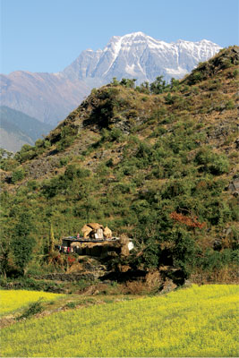
Agriculture along the route includes rice cultivation up to the mid-hills. The surrounding terraced fields paint the hills green during the summer growing season. Rice is usually sown in Nepal in the early summer, just prior to the monsoon season. Harvest occurs in October around the time of Nepal’s most significant festival of Dashain, a ten-day event celebrated nationwide. Dashain is a time for family reunions and a tribute to the triumph of good over evil. At these times, people come together to sing and dance with traditional music of drums, horns, flutes and cymbals. Performers often wear customary outfits and roam from home to home as a merry crowd around them swells. Onlookers are often invited to participate in the revelry.
Barley, maize, millet, wheat, andpotatoes as well as apples and apricots are cultivated in the upper hills. There are many splendid high elevation meadows and valleys used for monsoon pastureland of cattle and buffalo, and foraging for Yarsagumba (believed to be an aphrodisiac) in the rugged highlands has become an important source of income, revenue from its harvest also helped fund Nepal’s Maoist insurgency. Yarsagumba is the larva of the Himalayan ghost moth (Thitarodes) that is transformed by the fungus Ohiocordyseps Sinensis. It is believed to enhance energy, male virility and general health but these putative properties await conclusive research. The desiccated caterpillar husk is generally pulverized and added to food or boiled in tea, and sometimes plopped whole in soup.
Journey to Yarsa (2011), a documentary by Dipendra Bhandari of a Yarsagumba caravan in Rukum captures a lifestyle that has developed around the Yarsagumba phenomenon. It “simultaneously reveals the struggle, hope, laughter, romance and resilience in the lives of the hill people who go to dig for survival in the High Himal.”
Why do the Guerrilla Trek ?
It was on the trails of The Guerrilla Trek that the revolution was planned, ignited and launched, eventually toppling the 239-year old crown and achieving a popularly elected Maoist-led-government. The route passes many historical sites, some were scenes of major clashes. It is now an area of immense peace, beauty and hospitality that is open, ready and willing to host tourists. By choosing to travel in this area you will not only be spreading tourism wealth to lower income people but also traveling in a secluded, majestic, yet heretofore overlooked region.
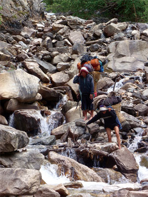
This trek is for unique tourists seeking an experience that could long ago be had on the well-established routes. As an alternative to these popular areas, the entire trek will be a pleasure to return visitors and all Nepal lovers. The trails reach isolated areas far from modern amenities and facilities. Although some tourist lodges are available, if not camping, staying in simple lodges or people’s homes will be necessary most of the way. Not only is the area remote, some days between facilities, for those not camping, are long and strenuous and the journey requires both physical and mental fitness and stamina. That said, the rewards are substantial for trekkers setting out on this route. The area offers an unforgettable experience of mid-hills culture, an age-old way of life, and local dishes and drinks in a land of luxuriant beauty.
Escape Kathmandu’s political quibblers and seek higher ground. The a rmed conflict is long over and locals, former guerrillas and police in Rukum and Rolpa, the ones in the thick of the combat, will welcome you. They bore the brunt of the pain, and if they can get along now, why should others still hold a grudge? The people along these trails are clear evidence that Nepal’s hills are now an abiding place of peace. You are invited to experience the land and its inhabitants for yourself.
Advisory: Do not trek alone, especially on lesser-used routes, and especially as a female (unfortunately, double standards exist). Find a trustworthy travel companion. Those traveling alone should hire a guide or a porter, especially on trails with few tourists. One of the members of the Trekking Agencies Association of Nepal (TAAN) can assist in arranging the details.