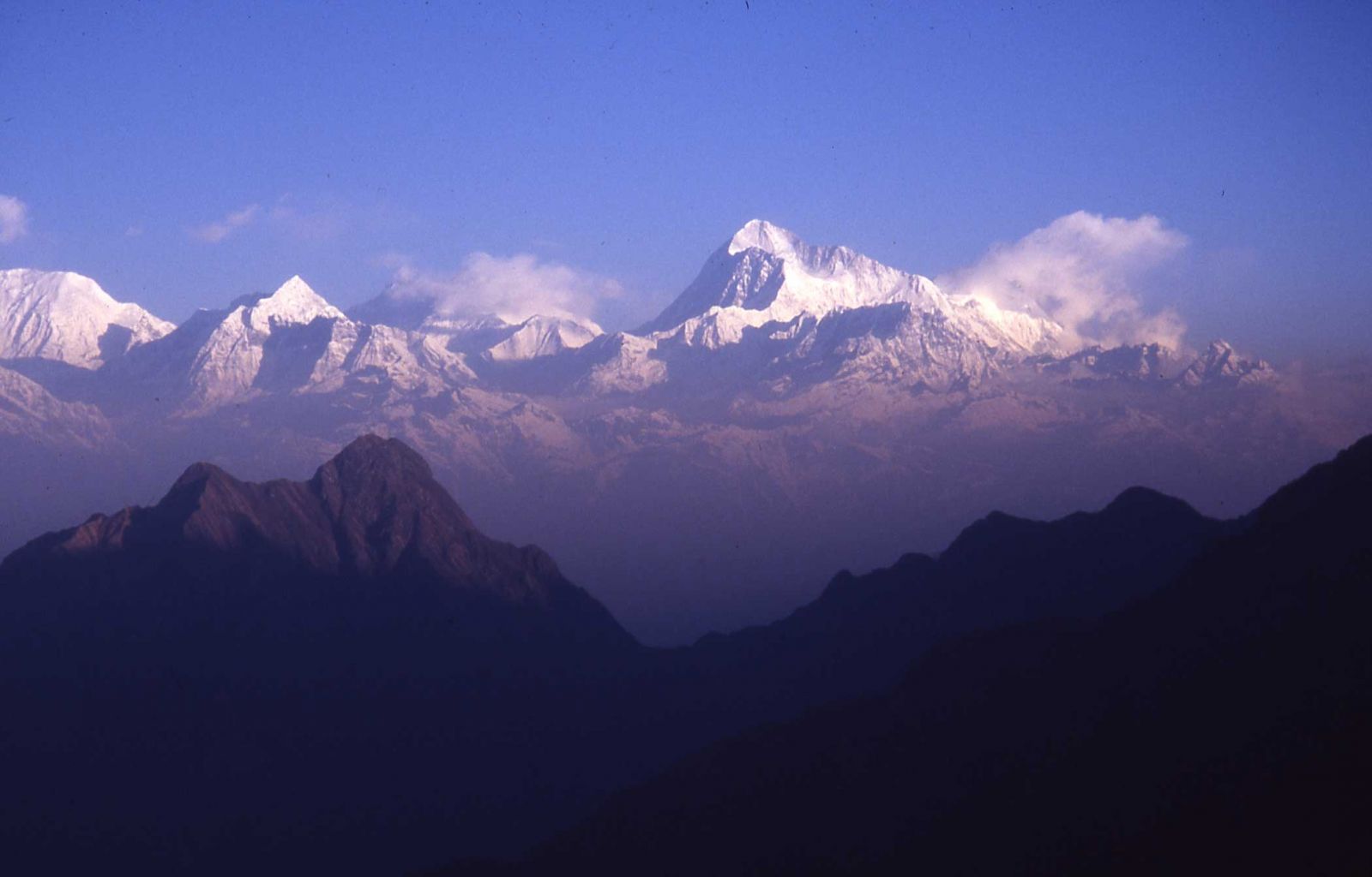
Makalu (8485 m), the world’s fifth highest mountain (photograph by A. Byers).
In late September 1972, some 300 porters shouldered their 80-pound (36 kg) loads in the dusty eastern Nepali town of Dharan, in the lowland plain below the Siwalik Range, and started climbing uphill on a two-week trek toward one of the highest peaks in the mighty Himalayas. Looming on the Tibetan border over 120 miles away was the majestic Mt. Makalu, at 27,838 feet (8,485 m) (Figure 1)the world’s fifth highest mountain. But this was not a mountaineering expedition; instead it was more reminiscent of the early nineteenth century natural history explorations of the Indian sub-continent, except with a more modern approach.
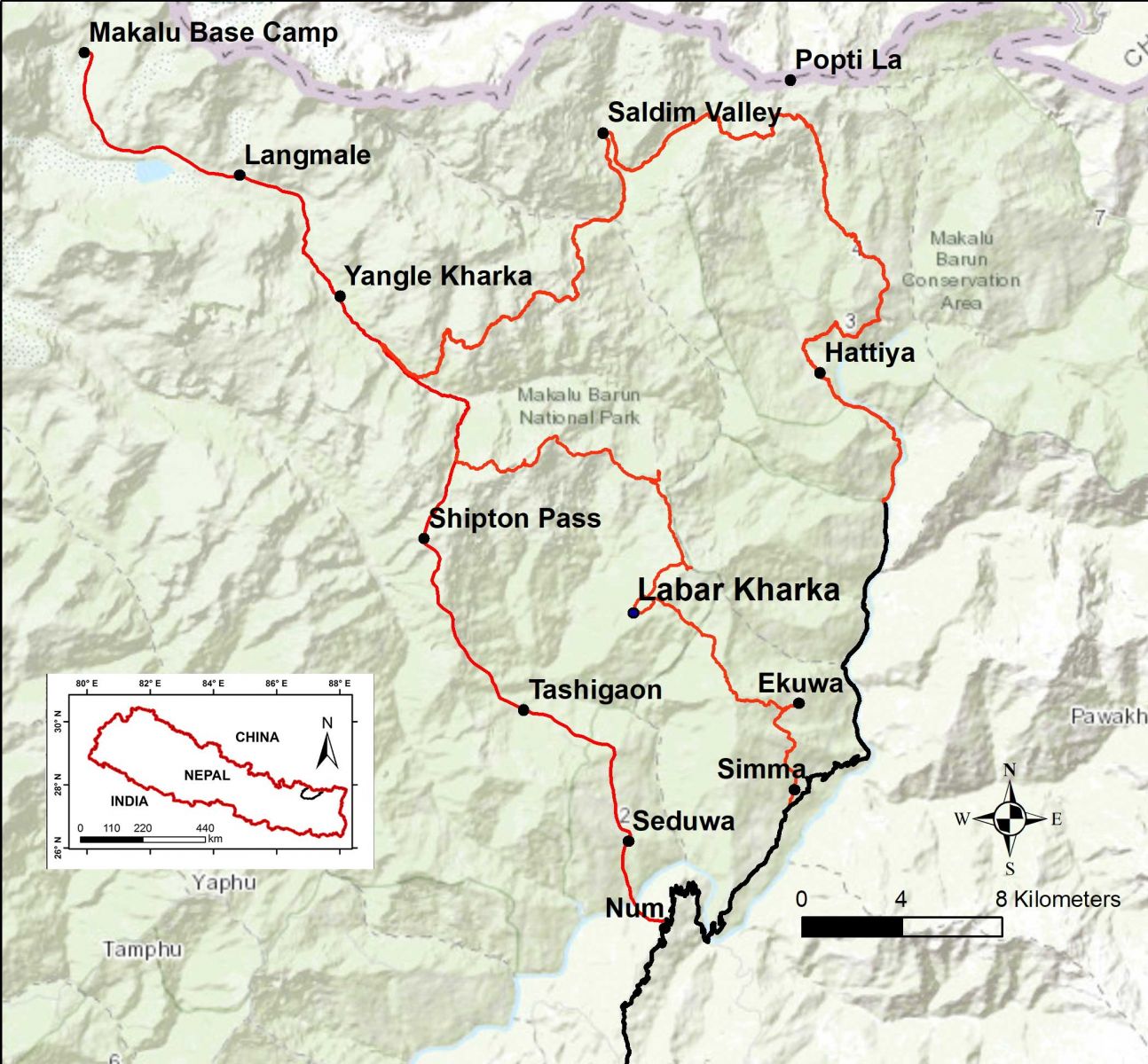
Makalu-Barun National Park and Buffer Zone, east Nepal
Called the “Arun Valley Wildlife Expedition” (AVWE), this was an interdisciplinary exploration and documentation of the wildlife of the little-known upper Arun River Valley (Figure 2). The co-leaders were two young Americans, Ted Cronin [1] (whose main interests was birds) and Jeff McNeely [2] (working mainly on mammals) who had spent the previous two years as Peace Corps Volunteers with the eminent Thai conservationist Dr. Boonsong Lekagul. They were joined by Dr. Howard Emery (a physician whose main interest was external parasites) and Dr. James Foster (a botanist from Harvard University) for an enterprise that would last until December 1973. A dozen other scientists contributed for shorter periods during the expedition, documenting reptiles, amphibians, egg whites, genetics, and other specialized disciplines designed to help tell the dramatic story of the plants and animals of one of the last remaining great wildernesses of the Himalayas
For two weeks the expedition broadly followed the Arun, the only river that arises in Tibet and slices through the Nepal portion of the Himalayas, slowly marching at a porter’s pace up and down the east- west chains of the lower Himalayas and crossing the churning Arun on a woven vine suspension bridge over 200 feet long (Figures 3 and 4). They finally reached a clearing at about 9,000 feet (2,743 m) in the magnolia-birch-rhododendron forest well
aboveLumdumsa, the highest village in the Kasua stream drainage, with Mt. Makalu looming above. Named Labar by the local Sherpa people (pronounced “Laabar”), the clearing (locally called a kharka) was used for grazing livestock on their way to the higher pastures during the rainy season (May-September). The porters dumped their loads, collected their one dollar a day earnings, and headed happily back home down the trail, leaving behind the scientists and 30 or so Nepalese field staff, from Sherpa, Rai, Gurung, and other ethnic groups. The expedition considered this to be the “…perfect site, close to a variety of habitats centrally located in the upper Arun Valley, and less than seven days walk from the airstrip at Tumlingtar” [3] (a grass-covered plateau above the Arun River that was large enough for a STOL aircraft, providing the best way to keep in touch with the rest of the world).
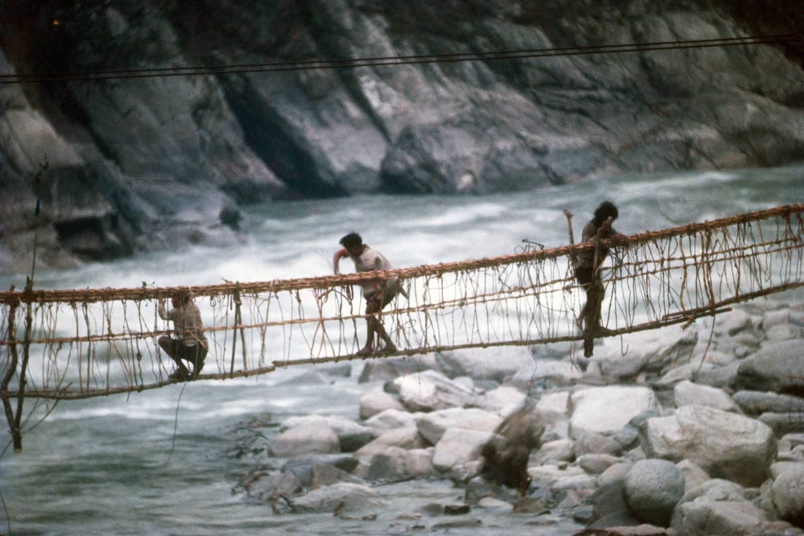
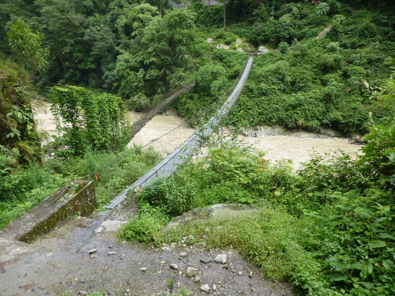
Figure 3 (left). The bridge made of woven vines over the Arun below Num, being repaired and upgraded by porters prior to its crossing by more than 285 porters, each carrying an 80-pound (36 kg) load (photograph by J. McNeely). Figure 4 (right). The metal cable bridge today. The old wooden bridge which replaced the bamboo and rope bridge of the 1970s can be seen to the left, or downstream, of the new metal cable bridge (photograph by A. Byers).
The AVWE team immediately set to work establishing a base of operations. Two stone and mud structures with waterproof woven bamboo roofs were constructed by helpful villagers from Lumdumsa. One served as the laboratory, kitchen, and sleeping quarters for the scientists and the other housed the expedition’s support staff (Figures 5 and 6). The team’s work began in the forests surrounding Labar, eventually branching out as far as the remote Barun Valley to the north and west, toward Mt. Everest. Living primarily on the rice, potatoes, and other supplies carried in by the porters, the scientists also welcomed seasonally available fruits and squashes from the nearest village of Lumdumsa, a two hour walk away, though they were well aware that the villagers were able to grow only a small surplus. They realized that the farmers welcomed cash, but selling vegetables might also mean that some would go hungry.
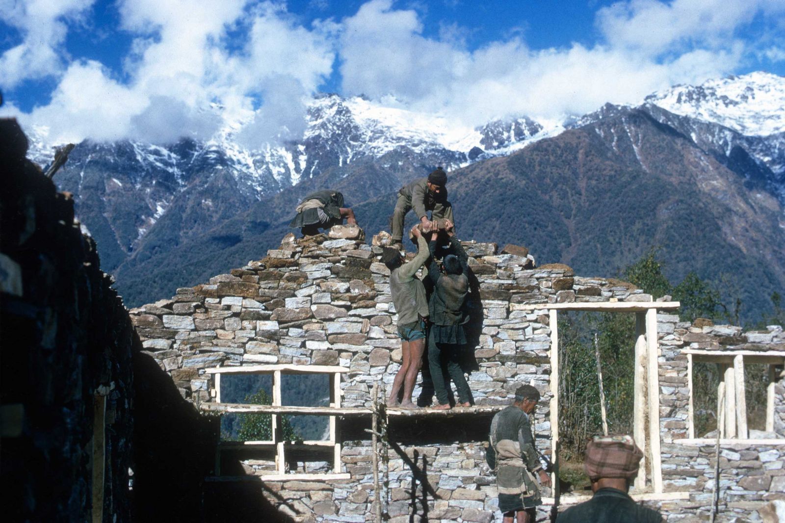
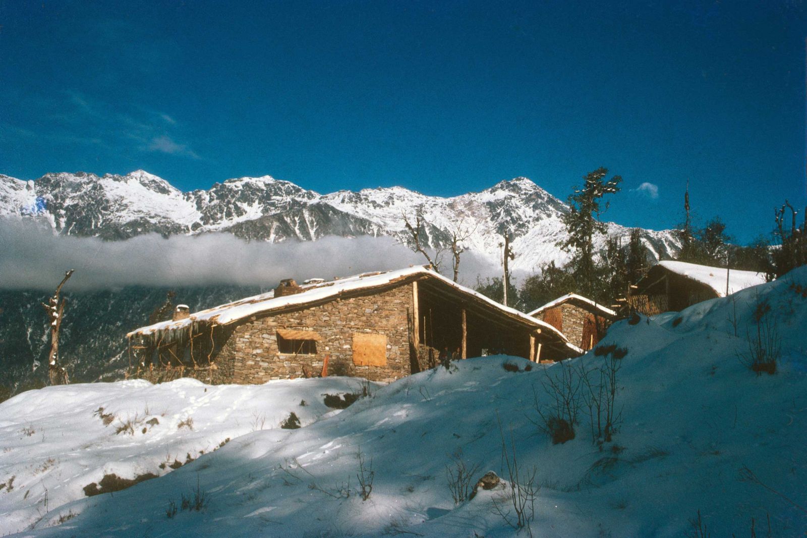
Figure 5 (left). Laborers construct the main living quarters for Cronin and McNeely’s staff (photograph by J. McNeely). Figure 6 (right). The final buildings. The Baule Peak range is in the background, and behind that the trekking route to the Makalu Basecamp (photograph by J. McNeely).
This part of the Himalayas is not an easy place to live, which helps explain why it had remained, for the most part, a wilderness. However, the expedition’s diet was enhanced during the rainy season and early fall by “…wild vegetables from the forest, including nettles, fiddleheads, and mushrooms” (Figures 7 through 10). Cronin reports that the American scientists were challenged by a monotonous diet, leeches, rain, and “sickness and deprivation” throughout the duration of the expedition. He nevertheless maintains that in retrospect he dwelt “…more on the good parts” of the expedition, and the “…comforts to our life in the field, comforts that go beyond friendships and beautiful views, that I now miss sorely.”
Ted Cronin’s 1979 book, The Arun, is a delightful account of the expedition and the Makalu-Barun region as it existed some 45 years ago, and perhaps one of the best natural histories ever written about a remote Himalayan valley in Nepal. Several particularly charming and memorable chapters in the book include Cronin’s study of the Orange-rumped Honeyguide (Indicator xanthonotus), a remarkable wax-eating bird found on cliffs deep in the forests of a tributary of the Kasuwa stream. Cronin camped for weeks in these forests to observe and document the birds’ behavior with only his assistant, Pema Sherpa from Thame village in Khumbu, the district that includes Mt. Everest, for company. He also documents the discovery of strange, seemingly anthropoid-like footprints in the snow the morning after he and Howard Emery had camped on a high ridge connected to Kongma La, described in a chapter appropriately titled “The Night of the Abominable Snowman.” And in a particularly insightful description of the treeless alpine zone (4,000-5,500 m) of the Makalu region, he referred to the region as being “one step from the moon” in terms of climate, the lack of air, and overall inhospitality to life.
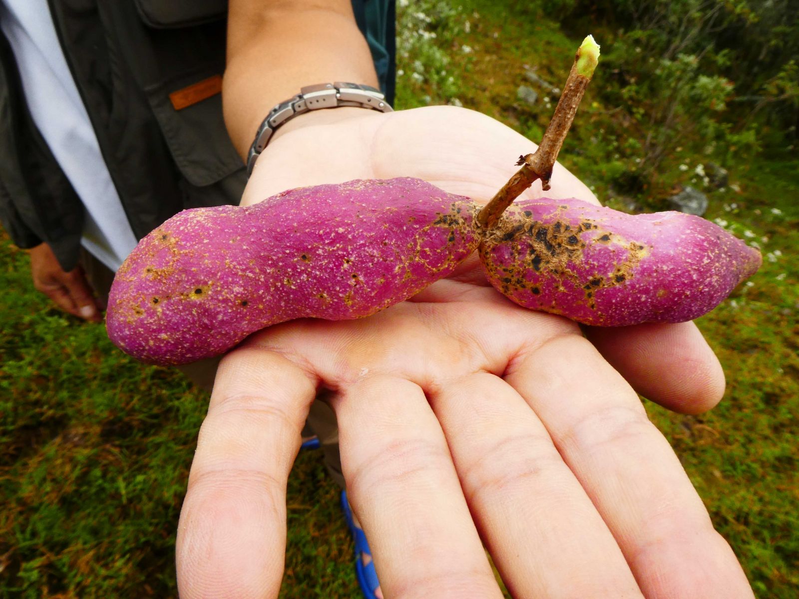
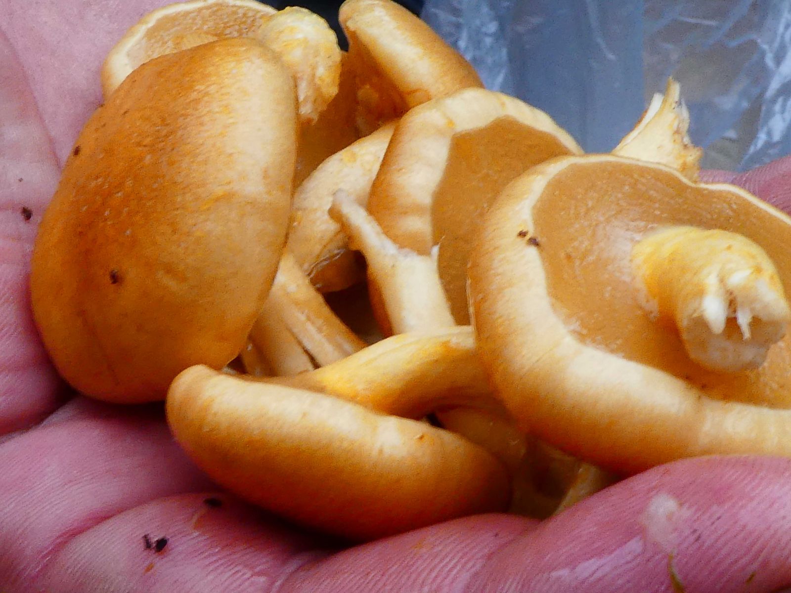
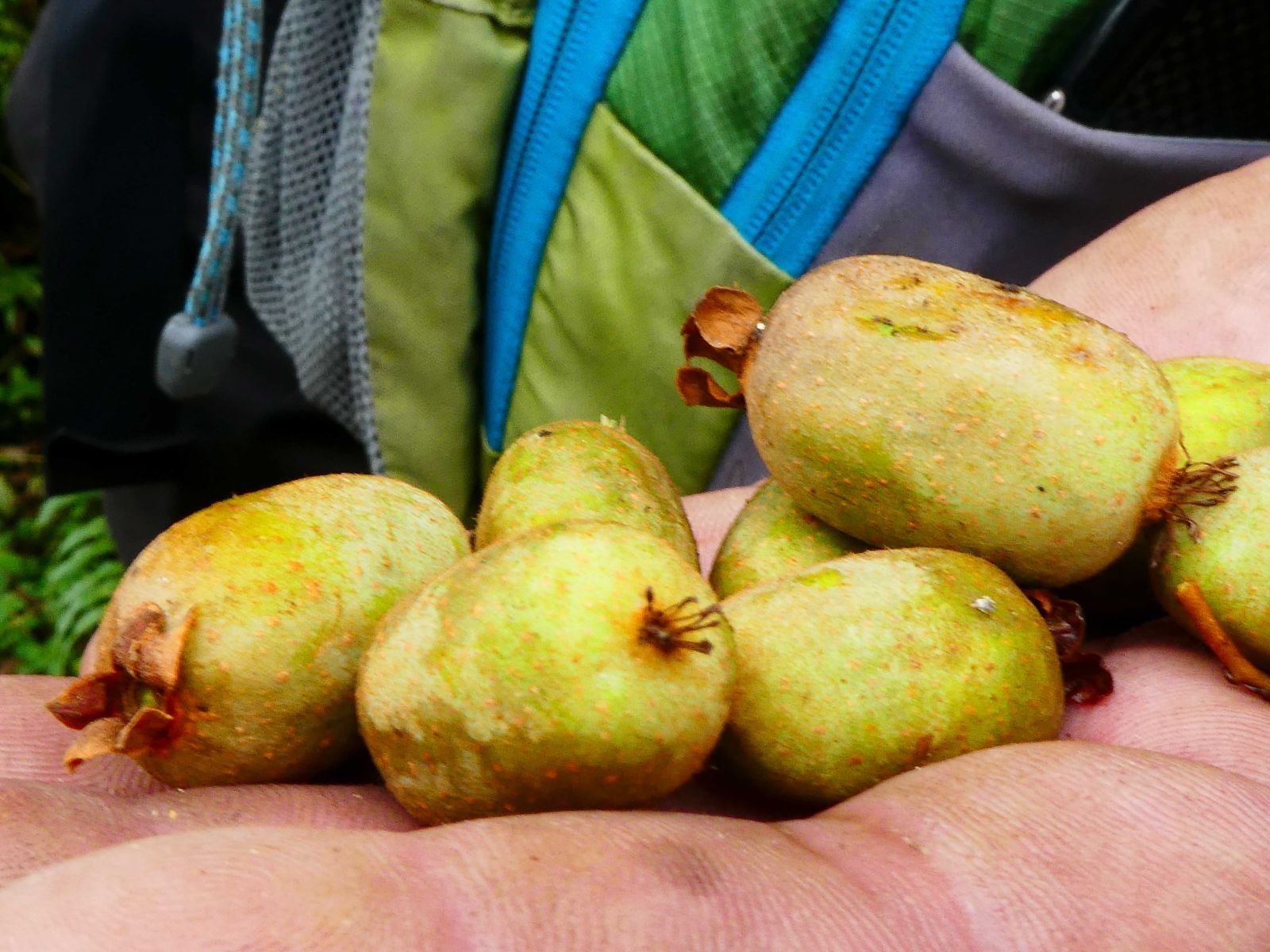
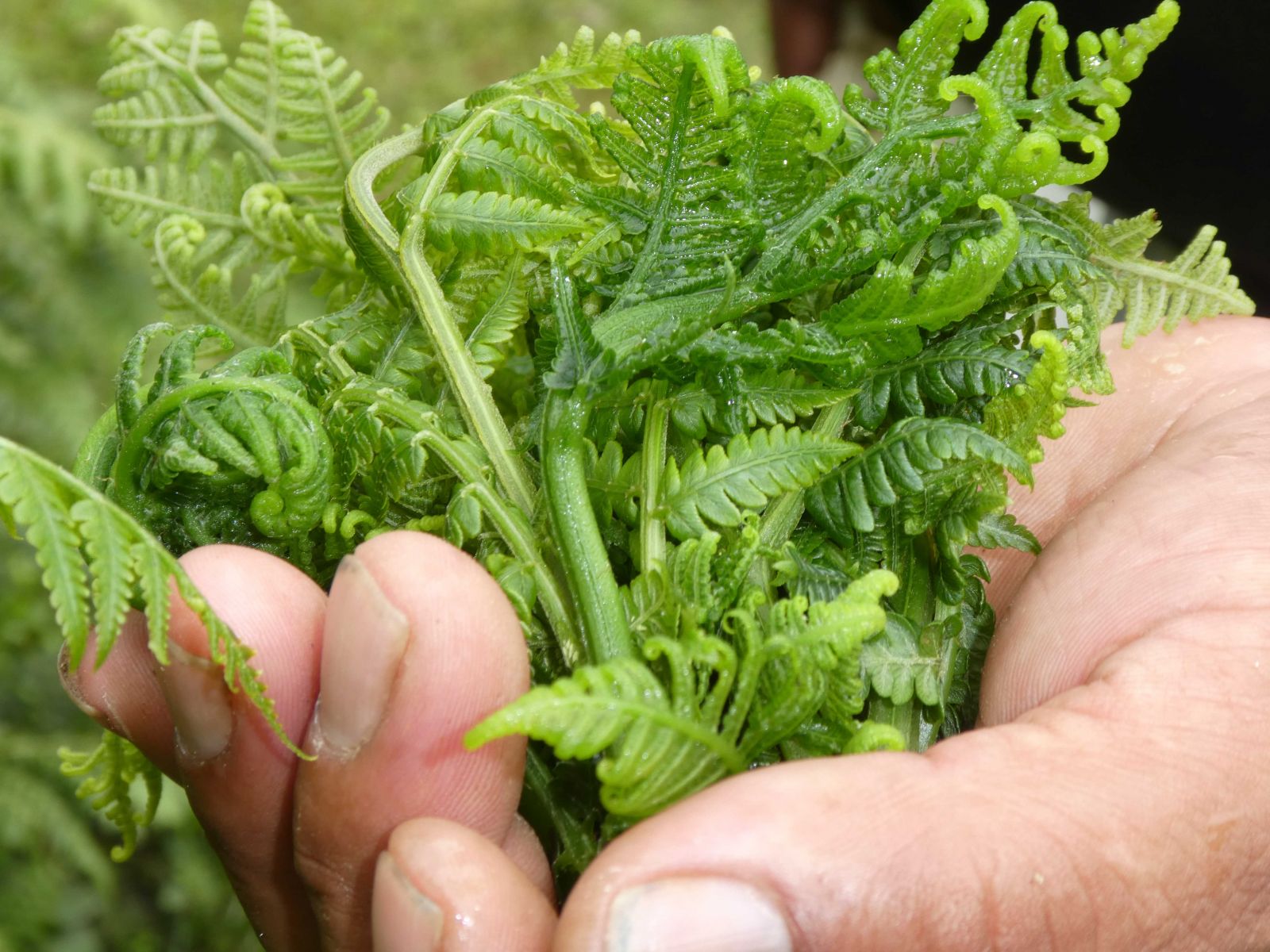
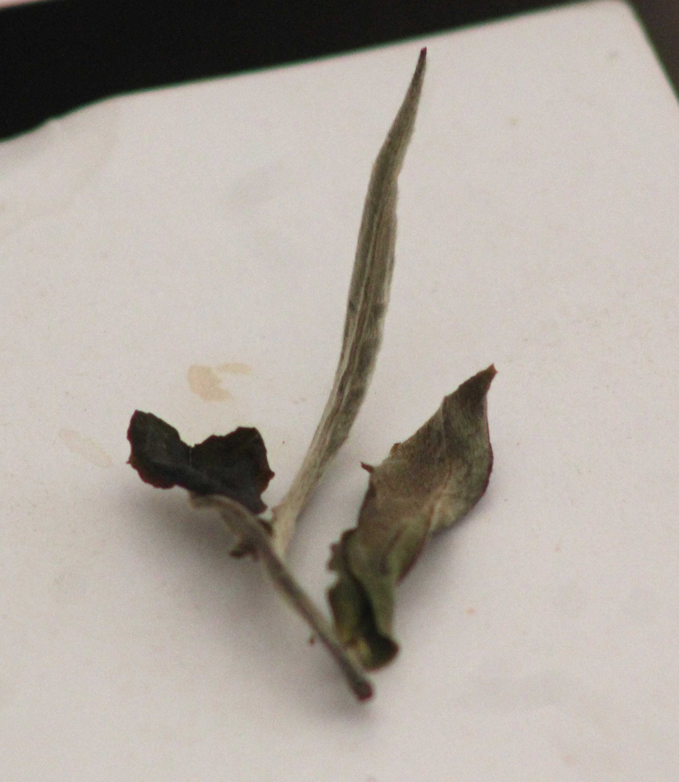
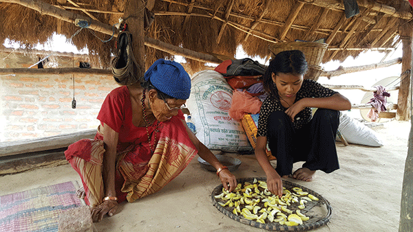
Figure 7. Mountain banana Figure 8. Delicious “Slippery” Figure 9. Wild kiwi Figure 10. Fiddleheads (photograph by A. Byers).
In addition to stories of the wildlife studied and daily life of the expedition members, the book also highlights the friends that Cronin and other AVWE members made among nearby villagers and staff during their time in Labar. Pasang Larkba, at the time about 50 years old, opened his home in Lumdumsa to the expedition as a storage facility for surplus supplies. Pasang taught Cronin much about the complexities of the Nepali language, the ways of life of the Arun mountain people, the local names for the region’s trees and wildlife, and many other aspects of life in a remote Himalayan valley.
Pasang’s wife Chamjii was a psychic and fortune teller [4] who, on special occasions and ceremonies, would mysteriously fall into a trance. In a “…high falsetto voice, part singing, part hissing, part calling…,” she would issue warnings to her neighbors about such things as the evil spirit who lived in a tree by a local stream, or the coming inclement weather and danger of landslides that it would bring. As quickly as she went into the trance, she would come out of it, acting as if nothing unusual had happened. Likewise, those who had witnessed it simply accepted it as part of who their neighbor Chamjii was, nothing more, and nothing less. She later told Cronin that she was happy to possess such powers, as they helped her people battle the invisible forces that caused them so much grief and hardship in their day to day life.
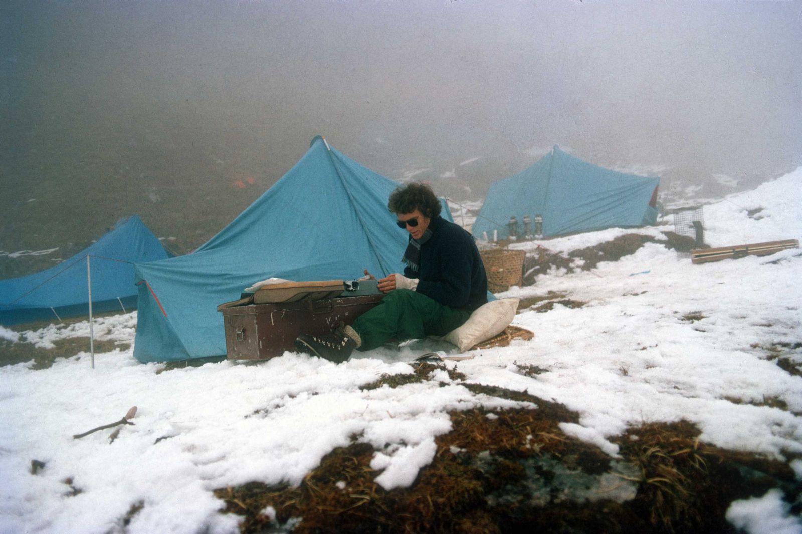
Figure 11. Ted Cronin at a higher elevation camp, typing up field notes (photograph by J. McNeely).
Two other villagers were especially appreciated by Cronin. Thorbu, from Lumdumsa, became Cronin’s prized porter and his best bird catcher and hunter. Tall for a villager and incredibly strong, Thorbu could carry a double porter load of 160 pounds (73 kilograms) for an entire day. He was so strong, fearless, and hard-working that Cronin invented all sorts of reasons to keep him around camp when the other porters were sent home. A particularly handsome man as well, Thorbu had a strong affection for women, as well as a phenomenal ability to drink. Unfortunately, while Cronin was on a brief supply run to Kathmandu, a relative of Thorbu’s, jealous of all the money that he was making working for the expedition, caught Thorbu in a drunken stupor (according to Cronin) and attacked him mercilessly with a two-foot long kukuri. The first blow sliced into Thorbu’s back, severing muscles, with the second landing on his head, slicing his ear and cheek so that the inside of his mouth was exposed. Left severely weakened and crippled, Thorbu told Cronin that he was nevertheless confident that he would return some day to work for the expedition, although perhaps carrying lighter loads. Cronin, however, had his doubts, given the weakened and crippled condition of his previously intrepid porter.
Urkan, also from Lumdumsa, became one of Cronin’s most valued field assistants. He reports that Urkan was a particularly intelligent young man who, after being taught the basics, could “carry out the most
complicated tasks, such as setting up the meteorological instruments, without even understanding the reasons for doing certain things in certain ways.” Cronin later realized that Urkan was teaching him more about how to get things done than he had ever taught Urkan. For example, Urkan could fix almost anything, and intuitively developed ways to better pack loads without bending tent poles, breaking delicate scientific instruments, or smashing jars of jam and peanut butter. And at the young age of 17, Urkan was already happily married with a wife, two children, and his own house, and thus in Cronin’s mind had already achieved the “real goals of human existence.”
I’ve read The Arun a dozen times over the years, ever since first special ordering it from a bookstore in Northern Virginia in 1979, then waiting impatiently for weeks until it finally arrived (there was no Amazon.com back in those days). From that day forward, I had always wanted to visit Labar, to discover what remained of the basecamp, what became of the research results, and what eventually became of the various expedition members. According to our guide, Lakpa Norubu Sherpa from Ekuwa village, the only other foreigner who had visited Labar since the AVWE’s expedition was an injured Japanese man, carried through by a porter from Deurali after having suffered a sprained ankle during one of Lakpa’s trekking expeditions several years ago.
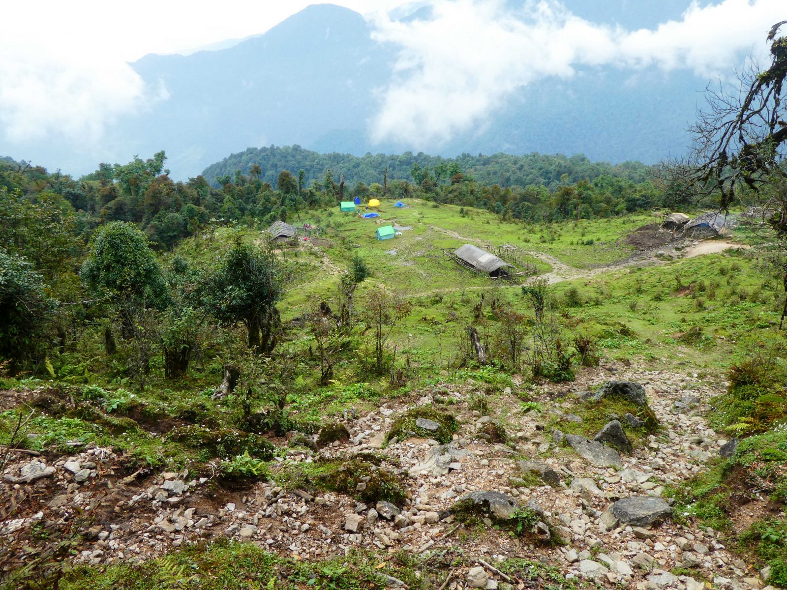
Figure 12. First sight of the Labar clearing when coming out of the forest (photograph by A. Byers).
Unfortunately, in spite of a decades-long research and conservation career in and out of Nepal that was to follow, I never got the chance to visit Labar. Not even while living for two years in the nearby village of Khandbari in the early 1990s working as Co-Manager of the then-new Makalu-Barun National Park and Conservation Area (later Buffer Zone) [5] . In October 2018, however, my wife Elizabeth, and I once again returned to the Barun valley to continue our study of the glacial lake outburst flood [6] that occurred there on April 27, 2017. The new trail we were exploring and mapping happened to pass not far from the AVWE basecamp of some 45 years ago, and we eagerly detoured to visit it.
Lakpa had spent the first 12 years of his life herding yaks in these kharkas and could identify nearly every edible plant, fruit, and mushroom along the way, a bonus for our palates since we were trekking in the traditional wild food gathering month of October (Figures 7-10) He was also familiar with all of the kharkas and little-known trails in the region that connected them, providing practically limitless opportunities for the trekker, mountaineer, and researcher to explore trails and viewpoints rarely if ever visited by non-locals. And this, as we were to discover, was one of the Makalu-Barun National Park’s best kept secrets.
Descending from the forest one day to an overlook above Labar was a moment of pure joy for me (Figure 12). I had finally made it, after all these years! And here before me was the place where the first in-depth scientific study of the Makalu-Barun region had taken place, with discoveries that eventually played a role in the region’s protection as a national park. In a practical sense, Labar turned out to be a well-used lower pasture area that many local herders passed through on their way to and from the higher altitude summer pastures that are covered in deep snow all winter.
Three bamboo thatch-roofed goths (herder shelters) were part of the cleared landscape, next to what were clearly were the ruins of AVWE’s lab/sleeping quarters/dining hall buildings off to the west. Several cattle grazed in the distance, chickens pecked and clucked around one of the goths, and cow pies littered the pasture which, at this relatively low altitude, already had me thinking of higher and more desirable camping sites for our long overdue rest day. Whether or not the surrounding upper-temperate forest of oaks, magnolias, and rhododendron could still be classified as “healthy” was perhaps open to debate, as there was abundant evidence of significant human and livestock disturbance (trampled earth, cut trees, eroded hillslopes). But we went to sleep that night to the periodic calls of the Tawny Wood Owl (Strix aluco), perhaps a descendant of the “…earless, brown-eyed form sitting hunched in the black retreat of the forest canopy” that Cronin says he used to listen to in the evening.
Upon closer inspection, and by comparing McNeely’s photo of the living quarters in 1973 (Figures 5 and 6) with what was before me in 2018 (Figure 13), I could clearly make out the ruins of the chimney and fireplace that must have been the core of the sleeping quarters and central room, as well as a second fireplace in the adjacent room that must have been the kitchen that “… could provide meals well above trail standards.” A second nearby building was all that remained of the Sherpa staff’s living and cooking quarters. When I asked the local herders why they had never moved into the buildings, they said that “…we always expected that Dr. Ted would come back someday.” When he didn’t, the buildings simply weathered into the ruins seen today.
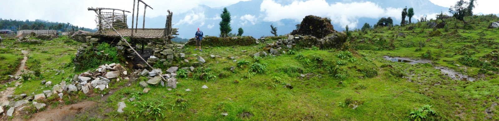
Figure 13. The remains of the basecamp in 2018 (photograph by A. Byers).
Cronin’s friends Pasang and Chamjii of Lumdumsa village had both passed away some time ago, Pasang at the age of 80 sometime around 1998 and Chamjii in 2008, reportedly at the age of 100. They had had a total of 10 children, five male and five female, and except for one all of them had died either in childbirth, at a fairly young age, or in the case of one brother, disappeared in India. The youngest son, Lakpa Norbu Sherpa, survived, and when he heard that we were looking for him he caught up with us on the trail the next day as we were making our way to the next camp. Now 55 years old, Lakpa Norbu related that he had worked for Cronin and McNeely as both a porter and builder of the two basecamp structures when he was 15 years old. Now the proud father of six daughters and two sons, he has his own house in Lumdumsa, but still uses his father’s old house for storage. Lakpa also confirmed that Chamjii and several of her sisters had all been kangduma, or fortune tellers, but that Chamjii had been the best. She passed her gift on to him on his 40th birthday, and these days he considers himself to be a pretty good fortune teller as well. He remembered that there were 5 or 6 western scientists working full time at Labar, which according to McNeely were himself, Cronin, Howard Emery, Jim and Karen Foster (both botanists), and David McNeely (logistics officer).
The next day, a rest day at the Deurali camp, we also met 63-year old Tenzing Sherpa, known locally as “Dami Sherpa” because of his spiritual connections with yetis (locally known as shokpa). As a young boy, he became lost in the forest for a week and encountered a yeti spirit, which he bonded with, and ever since has had the power to perform yeti pujas for people who are either being tormented or suffering from ill health as a result of shokpa spirit mischief. Dami Sherpa says that he carried rocks and mud for Cronin during the construction of the basecamp structures, and he was well acquainted with Pasang, Chamjii, Urkan, Thorbu, and the others mentioned in the book. As for Cronin’s yeti tracks, he himself claims to have seen such tracks as well, and 20 years ago was so frightened by the noise that something—he’s not sure what, but it was big and powerful—was making while crashing its way through the forest that he ran, leaving his kukuri behind in the process. But, no, he’d never seen a real flesh and blood yeti or shokpa. Tenzing must also have been one of Cronin’s personal assistants, as he remembers catching birds in mist nets.
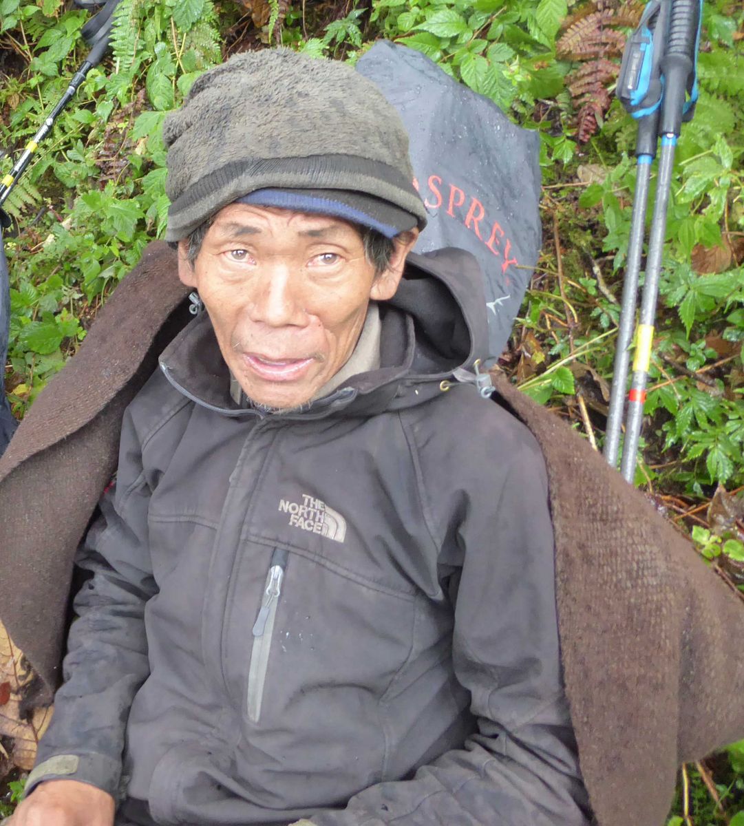
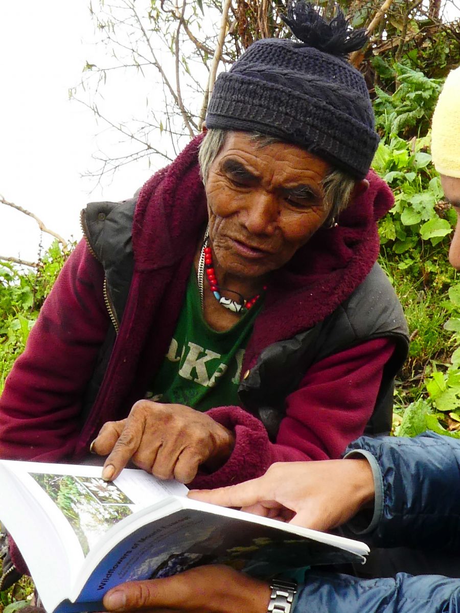
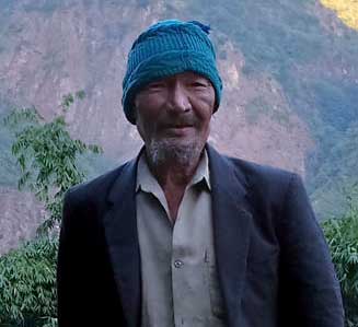
Figures 14 (left). Lakpa Norbu Sherpa, Pasang and Chamjii’s youngest son, in 2018 (photograph by A. Byers). Figure 15 (middle). Tenzing Sherpa in 2018, examining Elizabeth’s draft “Wildflowers of the Mt. Everest Region” (photograph by A. Byers). Figure 16 (right). Thorbu Sherpa in 2018. The scar on the left side of his face is still visible, but otherwise Tharbu is looking remarkably good for someone 75 years old, and who at one time Cronin thought was destined to be a cripple for life (photograph by L. Sherpa).
And then there was Thorbu. Contrary to being a pathetic and weakened cripple, he turned out to be the uncle of our sirdar Lakpa Norbu, and is alive and well at 76 and living in lower Ekuwa village. Apparently as resilient and quick-healing as he was strong, Thorbu ended up marrying a young Rai girl and eventually had two sons, one daughter, and now 10 grandchildren. He reports that he did indeed work for “Dr. Thet,” and confirmed that he spent most of his time hunting and catching birds, a skill at which he excelled. He is especially proud of catching a Tawny Fish Owl (Ketupa flavipes) near Tumlingtar airport that he says “made the videshi (foreign) researchers extremely happy,” as apparently the bird was quite rare for that altitude and forest type. And to further clarify Cronin’s fight story a bit, Thorbu claims that he was simply drinking socially and chatting with friends when his neighbor Chhebi, jealous at all the money that he was making when clearly the AVWE’s job was meant for him, attempted to decapitate him with a long, hooked knife locally called a katti. But the potential force of the blow was minimized when the knife caught on a ceiling rafter above. And that yes, the second blow split his ear and sliced a new cavern in his mouth, but immediately after the blow had been dealt he was still able to “pick the son of a bitch up, lift him over my head, and throw him down on to the ground,” before the others jumped in to stop the fight.
Chhebi was taken into custody by the police, but as Cronin reports bribed his way to freedom and escaped to Ilam where, according to Thorbu, he died some 30 years ago.
Both Urkan and Pema are reportedly alive and doing well, Urkan in Walung (a village in the eastern Buffer Zone) and Pema in Thame (a village in the Bhote Kosi Valley, Sagarmatha (Everest) National Park and Buffer Zone). In fact, on previous expeditions to the Barun valley in 2014, 2016, and 2017, we regularly encountered younger people whose fathers or uncles had worked for the expedition so many years ago, and they all spoke highly of the AVWE.
After leaving Labar, we still had a good three weeks of field work and trekking time left ahead of us in order to accomplish our expedition’s multiple objectives [7]. The travel took us through some of the most beautiful forested, alpine, and snow-capped landscapes in Nepal, a rugged and wild land that is still pretty much off the tourist radar screen and Kathmandu trekking map industry. But for me it was a particular delight to have been able to finally visit Labar, to examine the ruins of the basecamp and imagine the kinds of experiences and adventures the scientists must have had there some 45 years ago. And, best of all, to connect with a number of the local people mentioned who were critical to the expedition’s success. We tend to think that once a book that we’ve purchased ends, all that was narrated ends with it as well. But life goes on, as it did for nearly all of the people mentioned in the book, although in some cases in strange and unpredictable ways.
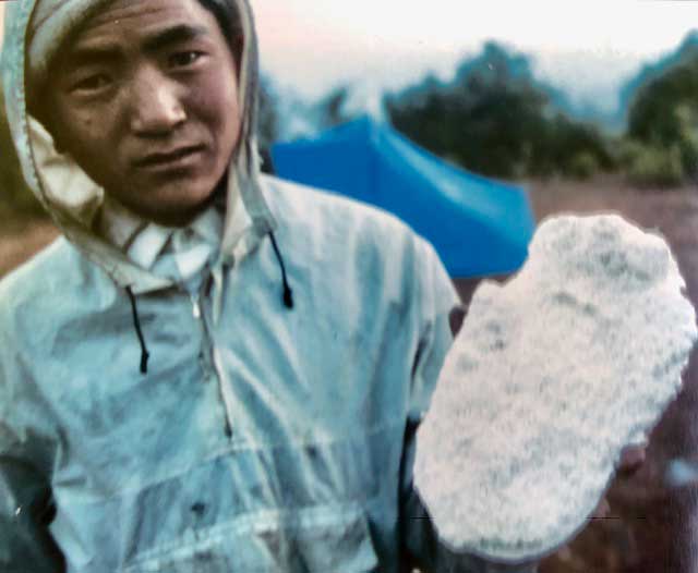
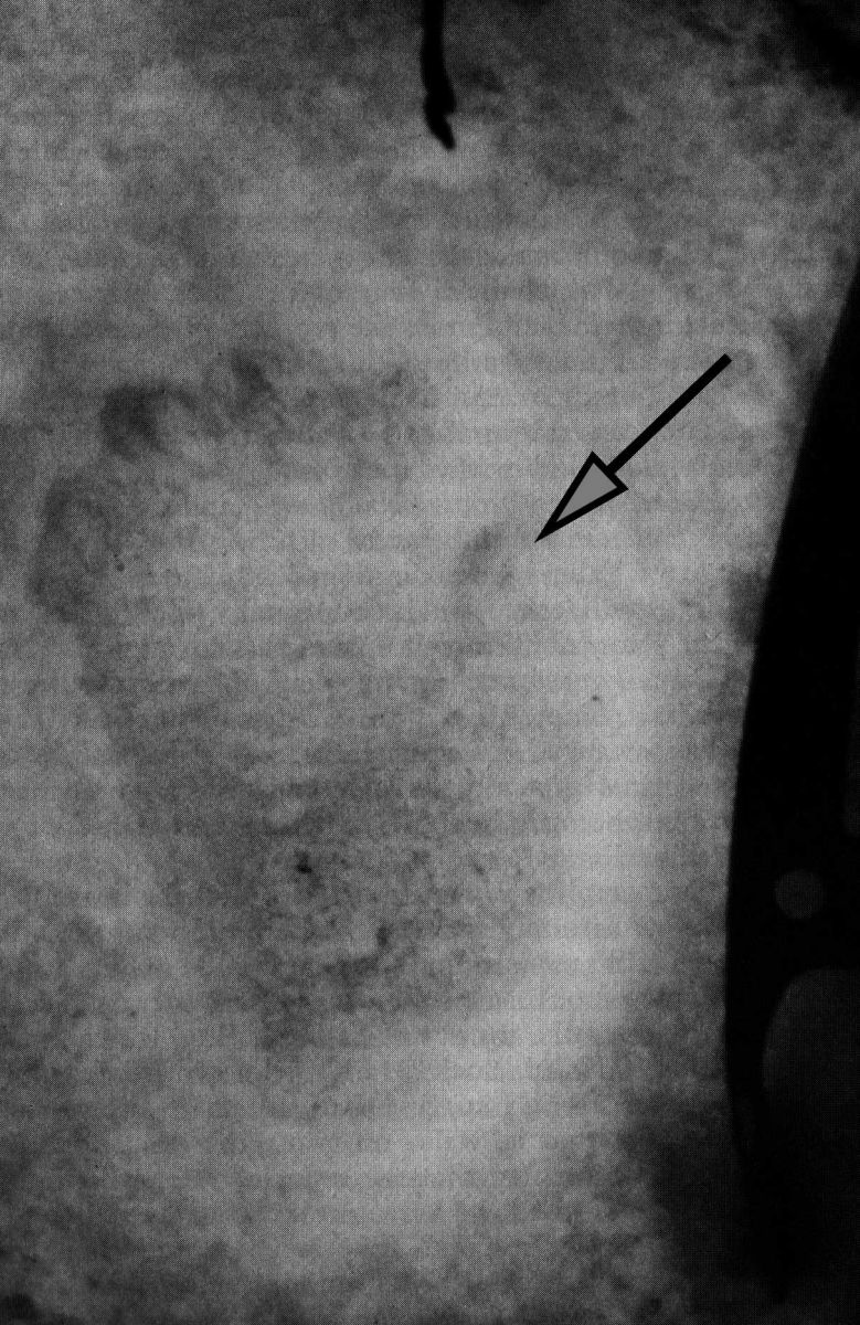
Figure 17 (left). Jeff McNeely’s research assistant, Ang Babu Sherpa, holding one of the plaster casts that McNeely made of the tracks found in Cronin and Emery’s camp near the Shipton La (photograph by J. McNeely). Figure 18 (right). Photograph of one of the tracks in the snow. Arrow points to the opposing thumb feature that wildlife biologist George Schaller, when inspecting the cast, said reminded him of a mountain gorilla track (photograph by T. Cronin; some brightness/contrast adjustment performed by the author for enhanced print visibility).
Thanks to Cronin and McNeely’s passion for the Makalu-Barun region and its people, the squeaky wheel that eventually led to the region’s protection as a national park and buffer zone started to spin. In an AVWE report to His Majesty’s Government/Nepal dated 27 January 1974, McNeely included a recommendation that:
“…the Iswa-Kasuwa-Barun area be protected by law through inclusion in a National Park or in a Reserve as defined in the “National Parks and Wildlife Conservation Act, 2029,” and that it receive special management measures to be administered by the Wildlife Conservation and National Parks Division of the Department of Forestry, HMG.”
In a recent email, McNeely provided additional details as follows:
“We of course saw the great potential of the Makalu-Barun for an outstanding protected area and of course discussed it with Hemanta [Mishra] [8] and John Blower, who was leading the FAO project supporting the establishment of Nepal’s first national parks. Their focus at that time was in the Terai, especially Chitwan, with their mountain interests focused on Sagarmatha and Langtang. So they were glad to have us in
Makalu but did not yet h
ave the staff capacity to give much attention to such a remote area so it was put in the “to be addressed later” file. Quite rightly, in our view. And the subsequent development of Annapurna as a community-conserved area provided a model that would be appropriate for Makalu-Barun as well.”
Nearly a decade later in 1983, the conservationist/educator Daniel Taylor chose the lower Barun Valley as the stage for his life-long fascination with the yeti [9] and Himalayan black bear. For a variety of reasons, Taylor concluded that the tracks observed by himself and others before him were most likely those of the Himalayan black bear, created through a process known as “direct registration” where the rear foot is placed precisely over the front foot track, creating an impression that is more human in appearance than animal. Still, Taylor was so impressed by the beauty and biodiversity of the Makalu-Barun region that he brought it to the attention of his friend and former classmate at Harvard, the late King Birendra Bir Bikram Shah. King Birendra was a great supporter of conservation [10], and by 1992, thanks to the hard work of numerous Nepali and international conservationists [11] and Taylor’s own staff at Woodlands Mountain Institute [12], the region was formally gazetted as the Makalu-Barun National Park and Conservation Area (later Buffer Zone).
Meanwhile, AVWE’s yeti tracks have continued to be a source of both fascination and controversy through the years, at least in what has now become a copious literature arguing for or against the existence of such a creature. In December 1972, Cronin and Emery were camped in the snow on a high alpine ridge that spurred off from Kongma La, the first of their many subsequent high altitude research trips. The next morning, Emery emerged from the tent to find a new set of tracks through the camp that had been made during the night, tracks that their Sherpa companions identified matter-of-factly as being those of the yeti.
Cronin and Emery proceeded to take measurements and photographs of the prints, which were unlike those of any of the bear tracks that they had encountered and photographed, and which were remarkably similar to those discovered by the mountaineer Eric Shipton in 1951 on the Menlung glacier in the Everest region. McNeely arrived shortly afterwards with plaster of paris to make casts of the tracks, distinctive in that while they looked like a human print, they exhibited a large, opposing thumb that the eminent wildlife biologist, George Schaller, later said exhibited “…a close resemblance to those of the mountain gorilla.” Add to all this the words of a shikari (hunter) that Cronin had interviewed during the first days of the AVWE:
“Oh yes! We have many kinds of wild animals in these forests. There are bears, and musk deer, and yeti, and pandas, and leopards, and civets, and monkeys, and many, many more,”
and one can’t help but wonder.
Recently I asked Jeff McNeely what had become of the plaster casts. He responded that:
“…they were confiscated by Customs at the Kathmandu airport when Andrew Laurie [a Cambridge University wildlife biologist who was studying the Asian Rhinoceros in Chitwan at the time] tried to take them to Bangkok for me. He was asked what they were, and he innocently responded “yeti footprints,” so the Customs officials confiscated them because they were ‘national treasures’ and never seen again.”
Cronin outlines a number of factors that, while not necessarily suggesting that an “Abominable Snowman” does indeed exist, nevertheless point to “…a real and unresolved enigma concerning a creature that walked by my tent one night.” They include the fact that there had not been time for the sun to melt and transform the tracks into a yeti-like appearance, which had been widely hypothesized for other track discoveries; that the tracks were unlike any known fauna of the Makalu-Barun region; that the prints were nearly identical to those found by Shipton, only smaller; and so on. Like the spiritual powers demonstrated by Chamjii, Cronin is content to believe that there are some things that science simply cannot explain, no matter what the scientists say, and leaves it to the reader to decide what the tracks may or may not have been.
In addition to yetis, wax-eating birds, and the colorful local people encountered, The Arun spends considerable time highlighting Cronin’s concern over the Himalayan environmental “doomsday scenarios” that were popular during that period. Fortunately, the catastrophic levels of deforestation and soil erosion predicted never quite happened, at least not as vividly as imagined in the offices of the United Nations in New York City in the early 1970s. But that’s not to say that the scenario hasn’t been replaced by new threats that are of equal or greater concern. They include such things as the devastation of the Maoist insurgency (1996-2006), the 2015 earthquake that destroyed the Kathmandu Valley and much of the country, the outmigration of thousands of young men annually due to the lack of jobs in the region, and the dramatic increases in poaching of large mammals and rare plants, to name a few. Poaching has become a major problem in the Arun, especially with the new road from Tumlingtar to the border with the Chinese province of Tibet at Kimatanka providing easy transportation, certainly compared to the pre-road days when all travel was done by foot and all loads carried on someone’s back. Today jeeps transport their illegal cargo to the ready markets at the border for musk deer pods, bear gall bladders, bush meat, and the rare and valuable medicinal plants so highly prized by some Chinese. While the park and military are making a concerted and admirable effort to control this unprecedented growth in poaching pressure (Figures 21 and 22), there are just too many ways that poachers can avoid detection in the wilderness regions, and to hide their illegal products in ways that pass regularly over the border to markets in China (e.g., hidden in bundles of the legal and medicinal plant chiraito).
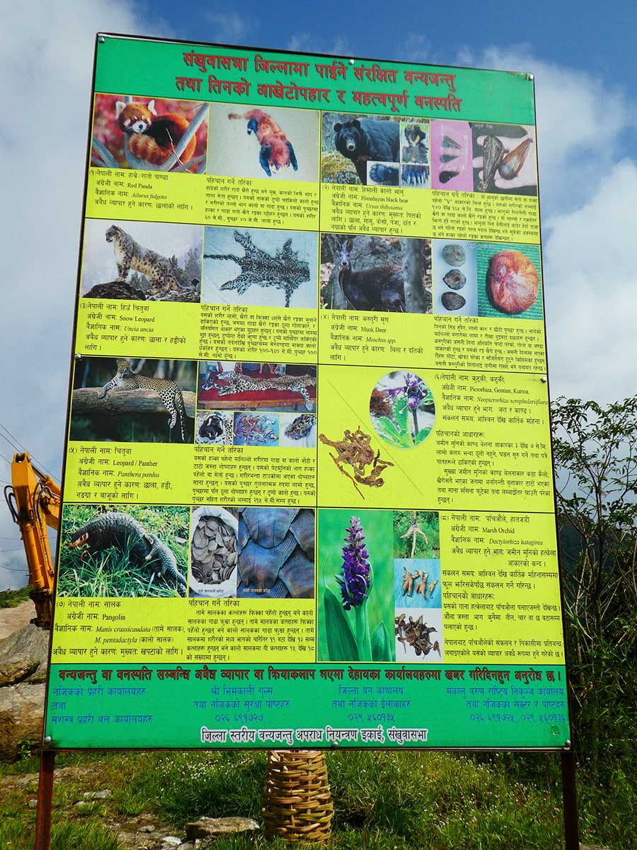
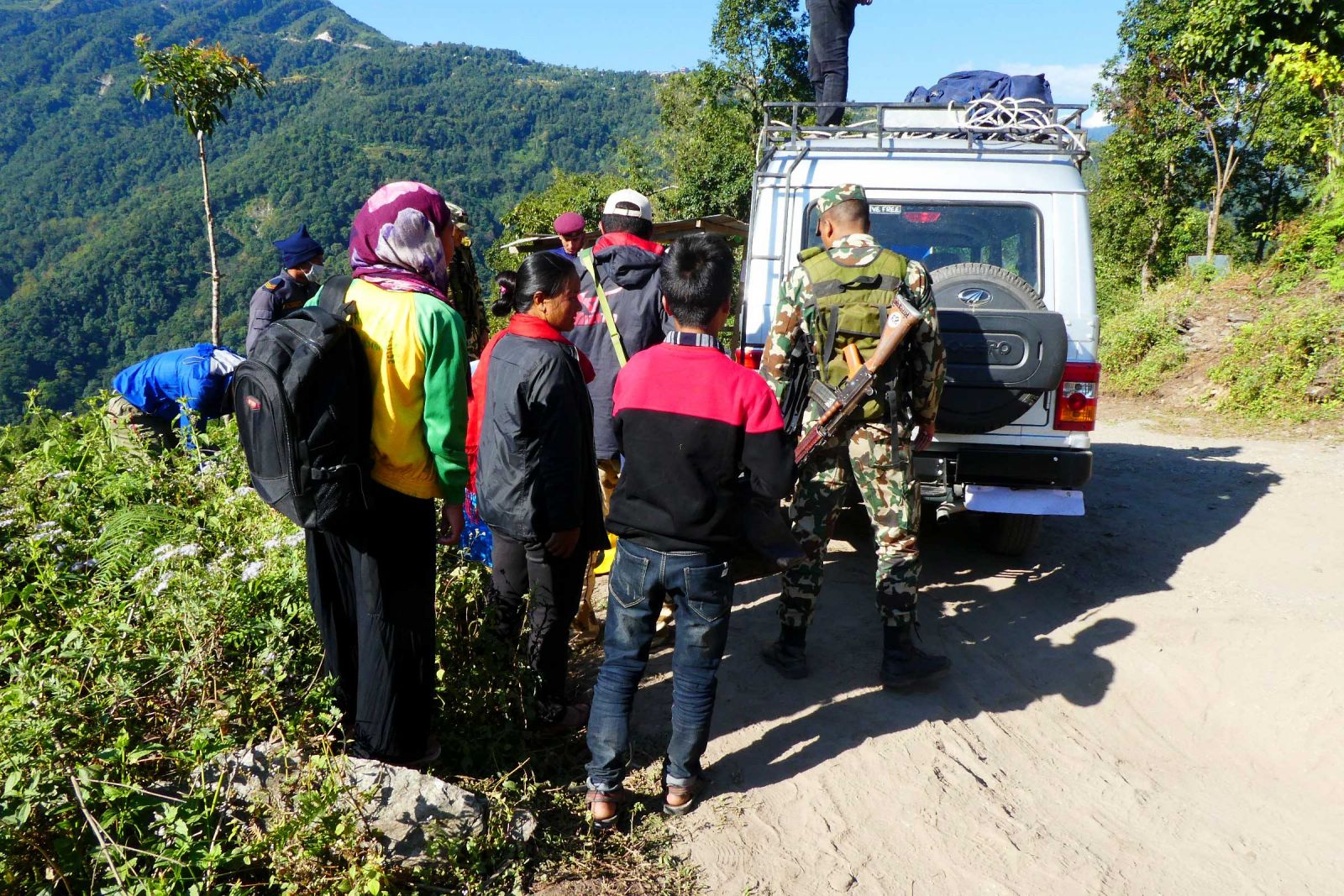
Figure 21 (left). Signboard in the village of Chichila showing illegal wildlife and plant products (photograph by A. Byers). Figure 22 (right). Our vehicle being searched by the Army (photograph by A. Byers).
Which begs the question: can the iconic biological treasures of Makalu-Barun survive? Can the magic of the region that Cronin and McNeely experienced still remain in the face of a myriad of new challenges and threats?
The answer, I think, is yes, absolutely. And perhaps a good place to start would be the re-introduction of the nature-based economic development and cultural conservation programs pioneered by the Department of National Parks and Wildlife Conservation (DNPWC) and The Mountain Institute (www.mountain.org) during the early years (1990s) of the park’s establishment. Specifically, this would involve the promotion of more adventure- and nature-based tourism jobs—cooks, guides, and lodge managers, for example, with concurrent English language training. Income generation and nature conservation could go hand in hand, and very well act as a deterrent and alternative to the currently unacceptable levels of wildlife poaching. For example, thanks to the work of numerous Nepali and foreign conservationists over the years, it is now common knowledge that tigers and rhinos in the Terai are worth far more alive than they are dead. The same could be true for the wildlife and plants inhabiting the dense, high altitude forests of the Makalu-Barun region—if only given a chance.
However, the construction of new roads in the region will also need to be carefully factored into any new “nature-based economic development” equation. While the past decade’s proliferation of road building has assuredly brought numerous benefits to local people in terms of access to health facilities, cheaper foods, and enhanced communications, it has also resulted in the destruction of formerly pristine forest and alpine habitats, unsightly strip towns, major garbage deposits, the acceleration of soil erosion and landslides, and many of the other ills characteristic of urban societies and unregulated growth elsewhere. These problems, of course, I will leave to the concerned authorities to address. However, the same authorities will need to wake up to the fact that “trekking Nepal” is far different from “motorable road trekking Nepal,” and that selling a trek that in fact involves many kilometers of road walking, such as the Ghandruk-Ghorepani loop, or now most of the Annapurna circuit, will eventually lead to decreased trekking tourist populations [13]. In short, you can have trekking tourism, or you can have roads, but you can’t have trekking tourism that includes days of walking upon the roads. Far better to keep the two separate.
In the 1970s, Cronin maintained that the Makalu-Barun region “…is considered too remote for most pleasure trekking parties,” which is no longer true in terms of the dramatically enhanced road and air access to the place that has occurred since then. But for the moment, the spectacular landscapes, challenging and remote trekking conditions, and colorful, friendly villages of the Makalu-Barun still offer unparalleled opportunities for trekkers to experience the peace, beauty, mystery, reflection, and discovery that Cronin, McNeely and the AVWE team of scientists in The Arun found two generations ago. Careful stewardship of the region, hand in hand with thoughtful economic development, could keep it that way.
Mountain geographer Alton C. Byers, Ph.D. is a Senior Research Associate and Faculty at the Institute for Arctic and Alpine Research (INSTAAR), University of Colorado at Boulder; and a Senior Fellow at The Mountain Institute.
Acknowledgements: Jeff McNeely is warmly thanked for his numerous reviews of the manuscript, suggested edits and additions, provision of photographs from Labar, and detailed information and insights regarding the AVWE. Dr. Daniel Taylor, Dr. Johan Reinhard, Ms. Lisa Chogyel, and Dr. Andrew Laurie are also thanked for providing valuable information related to the story of McNeely’s plaster casts of the “yeti” tracks. Thanks also to Elizabeth Byers and Rakesh Kayastha for producing the place map.
Footnotes:
[1] Now CEO of Manchester Capital Management, Manchester, Vermont.
[2] From 1977 onwards, McNeely was to lead a long and distinguished career with the International Union for Conservation of Nature (IUCN).
[3] All quotes are taken directly from Cronin’s 1979 book The Arun: A Natural History of the World’s Deepest Valley, Houghton Mifflin Company, Boston.
[4] Known locally as a lhawa, or “spirit caller.”
[5] See: “A Walk Across Makalu-Barun,” ECS Nepal, July 2018.
[6] See “Chasing GLOFs in the Nepal Himalaya,” ECS Nepal, January 2019.
[7] See our “Makalu-Barun Circuit Trek, Nepal” Story Map and blog at https://www.arcgis.com/apps/MapJournal/index.html?appid=7ac17d44a82d49eca74fc54b9fd030d1 for a day-by-day account of two new, out of the way treks in the Makalu-Barun National Park that we completed in October, 2018.
[8] See: Mishra, H.R. and Ottaway, J. 2018. On His Majesty’s Service: Royals: Hippies & Hustlers, British Film Makers & Tibetan Khampa Guerillas, United Nations and American Peace Corps, Mt. Everest Summiteers and Battles for Conservation in the Himalayas. Kathmandu: Vajra Books.
[9] See: Taylor, D. 2017. Yeti: the Ecology of a Mystery. Delhi. Oxford University Press.
[10] See: Mishra, H.R. and Ottaway, J. 2018.
[11] They include, but are not limited to, Dr. Tirtha Shrestha, Dr. Hemanta Mishra, Mr. Lain Singh Bangdel, Dr. Mohan Sainju, Mr. Bishou Shah, General Sushil Shumshere, Mr. B.N. Upreti, Mr. Kazi Nepali, Dr. Lhakpa N. Sherpa, Dr. Kamal Banskota, and Mr. Rohit Nepali. International advisors and key figures in the project included Dr. Daniel Taylor, Dr. Robert Fleming, Dr.s Craig and John Craighead, Dr. J. Gabriel Campbell, Mr. Bob Davis, and Alton and Elizabeth Byers.
[12] Woodlands changed its name to “The Mountain Institute” around 1993. See: www.mountain.org
[13] However, mountain biking along roads is reportedly increasing in the Annapurna circuit region, but I refer here to trekking and/or adventure tourism and the more pristine conditions which tourists rightly expect.